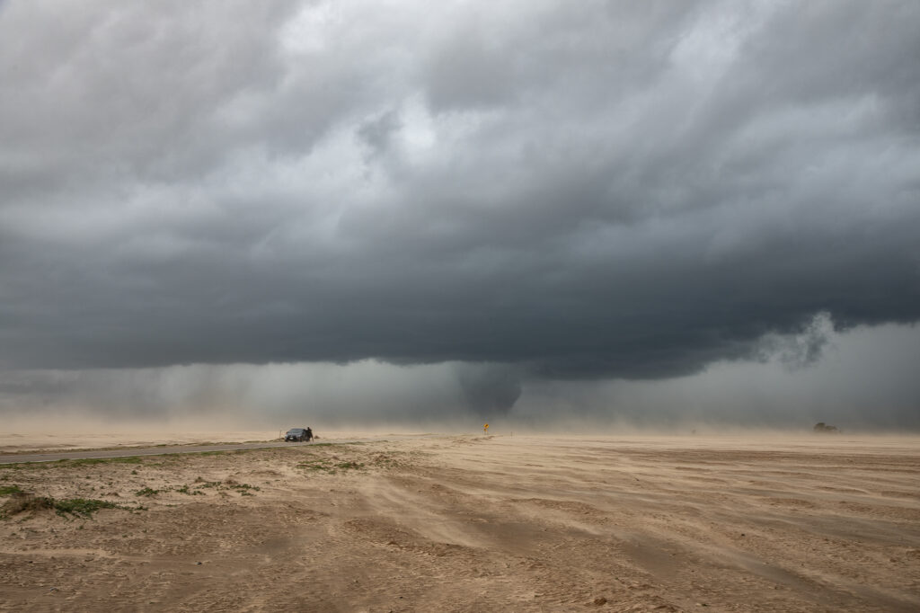
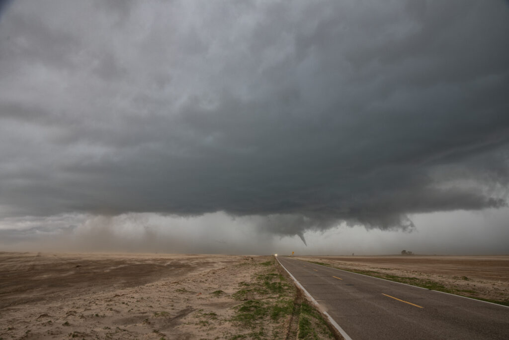
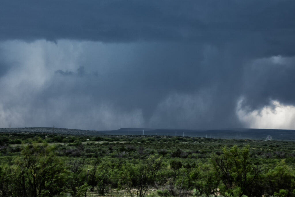
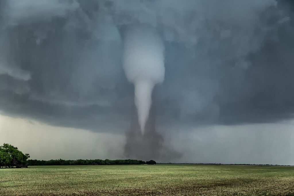
What a day April 24th was!! There was a high threat for supercells and if one could latch on to a boundary in place it had the potential to produce tornadoes. Strong shear, great moisture for late April standards, and good instability were all present. I headed down from Woodward to the Texas Rolling Plains. When I arrived, a supercell had formed and started spinning hard not far from Silverton. As I approached it from the east at Turkey, I encountered baseball sized hail and dropped south to get out of it. I set up my camera and soon an elephant trunk shaped tornado formed. It planted firmly for about 10 minutes before dissipating. Soon the storm started reorganizing and I dropped south to just north of Matador. It cycled and developed a wall cloud, then a bowl and then a multivortex tornado. That turned into a huge cone, then close to a wedge before becoming rain wrapped. It was on the ground for probably 25-30 minutes!! After that the storm became quite HP and, having to be back in Oklahoma City that night, I left it and proceeded back to our base city. An amazing day, structure, 2 tornadoes, huge hail and lightning. Enjoy the pics!

April 2-4 Arkansas, Tennessee and Texas Tornado Warned Supercells
We ran an on call storm chasing tour in TN/AR/TX during the April 2-4 period. We caught numerous tornado warned supercells, however on the Lake City, AR day (4/2), we debated whether to play west of the MS river or east. (Very few crossings!) Parameters were pretty sweet. We ultimately chose east (ugh) due to several discrete cells and at that time nothing west of the river. Sooo, no tornado for us! Chased a half dozen tor warned storms, but nothing produced in TN, till after midnight of course.
Second day we chased southwest AR/NW LA. Storms formed southwest of us (Ida, LA) and became tor warned. As they approached and crossed the front into wet, cool, stratus filled skies that was the end. Elevated for certain.
Last day (4./4), after spending the night in Texarkana, we stayed close. We were torn between the ne TX play or venturing up towards Little Rock as models were producing isolated supercells ahead of the front. We started towards Little Rock (Thinking of the Lake City event and hoping for Part 2!) and turned back around as several supercells emerged out of junky clusters in northeast Texas. We managed to catch one tornadic supercell between Texarkana and Douglassville, TX. A couple tornado reports came across, but appeared to be buried back in the Rear flank core around the hook. We found a spot by a lake as the storm approached. It was INSANELY electrified. You could see a VERY low wall cloud (possible messy circulation?) that persisted for many minutes before CGs hitting on the other side of us ran us back in to the van.
Fun trip, a bit disappointing that we didn’t catch the Lake City tornado, but you have to make choices and with several developing supercells east of the river, there was no way we were staying west. Even SPC’s MD hit western TN the hardest. Funny thing, we actually drove through Jonesboro and Lake City coming down from Springfield, MO that day. Ironic as can be…….

July 7th Lubbock, Texas Supercells
A major change in the weather pattern started around July 5th. An expanding ridge was developing in the west, with one lone weak short wave dropping down the eastern side of it into the southern plains. This is very late in the season to be chasing that far south, but you chase what nature gives you! We headed south on the first day of the tour and were greeted with several high based storms, some rotating, northwest of Lubbock. A couple mid level funnels occurred, as did hail baseball sized, however, due to high bases, there was virtually no tornado threat. Tons of blowing dust happened as thunderstorm outflows became quite strong, and many gustnados formed. Pretty cool sight, but this would be the last day of this tour that would chase the plains states. Summer heat and ridging came early this year.


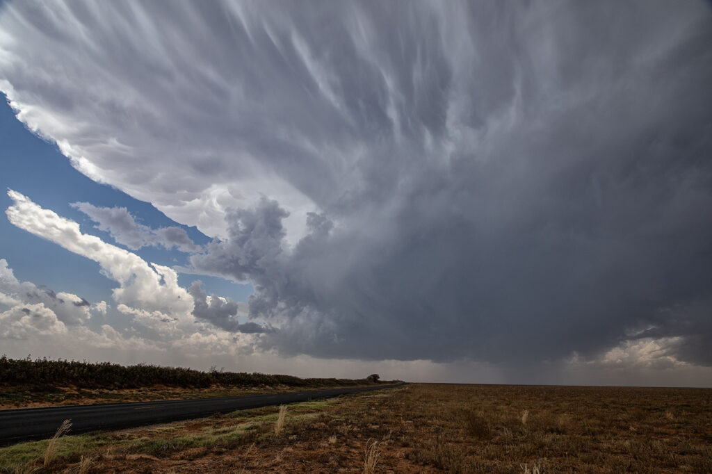
May 30th West Texas Supercells
May 30th brought an interesting chase. A sharp dryline and an outflow boundary would intersect over west Texas and provide the focal point for severe weather. Storms formed at the triple point but could not sustain themselves for very long as they moved out into more stable air. We ended up dropping south from Morton, Texas to Denver City, Texas as one storm formed, hooked hard and tried to produce. In the end the only storm that produced was near Midland, Texas as it dropped two substantial tornadoes. Our storms looked good, but due to a bit higher cloud bases, they could not get a circulation down to the ground. Overall a fun day but a bit frustrating as we were so close but not close enough with our storms.
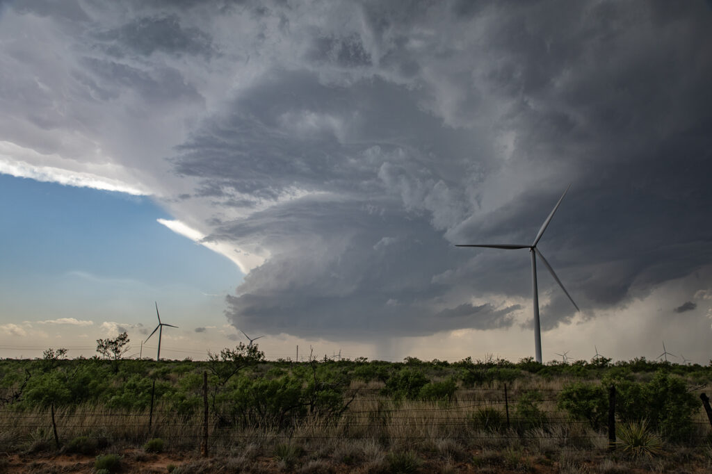
May 28th Morton, Texas Supercell with HUGE hail
May 28th set up had a dryline in west Texas, with strong southeast winds bringing modest moisture westward. Moderate CAPE developed as well and storms formed mid afternoon along the dryline. Storms pulsed quite a bit, and due to straight hodographs, storms split and many mergers occurred. Eventually a supercell developed, anchored near Morton. Structure became better, but due to modest moisture, the cloud base was too high to produce tornadoes. As it moved east it encountered a boundary and spun nicely. After several cycles, it produced 5 inch diameter hail west of Lubbock! We blew it off as it weakened and played further south with a supercell that had softball sized hail. The tornado threat this day was quite low due to high bases, but with strong shear in place and low freezing levels, storms were prolific hail producers.

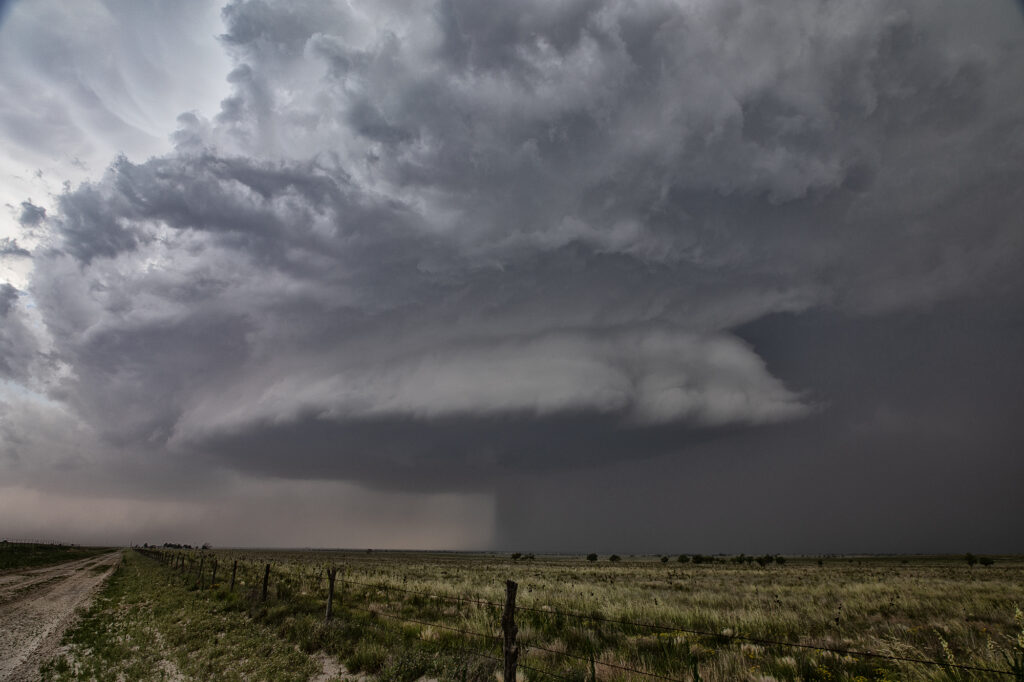
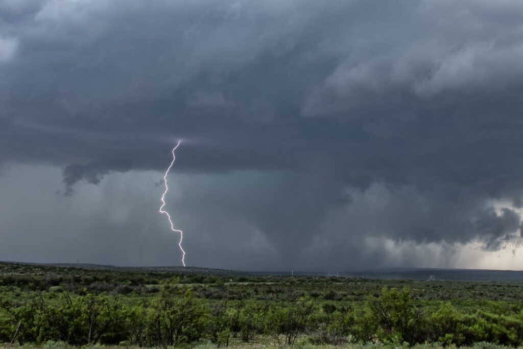
May 4th Davis Mountains Tornadic Supercell
Even though May 4th was the last day of the tour, we could not pass up the chance to chase the set up this day. Upslope flow, good moisture and instability, along with good shear provided the needed ingredients for supercells and potential tornadoes this day. We knew storms would start out high based, but their bases would lower as they moved east off the mountains into the lower lands where better moisture resided. That is exactly what happened. A cluster of storms formed, of which the tail end cell took over and became dominant. A quick spinup occurred as low level rotation cranked up under the updraft We had to vacate our position due to huge hail falling and drove east of Ft Stockton to a south bound road that would be give a view. The only issue is there just aren’t many roads in this part of Texas. As we drove south, rotation increased as the supercell dropped a rather large cone. It became rain wrapped after a few minutes so we continued southward to where the road put us directly in front of the supercell. Soon cgs started raining down from the updraft and rotation became focused. Several tornadoes formed and rotated around the wall cloud. It was quite the sight!!! After becoming strongly HP, we blew it off since we had a 600 mile drive back to Oklahoma City that night. 3 am arrival, but everyone was stoked due to the excellent day we had! Enjoy the pics!
May 3rd Southwest Texas Tornadic Supercells
May 3rd kept us in southwest Texas near San Angelo and vicinity. Strong instability, good moisture, high CAPE ad decent shear would set the stage for several supercells. A tornado occurred near Silver, Texas early on as we tried to get over to the supercell. Due to one lane roads and closed roads, we could not make it in time, so we dropped south towards San Angelo and played another supercell that had formed and anchored on a boundary east of Town. It had a very pronounced clears slot with rapid rotation in the mesocyclone, and dropped a quick brief dusty tornado. As we pushed east near Eola and watched couple brief landspout tornadoes. RFD was wrapping hard to our north and we decided to explore it. A big bowl formed with tons of blowing dirt, and eventually a brief tornado occurred. Soon numerous storms exploded and things became messy and outflow dominant. At this time, we decided to get away from the mess and call it a day. Fun day, a bit frustrating due to closed roads, etc, but another day with supercells and tornadoes is always a good day! Enjoy the pics!


May 2nd Hawley, Texas Violent Tornado
May 2nd featured a weak boundary in central Texas that would be the focus for storm development late in the day. Numerous storms formed along the boundary. Due to shear profiles, storm splits and mergers were evident. By mid to late afternoon a few storms formed along highway 277 north of Abilene, Texas. One split happened that passed in front of a right moving supercell near Anson and caused it to increase rotation rapidly. West of Anson a tornado touched down and was on the ground for a few minutes. As the old occluded mesocyclone weakened and dissipated, another one formed to the east/southeast of the first one. Soon rapid rotation occurred and eventually led to a small funnel. The funnel ascended and descended several times before it finally touched down northwest of Hawley. As the tornado firmly planted, a debris cloud formed. The tapered tornado widened into a text book drill press type tornado, with its strongest winds at ground level. The waterfall sound of the roar of the tornado was quite audible as it churned towards highway 277. Unfortunately it hit a couple houses, levelling them in its wake. The tornado then moved southeast and dissipated. All in all it was on the ground for over 20 minutes. The damage it causes was sporadic, but was rated high end EF3.
A great chase day, but with sad results due to the destruction the tornado caused. You NEVER want to see that happen anywhere. Fortunately the NWS in Abilene was able to give advanced warning to local residents, which resulted in no fatalities, but a few injuries did occur. Our thoughts and prayers to go to those families who were affected by this violent tornado.

April 23rd Sweetwater, Texas High Based Supercell
April 23rd promised some decent severe weather opportunities. However due to lack of good moisture, storms were high based. We intercepted one storm northwest of Sweetwater and stayed with it all the way south of Abilene where it gusted out. Structure was pretty and the hail up to golfball sized. It was also a pretty decent lightning producer. As it reached maturity and started weakening an haboob developed spewing red dirt all over. Winds were gusting over 70mph. All in all a decent day for the ingredients available to produce intense storms. Enjoy the pics!

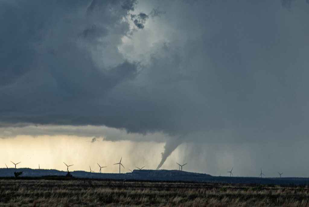
June 13th Texas Panhandle Tornado Warned Supercell
June 13th took us to the northern Texas Panhandle for supercells. By mid afternoon, storms for along the TX/OK panhandle border area near Boise City, OK. These storms moved slowly southeast and became supercells. Hail and high winds were the common theme with these storms, then southwest of Guymon, OK one became tornado warned. It didn’t produce but certainly tried as a funnel descended halfway to the ground. Never could confirm if it touched down or not. As the storm moved further southeast towards Stratford it did produce a small cone for a couple minutes. We were blocked by the police from getting close, so we had to drop south and east to get ahead of it. It was constantly tornado warned but had that outflow dominant look to it. We eventually stayed ahead of it to McLean, Texas and let it pass overhead. It produced giant hail 5 inches in diameter, and you’ll see in the pics just how huge it was! Fun day, but wow there were some fake tornado reports!