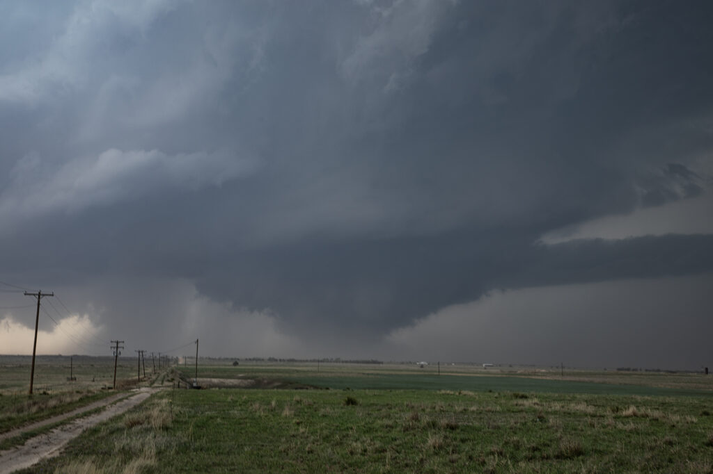
April 26th featured an upslope/dryline play in eastern New Mexico. Storms formed along and north of an outflow boundary. We intercepted the triple point storm that developed just northeast of town and kept back building at the triple point until it got so strong it moved southeast along the boundary. It didn’t take long in the highly sheared environment for it to start rotating strongly. Inflow winds of 50 mph fed the storm. There was so much dirt being sucked into the updraft at times, you could see the dirt cloud rise into the updraft base. Eventually the low levels started rotating as a very obvious mesocyclone formed. A clear slot wrapped around the meso and a long snaking elephant trunk shaped funnel, then tornado descended from cloud base. Dirt partially obscured it from time to time and it dissipated after about 5 minutes. The storm was a prolific hailer as ell we 3-4 inch stones reported. We stay with it until dark when it weakened. A fun day and a major powerful supercell was incredible to experience from birth to death. Enjoy the pics!
April 25th Muleshoe, Texas Tornadic Supercell
The arrival day for Tour #1 took us on an impromptu chase to west Texas. I knew it was a long way out and the we may or may not make it in time. We blasted west of Plainview just as the one decent (but short lived) tornado formed and dissipated. We arrived near Muleshoe to insane inflow winds into the supercell. Multiple wall clouds formed over the next 3 hours, but it just didn’t have that look. Areas of rotation formed, but never could tighten up enough to produce another tornado. The supercell persisted for many hours and was a prolific hail storm with stones up to 5 inches in diameter!!! Typically on arrival day, we restrict the chase within the state of Oklahoma, but this one was an exception, In the end, everyone enjoyed it, but a long way to go for what ended up transpiring, however it was tornado warned for several hours. Enjoy the pics!

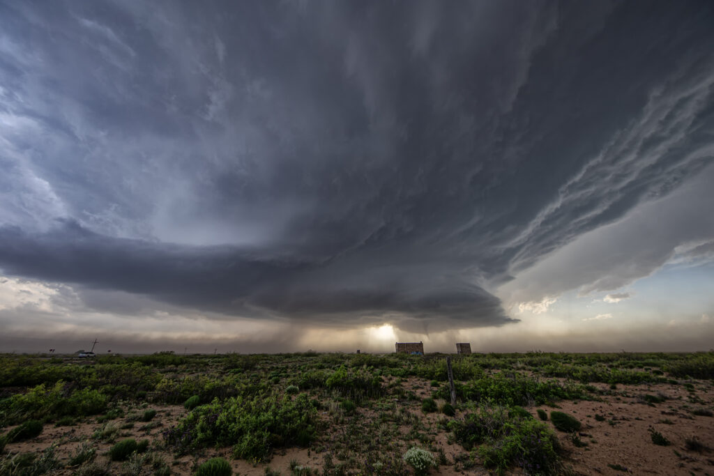
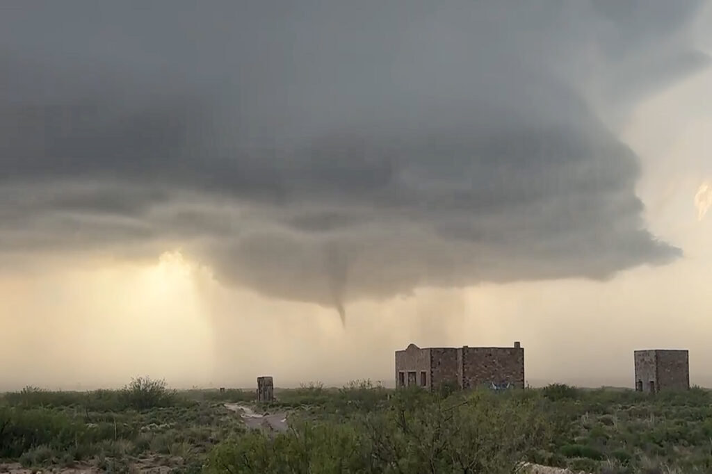
April 24th, 2025 Matador, Texas Tornadic Supercell
What a day April 24th was!! There was a high threat for supercells and if one could latch on to a boundary in place it had the potential to produce tornadoes. Strong shear, great moisture for late April standards, and good instability were all present. I headed down from Woodward to the Texas Rolling Plains. When I arrived, a supercell had formed and started spinning hard not far from Silverton. As I approached it from the east at Turkey, I encountered baseball sized hail and dropped south to get out of it. I set up my camera and soon an elephant trunk shaped tornado formed. It planted firmly for about 10 minutes before dissipating. Soon the storm started reorganizing and I dropped south to just north of Matador. It cycled and developed a wall cloud, then a bowl and then a multivortex tornado. That turned into a huge cone, then close to a wedge before becoming rain wrapped. It was on the ground for probably 25-30 minutes!! After that the storm became quite HP and, having to be back in Oklahoma City that night, I left it and proceeded back to our base city. An amazing day, structure, 2 tornadoes, huge hail and lightning. Enjoy the pics!

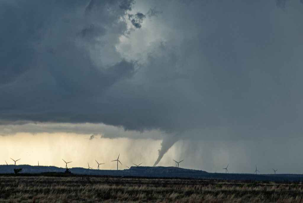
April 19, 2025 Mertzon, Texas Tornado
April 19th was a long drive. Up at 4am to hit the road, we blasted nearly 700 miles, only to miss the best tornado of the day by 20 minutes. Talk about frustration! Models/NWS/SPC stated the tornado threat wouldn’t ramp up until after 6pm when the low level jet kicked in. All were wrong! Before 4pm a supercell hit the boundary and became tornadic. By the time we arrived, that storm had weakened so we targeted another supercell west/northwest of San Angelo. It also became briefly tornadic as the main meso wrapped up and dropped a cone funnel to the ground! It was only down a couple of minutes before lifting back up. A long drive, but we at least were able to capture a tornado!


April 2-4 Arkansas, Tennessee and Texas Tornado Warned Supercells
We ran an on call storm chasing tour in TN/AR/TX during the April 2-4 period. We caught numerous tornado warned supercells, however on the Lake City, AR day (4/2), we debated whether to play west of the MS river or east. (Very few crossings!) Parameters were pretty sweet. We ultimately chose east (ugh) due to several discrete cells and at that time nothing west of the river. Sooo, no tornado for us! Chased a half dozen tor warned storms, but nothing produced in TN, till after midnight of course.
Second day we chased southwest AR/NW LA. Storms formed southwest of us (Ida, LA) and became tor warned. As they approached and crossed the front into wet, cool, stratus filled skies that was the end. Elevated for certain.
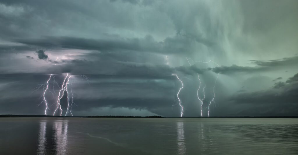
Last day (4./4), after spending the night in Texarkana, we stayed close. We were torn between the ne TX play or venturing up towards Little Rock as models were producing isolated supercells ahead of the front. We started towards Little Rock (Thinking of the Lake City event and hoping for Part 2!) and turned back around as several supercells emerged out of junky clusters in northeast Texas. We managed to catch one tornadic supercell between Texarkana and Douglassville, TX. A couple tornado reports came across, but appeared to be buried back in the Rear flank core around the hook. We found a spot by a lake as the storm approached. It was INSANELY electrified. You could see a VERY low wall cloud (possible messy circulation?) that persisted for many minutes before CGs hitting on the other side of us ran us back in to the van.
Fun trip, a bit disappointing that we didn’t catch the Lake City tornado, but you have to make choices and with several developing supercells east of the river, there was no way we were staying west. Even SPC’s MD hit western TN the hardest. Funny thing, we actually drove through Jonesboro and Lake City coming down from Springfield, MO that day. Ironic as can be…….