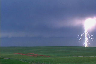
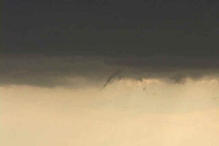
Limited moisture would destroy the possibility of a significant tornado on this day. Wonderful wind shear would be enough to get a couple intense supercells developing. One such storm developed in southeast MT and moved into western South Dakota. This supercell did everything it could to produce a tornado, but could not. However it did exhibit impressive structure. As night fell in South Dakota, this storm became an electrified monster.
July 7th, 2003 Ogallala, Nebraska Windstorm
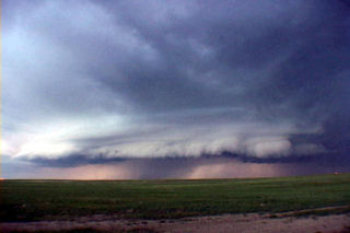
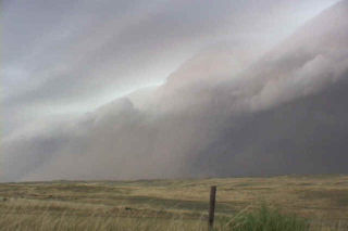
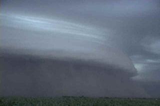
This day would prove to be a rather interesting day. Several storms developed in eastern Colorado and merged into on very large bow echo as it approached Nebraska. Wind gusted to over 100 mph and caused considerable wind damage. Trees were down, as well as power outages and minor structural damage. One thing for sure was that the shelf cloud that formed with this system was quite impressive.
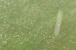
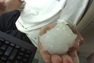
July 2nd, 2003 Elbow Lake, MN Hailstorm
July 2 took me to the northern plains to chase a supercell in western Minnesota. Conditions were not favorable for tornadoes, but cold air aloft and good mid level flow would prove enough for rotating supercells producing very large hail. One such storm hit the Elbow Lake, MN area with 5″ diameter hail. I was fortunate or unfortunate enough to experience this supercell personally.
June 24th, 2003 South Dakota Tornadofest
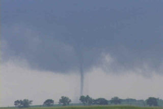
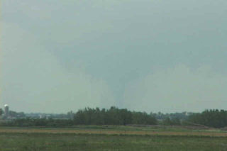
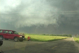
Some days you never forget. This day was to be one of those days. I spent the night in O’Neill with my tour and my fiancé Caryn who had yet to see a tornado. This was to quickly change. Morning analysis showed a well defined boundary along the NE/SD border extending east/west. This boundary slowly drifted northward into South Dakota by early afternoon, as did we. Cells started developing west of me in the hot air, but we waited patiently near Pickstown, SD. By 3 PM, it was evident we needed to go north to near I-90 and the Mitchell area. As we drove north, a supercell rapidly developed just west of Mitchell. By the time we could get the base into view, a huge block wall cloud was visible. Soon, a large cone tornado formed west of Mitchell, south of I-90. We approached the tornado to our north, but were a good 10 miles from it as it roped out, while another weaker tornado formed after the occlusion to the east. By the time we reached updraft base, the show was over. But we did manage to catch a couple decent views of both tornadoes.
Next, I noticed an explosive updraft northwest of town. We raced northwest towards the town of Woonsocket and as we approached a truncated cone tornado formed. This tornado morphed into a large stovepipe, then elephant trunk, then stovepipe again as we watched from 1.5 miles east of it. A GORGEOUS tornado to say the least. After 12 minutes, it dissipated. The occluded updraft died, as a new meso formed to our northeast. However, now the road options were pathetic with only dirt and gravel roads to use to keep up with the storm. As we zigzagged across the countryside northeast of Woonsocket, another supercell was developing farther to our east. It quickly dropped twin tornadoes about 8 miles east of us. We decided to abandon our efforts on our shriveling storm and go after this intensifying tornadic supercell south of Iroquois, SD. As we maneuvered muddy dirt roads, another tornado formed under the new storm. This nice rope tornado was about 5 miles to our east. As we got closer, now about 6 miles south of Iroquois, a multivortex tornado formed along with a small satellite tornado. What a sight!!!!!!!
I decided to get the tour closer, so we raced up to Iroquois, then east of highway 12 toward Manchester and DeSmet. I knew we would have to punch the hook of the storm and warned everyone what we could find as we punched it. Sure enough, just west of Manchester a VERY LARGE tornado had just crossed the road about 300 yards in front of us. This tornado was very violent. As it ripped the town of Manchester apart, we sat in awe as the tornado dropped tons of debris all over the countryside. It moved north of Manchester and continued to be a violent tornado (rated F4) as it went through a long rope stage. Finally it roped out as we decided to head towards DeSmet. Another multivortex tornado quickly formed after yet another occlusion and stayed on the ground for 4 minutes. Finally, northwest of DeSmet the last and very photogenic tornado occurred and last nearly 15 minutes!!! What a day!!!!!
June 11th, 2003 Lyman, SD Supercell
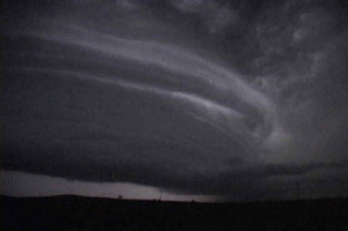
June 11 took me to South Dakota for another promising day. The conditions this day were similar to June 9 which produced several tornadoes, however the models were consistent in bringing a bit less moisture to the region. This would be the big factor this day in my mind why we did not get a tornado to form. Cloud bases were too high for any significant tornado development. However the storm was a beautiful supercell and had wonderful structure. It produced 3″ diameter hail, several funnel clouds and intense lightning.
June 9th, 2003 Northeast Nebraska Tornadoes
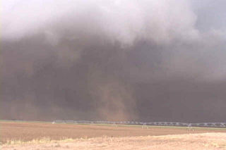
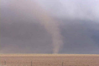
June 9 was to be one of those unforgettable days. Strong shortwave energy approaching from the west was to interact with a warm front boundary in northern Nebraska where rapidly increasing moisture would help provide the fuel needed to spark severe thunderstorms. By late afternoon a thunderstorm developed near Springview northwest of O’Neill. This storm went on to produce at least 3 confirmed tornadoes over the next several hours. Two of these tornadoes were photogenic with the final one north of O’Neill being a large dusty multivortex tornado. Pics of these tornadoes are shown below in the order that they occurred. Enjoy!
June 5th, 2003 New Mexico Gustnadofest
Not a great set up this day as storms formed north of an advancing cold front. These storms had embedded supercells in a line and they produced many photogenic gustnadoes. One such “spin up” actually had cloud base rotation and would be considered a weak tornado. Later, as the haboob formed, a large wall of red dirt was seen from many miles away.
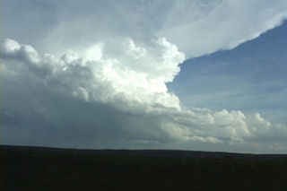
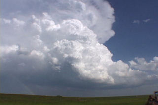
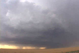
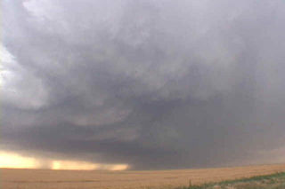
June 4th, 2003 Quay County, NM Incredible Supercell!
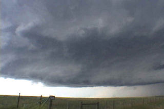
June 4 was to be a day I would not soon forget. Northwest flow aloft would be the set up for this day. A nice highly striated supercell developed near Raton, NM and tracked due south along the foothills. This storm was very hard to stay with as the road network was not conducive to a successful intercept. However I was able to catch it and take some pretty video of this nearly 2 hour tornado warned storm. The next beast that I will not soon forget developed south of Tucumcari and tracked southward along an outflow boundary. This supercell, also tornado warned for several hours did not produce a significant tornado, however it did have INCREDIBLE structure, phenomenal 60 mph plus inflow and hail baseball size that destroyed my windshield. Check out the photos below of this beast. The first photos are of the first supercell.
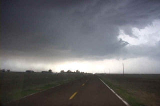
June 3rd, 2003 Texas Panhandle Supercellfest
The set up on June 3 was one of a strengthening dryline in the Texas Panhandle with very strong instability. Thunderstorms developed late afternoon near the town of Friona and continued to blossom during the evening. There were several weak tornadoes, large hail reports and beautiful storm structure. If dewpoints had been a few degrees higher this could have been a very explosive day.
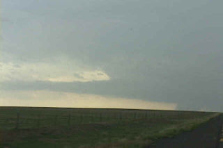
May 18th, 2003 Limon, Colorado High-based Supercell
On a day when there was not much hope, I caught a high based supercell near Limon, Colorado. This storm formed off the Palmer Divide and produced baseball sized hail and 70 mph winds. The set up was not great with modest upslope flow, 50 Tds and weak shear. Check out the photos below for structure of this storm. It also had a respectable looking shelf cloud and an attempt at a wall cloud in the notch of this supercell.