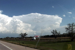
Since April 20th was my birthday and there was a respectable chance for severe storms, Caryn and I headed out on i-76 towards Imperial, Nebraska to play the strong upslope flow with good shear, but marginal moisture. Dewpoints were expected to increase as the evening progressed, but what we ended up with was much more than I had planned on! A couple of LPish type storms developed around 6 PM and then just before dark, a tornadic beast emerged from the tail end of the complex and produced several tornadoes that caused considerable damage between Moorefield and Gothenburg.
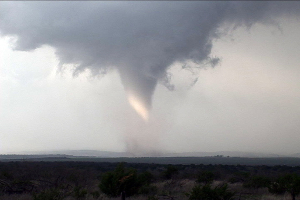
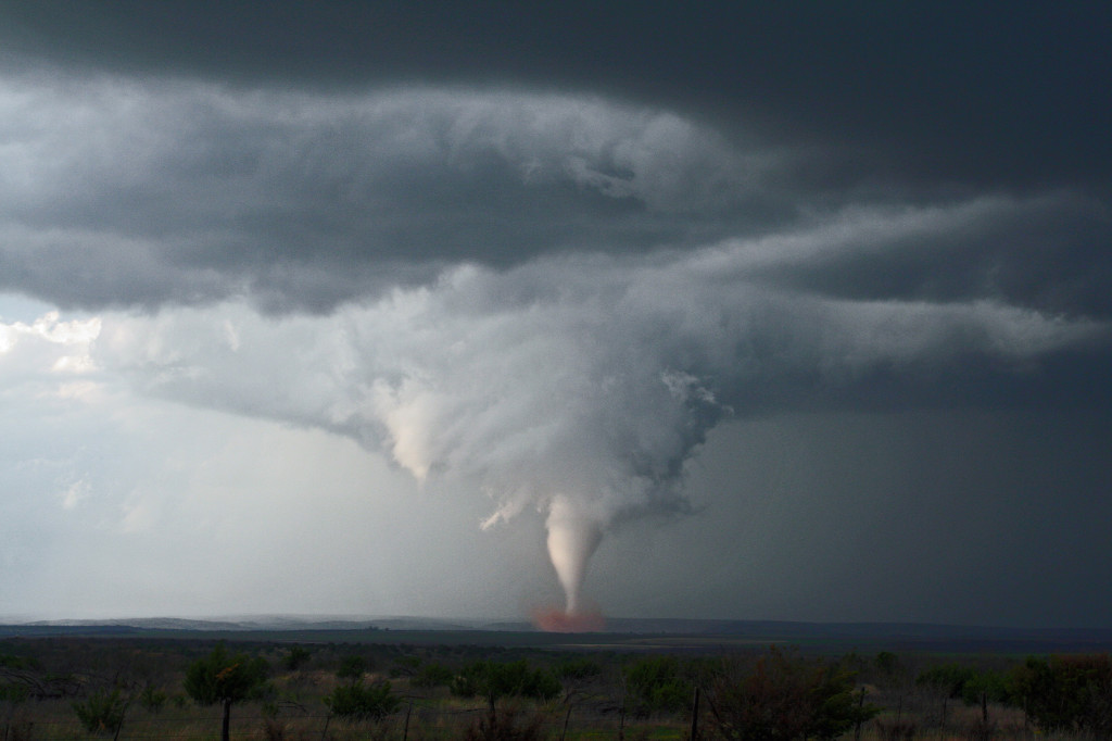
March 28th, 2007 Texas Panhandle Tornado Outbreak
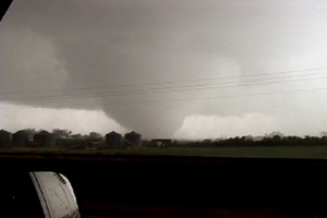
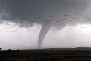
March 28th was a day many storm chasers will never forget. An unusually strong and deep system was crossing the Rocky Mountains with intense lift, deep moisture, incredible shear and good instability headed towards the southern and central high plains. This would set the stage for what would become one of the most prolific tornado days in the high plains ever recorded in March. All in all I caught 8 tornadoes this day with 3 being quite photogenic and quite strong. A total of 65 tornado reports were submitted to SPC. Two different supercells spawned killer tornadoes. I have many still photos and a few video captures of the tornadoes we intercepted below. The first two tornadoes we could not get photos of as they were too far off near Silverton, Texas. We were on a hard intercept course for that supercell and couldn’t get there in time to get good photos. Both tornadoes were slender elephant trunk shaped tornadoes. Then a 3rd tornado formed, a multivortex tornado, northeast of Silverton and that is where my first video capture was taken. After that supercell moved northeast, the developing tail in storm became quite a dominating monster. We caught 3 or possibly 4 tornadoes from that storm. Finally, as that cell moved northeast towards Miami, Texas, we could see a lightning lit very large wedge tornado to our distant north. This final tornado derailed a train and did some minor damage.
March 23rd/24th, 2007 Eastern Colorado and Southwest Nebraska Storms
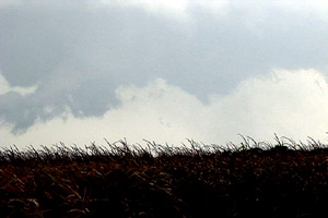
A strong closed low was to be the culprit for sever weather across Colorado and Nebraska on March 23rd and 24th. the most intense storms and tornadic supercells developed over eastern New Mexico, while Colorado just didn’t have enough deep moisture to get intense storms to form. Marginal supercell structures formed and were quite photogenic. On the 24th, poor lapse rates and marginal moisture would spell doom for what appeared on paper to be a decent set up. A couple of tornado occurred in northeast Colorado on Saturday, with a possible brief tornado near Hayes Center, Nebraska.
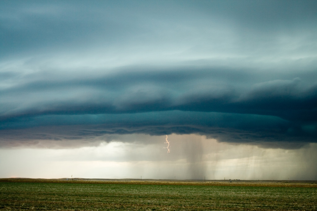
March 10th, 2007 Claude, Texas Hail and Anvil Crawlers
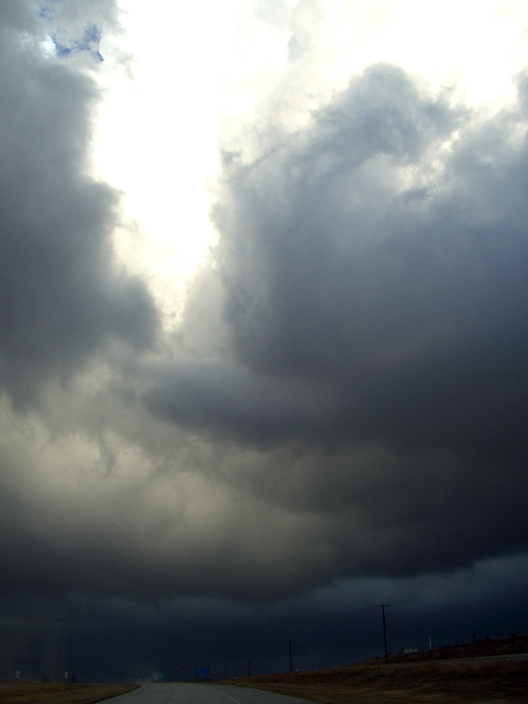
March 10 appeared to be a marginal day for severe weather across the Texas panhandle. With nothing else to do, I decided to head south from Denver to see what would form. Limited moisture was the main problem, but very cold air aloft and decent wind shear would help to produce several high based supercells this day. Many of them produced hail quarter size, with up to ping pong ball sized reported with the storm featured here. Near dark as the cells merged into a southeast moving MCS, the anvil crawler show began.
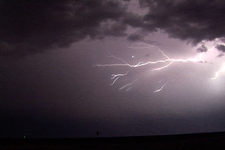
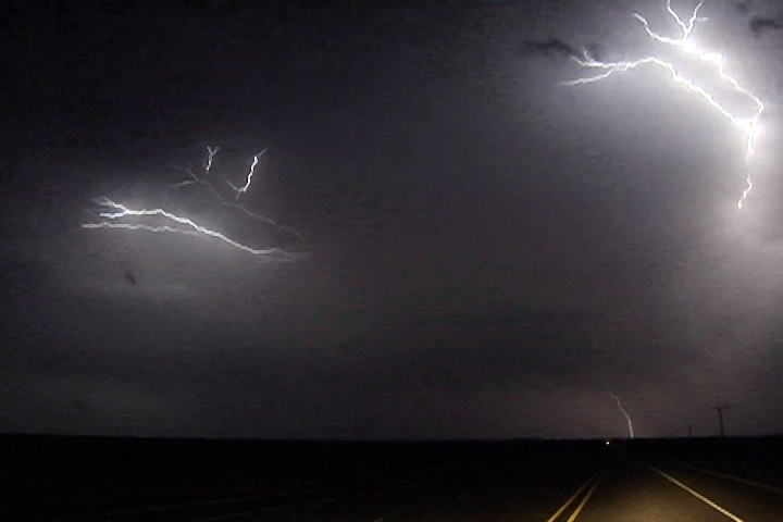
February 23rd and 24th, 2007 Texas Panhandle and Central Kansas Supercells
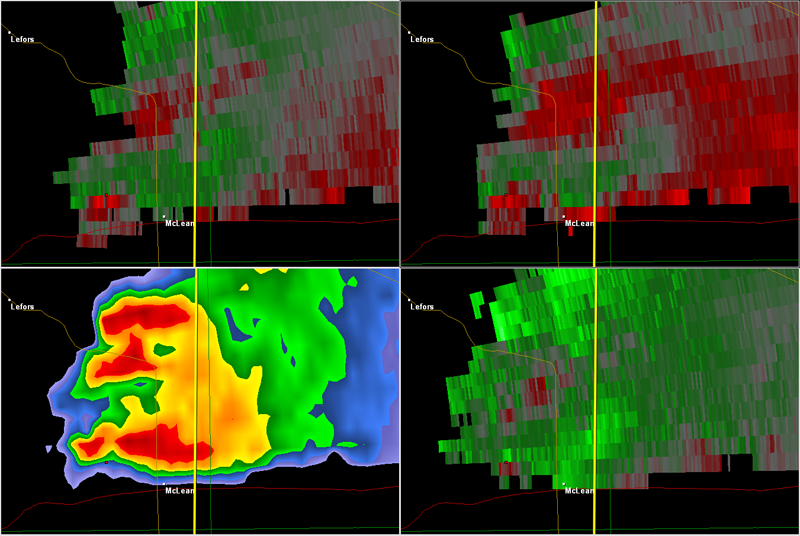
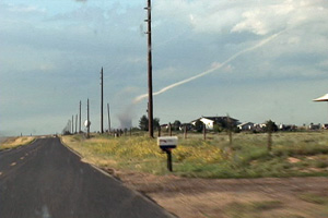
I can’t believe the 2007 chase season has started for me. The models had shown a great potential pattern for this two day period for several days, so I couldn’t resist heading out to clear the wintertime cobwebs from my head. On the early morning of February 23rd, I picked up Jon Merage, who owns the copyright to some of these photos (web.mac.com/mistertwister), two SLT Local customers, and off we went. My target was the Texas panhandle east of Amarillo. Everything showed the dryline sharpening up there, along with decent moisture and great shear. We arrived to see shallow cumulus towers developing on the dryline and soon the first weak cbs developed. Several storms formed southeast of Amarillo, with each one getting stronger with each successive attempt. A tornado watch was soon issued. Finally a few weak supercells developed. At 5:50 PM one storm approached I-40 near McLean and produced an 11 minute long tornado, that skipped along the ground, occasionally making contact and producing a dirt/debris cloud. As the tornado roped out, my van blew an oil line (that had JUST been replaced!), and that finished our evening. After having the van towed back to Amarillo to a Ford dealer we rented an SUV and continued our chase.
February 24th looked like a decent cold core chase in Kansas. By late morning we arrived in the Wichita area and around 11:30 a tornado watch was issued. You could see serious convection developing along the dryline/pacific front intersection and see the towers moving northwest and intensifying. We headed north from El Dorado to the Florence/Marion area as a tornado warning was issued. A tower directly in front of us was quite low and rotating wildly. A nub funnel appeared, but never did touch down. We continued north with the storm and then drifted northwest towards Abilene. Several low topped storms developed, with a couple becoming severe and even tornado warned. We headed west on I-70 to Solomon as a very low based storm developed. It was right on the boundary with the now occluding low and tried everything it could to produce a tornado. Numerous funnels developed and extended halfway to the ground. At one point we were under the shear line of this cell and directly in front of us winds cranked up quickly out of the west. Directly north of that, winds were crazy out of the east. Tumbleweeds, corn stalks and hay were pulled up into the air! We think there was a weak tornadic circulation on the ground! Directly overhead there was strong cyclonic rotation with a rotating lowering/funnel! Shortly afterwards the cell weakened as it moved into the cold air. We ended up spending the night in Salina as all roads back into Colorado were closed due to blizzard conditions.
September 15th, 2006 Nebraska Tornadic Supercell
September 15th was in my opinion a classic “day before the big day” scenario over south central Nebraska. Adequate shear and lift were available, but quality low level moisture return was the main problem. By later afternoon storms exploded near Holdridge. Several supercells would form and move quickly northeast at 40 MPH. One storm developed near Hastings and tracked northeast producing a 4 minute long tornado about 5 miles south of I-80. This storm also produced hail golfball to tennisball sized.
August 24th, 2006 South Dakota Tornado Outbreak
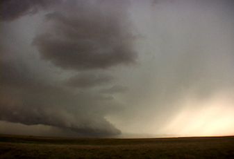
What an event!! After watching model run after model run I couldn’t resist the 1700 mile round trip to eastern South Dakota from Denver to chase this one!!! I arrived in Sioux Falls, SD around 3 PM. I couldn’t decide whether to sit tight, head to southern Minnesota or head west towards the advancing front. Each situation had its positives and negatives. After much analysis and some very quick driving, I decided to head west towards the front, which now was firing a string of supercells along it. I targeted the southern supercell coming across the Missouri river north of Pierre. I caught up with it east of Oneida and what a sight it was!!! It took about 10 minutes for it to drop its first of 7 tornadoes that I saw. The structure was second to none as this beautiful striated updraft produced one tornado after another. The largest and strongest tornado developed southwest of Wessington and tracked southeast near Wolsey to southwest of Huron before dissipating. It stayed on the ground over 40 minutes and resembled the Manchester, SD tornado from June 24, 2003 (which I saw from the south side). Finally, the storm produced one last tornado southeast of Huron as it weakened moving towards I-29.
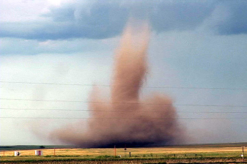
August 20th, 2006 Bennett, Colorado Tornadoes
I wasn’t planning a chase this day. However, as the afternoon progressed an outflow boundary raced south from convection in Wyoming, and intersected the DCVZ boundary that was quite evident running from Bennett to Prospect Valley, Colorado. Good instability, weak shear and the boundary would provide a perfect set up for non-supercell (landspout) tornadoes! And the atmosphere didn’t disappoint! By 5 PM a VERY nice line of towers exploded along the boundary. By 6 PM I had seen 3 funnels. At 6:37 PM the first tornado touched down 4 miles north of my house. It stayed on the ground for 20 minutes before dissipating. The second tornado touched down at 6:54 PM and stayed on the ground for 9 minutes. It was much larger than the first, but outflow from the downdraft of the first cell would kill this tornado much sooner than the first one. At one point in time both were on the ground !
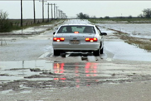
August 30th, 2006 Eastern Colorado Hailstorm
August 30th showed some potential for initially high based convection to get better organized as it moved east off the Palmer Divide into better moisture. That is exactly what it did. Nice upslope flow underneath 30-40 kts mid level westerly flow would provide strong enough shear for storms to become supercellular and produce large hail. Several storms developed on the eastern side of Denver, then most east into a line. However the tail end storm, as is often the case, became a nicely rotating supercell that produced hail to golfball sized. The structure was very nice with HP type characteristics. As the storms approached the Kansas border the dissipated.
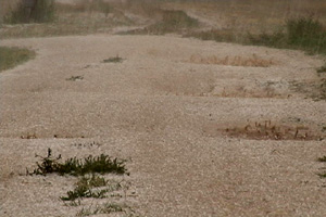
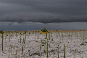
August 18th, 2006 Lincoln County, CO Hailstorm
August 18 looked like a fairly marginal day for supercells. However, a deviant moving storm developed south of Limon, CO and moved southwest enhancing its shear to the fullest extent. This storm produced COPIOUS amounts of hail over southeast Lincoln county that destroyed every crop, tree and building in its path. Hail fell for about 40 minutes and ranged in size from quarter to golfball.