
August 24th, 2006 South Dakota Tornado Outbreak
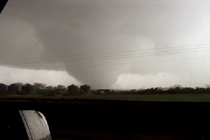
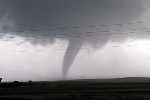
What an event!! After watching model run after model run I couldn’t resist the 1700 mile round trip to eastern South Dakota from Denver to chase this one!!! I arrived in Sioux Falls, SD around 3 PM. I couldn’t decide whether to sit tight, head to southern Minnesota or head west towards the advancing front. Each situation had its positives and negatives. After much analysis and some very quick driving, I decided to head west towards the front, which now was firing a string of supercells along it. I targeted the southern supercell coming across the Missouri river north of Pierre. I caught up with it east of Oneida and what a sight it was!!! It took about 10 minutes for it to drop its first of 7 tornadoes that I saw. The structure was second to none as this beautiful striated updraft produced one tornado after another. The largest and strongest tornado developed southwest of Wessington and tracked southeast near Wolsey to southwest of Huron before dissipating. It stayed on the ground over 40 minutes and resembled the Manchester, SD tornado from June 24, 2003 (which I saw from the south side). Finally, the storm produced one last tornado southeast of Huron as it weakened moving towards I-29.
No comments yet.