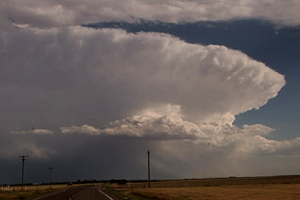
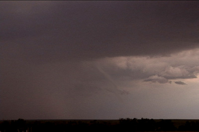
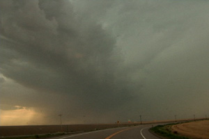
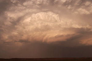
July 20 promised to be a day with decent shear, instability and moisture, with a strong wave moving southeast out of Montana late in the day. Morning cloudiness cast a doubt on anything decent happening, but by noon, the mid level clouds eroded and good surface heating commenced. It didn’t take long for storms to fire up, and this storm became the storm of the day, producing tennisball sized hail, at least two funnels and intense lightning. It developed along I-25 south of Chugwater, WY and dissipated along the WY/NE border. It was one of the prettier storms of 2006!
July 17th, 2006 Eastern Colorado Severe Weather
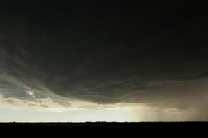
July 17 featured a persistent boundary across eastern Adams, Arapahoe and Elbert counties in Colorado with deepening moisture on easterly flow. Shear was marginal, but with the boundary in place and strong instability, storms developed along the boundary and two of them spun pretty strongly, causing the NWS to issue tornado warnings on them. We caught them as the intensified and produced a couple of funnels, although we never could confirm touchdown. The one pictured above appeared to be anticyclonic as it formed on the south side (looking west) of the clear slot of this rotating storm.
July 13th, 2006 Greeley, Nebraska Supercell
July 13th had a great set up potential for Nebraska. Strong shear, a nice boundary and mid 70s dewpoints would all come together and produce a nice supercell in north central Nebraska. I came from Grand Island north to catch it. SPC mesoanalysis page showed the best of the best conditions feeding into that storm! (I just couldn’t go for the elevated trashy crap heading towards OMA) I sat just south of Greeley to watch it before heading west towards Ord. I was looking west at it, and it had a nice soda can/bell shape to it. Nice structure, tried to produce, but just couldn’t. Typical 2006. The core had solid 1.5″ to 2″ diameter hail from it. I also encountered winds gusting to 82 MPH (measured!) not far from Greeley when it gusted out.
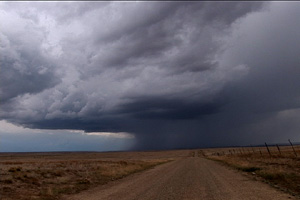
June 25th, 2006 Northeast New Mexico Surprise Tornado
The first day of my North Land Lecture Tour resulted in a “south land” weak tornado! What a surprise! We headed south from Denver and crossed the Raton Mesa, only to see what looked like supercell structure near Mt Capulin volcano. East we blasted and caught up to this cell as it produced a distant weak tornado!! What a surprise!! Later on, a weak LP type supercell formed near Springer and had decent structure for awhile.
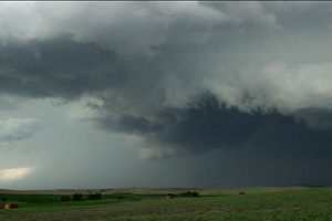
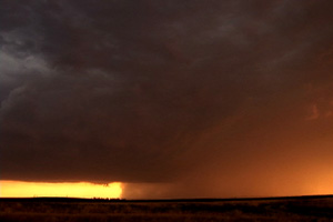
June 23rd, 2006 Northwest Nebraska Tornadic Supercell
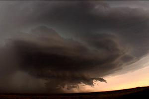
June 23rd was a day that had promise for high based storms in western Nebraska. It lived up to its potential and more! We caught the first supercell of the day that formed northwest of Scottsbluff and was a nice LP storm. The second LP storm formed northeast of Torrington and had very nice structure. And finally the storm of the day formed west of the Black Hills in northeast Wyoming and tracked southeast into northwest Nebraska. This storm had beautiful HP supercell structure and produced a couple of short lived tornadoes, one of which is shown below.
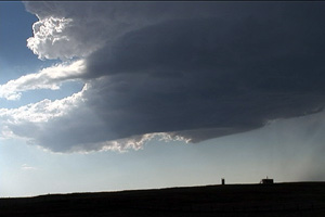
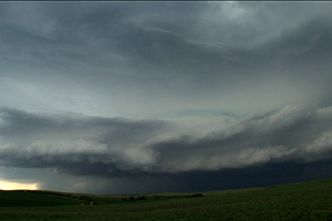
June 20th, 2006 Northeast Colorado Supercells
A few boundaries, good shear and adequate moisture would allow supercells to develop in northeast Colorado and western Nebraska. We first targeted a supercell and complex northeast of Alliance, but when we saw it was a left split we blew it off (mistake as it produced tornadoes!). The storms in Colorado were quite outflow dominant, except for the third supercell which was a respectable classic supercell near Yuma. The Colorado storms never produced tornadoes, but did have nice structure, lots of lightning and hail to baseball size.
June 14th, 2006 Crow Agency, MT Hailstorm
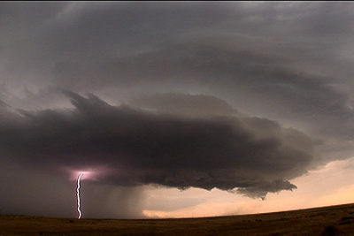
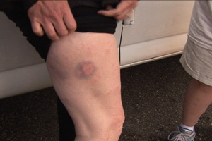
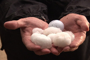
June 14 ended up being a disasterous day for us. The day started out with lots of promise as a strong wave was moving across the intermountain west with tons of shear. Moisture was fair and we expected some nice rotating supercells. We drove west of Broadus, MT in search of a new and intense supercell that formed west of Sheridan, WY and was tracking north. As we approached it near Crow Agency it bowed out and became a deviant moving storm. We tried to get back east to get ahead of it, but traffic soon stopped us as we took the brunt of this monster hailstorm. Wind of 95 MPH drove hail to golfball size into the vans and knocked out windows, injuring Caryn with flying glass and hailstones. After a quick trip to the emergency room, she was ok, but with tons of bruises.
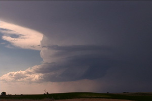
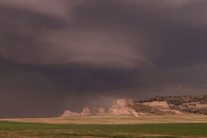
June 13th, 2006 South Dakota Badlands Supercell
I wasn’t expecting much this day, but couldn’t resist a play off the Black Hills of South Dakota. By mid afternoon a VERY high based supercell formed near Hot Springs. As it moved off the hills, it weakened and almost died. Then, not far from the western edge of the Pine Ridge Reservation, it intensified and became a wonderful high based hailer. The structure was as textbook of an LP as one could get. The most beautiful part was right at sunset as the sun lit the updraft and anvil, complete with reflected convection in the anvil.
June 11th, 2006 Scottsbluff, Nebraska Supercell
June 11 was the first day of tour 6. We debated on whether to stay in Colorado or head north. Surface flow and moisture was a bit better north into southwest Nebraska. And after a call from Dave Gold, north we headed. We arrived on the scene near the Scottsbluff National Monument to see a beautifully striated rotating supercell sucking dirt off the top of the monument. This storm did all it could to produce a tornado, even with a strongly rotating lowering on the northeast side of the storm. But it never could quite focus long enough to produce. However the structure was incredible!!!
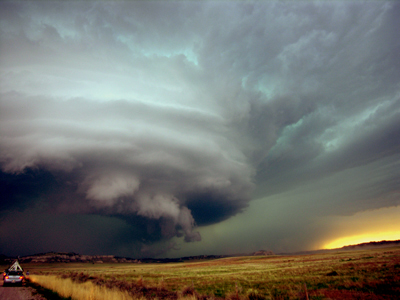
June 10th, 2006 Eastern Colorado Mothership Supercell
June 10 was a down day for Silver Lining Tours. However it was just too enticing to sit around as a severe storm developed along a boundary northeast of our house. We caught up with the storm near Last Chance, CO and stayed with it all the way to Burlington. This storm had fantastic structure with the beautiful “upside down wedding cake” look to it. However the tornado threat was nill as it was very high based. Nonetheless, it was a spectacular storm that produced hail to tennis ball size.