Tag Archives | May 2000

May 17th, 2000 Brady, Nebraska Supercell & Tornadoes

May 17 was another one of the unforgettable days as a tour guide for Silver Lining Tours. Most of Nebraska was under a moderate risk and the set up was promising for tornadic supercells. A strong low was parked over far southwest Nebraska with a warm front across the I 80 area. A dryline was pushing east and north which put the North Platte area in line for some great action. High based storms fired along the dryline in northwest Kansas by early afternoon.

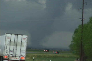
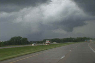
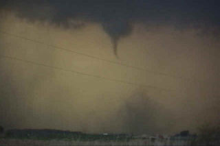
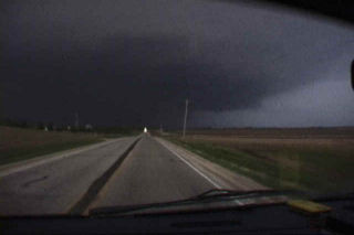
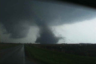
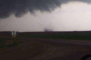
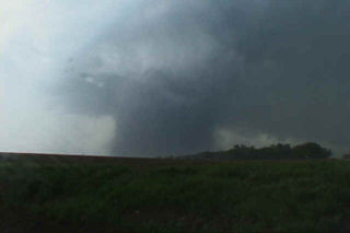
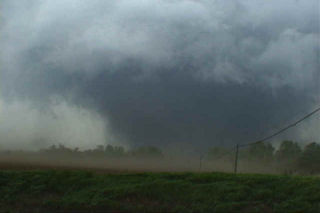
We waited near Lexington for the first cell to fire northeast of the dryline, and it did. This cell raced northwestward over Frontier county and produced our first tornado of the day (see photos below from Farnam). An LP supercell was just east of the first storm and really starting to look impressive as it tracked just east of the first storm. This was the storm that would produce the damaging Brady tornado. We quickly headed north to intercept the Brady storm which was now a gorgeous barber pole supercell. As we headed west on I 80 near Maxwell, a large tornado was visible just south of the Platte River. Pics of this memorable supercell, tornado and damage are below.

May 11th, 2000 Blackhawk County, IA Tornadoes

This page contains several more photos of tornadoes and storm structure from the Waterloo/Blackhawk county, Iowa tornadic supercell of May 11, 2000. After extensive review of my video, I have confirmed 7 tornadoes from this supercell. Images of all 7 tornadoes are contained on my Iowa pages. So, please check out all the pages, and enjoy!

May 11th, 2000 Dunkerton, Iowa F3 Tornado

This is the second damaging tornado from the cyclic supercell on May 11, 2000 in Blackhawk county, Iowa. This tornado formed to the southeast of the decaying original tornado and ended up damaging part of the town of Dunkerton. Unfortunately, Dunkerton had been damaged in 1999 by floods, and now was to suffer again only a year later. The tornado traveled in a northeast direction and clipped the western side of town causing up to F3 damage to some buildings.

May 11th, 2000 Waterloo & Blackhawk County, Iowa

The events that occurred on May 11, 2000 will be etched in my mind till I die. The incredible supercell that spawned at least 10 tornadoes that evening will go down as the single most incredible tornadic storm I have ever witnessed. This page will only contain the first of the tornadoes witnessed that day. The Dunkerton, Iowa F3 and those afterwards will be in the next 2 pages to come. This page is dedicated to the F4 wedge that barely missed the Waterloo area, but did cause significant damage, including injuries and one death on that date.

The set up on May 11 was iffy, but explosive. Everything was in place from a deep low in northwest Iowa, to surface temps and dewpoint in the 80s/70s respectively, CAPE values over 6,000, and good shear with strong backed surface winds. The main concern was an incredibly strong cap in place that would be difficult to break. At 6 PM CDT, a tornado watch was issued, and within an hour an explosive storm developed northwest of Waterloo. The photos that follow were taken from my Sony TRV900 digital camcorder. The closest shots were within 3/4 mile from this F4 killer tornado. Other stills will be added a they become available when I get my slides developed.