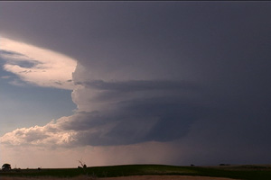
September 15th was in my opinion a classic “day before the big day” scenario over south central Nebraska. Adequate shear and lift were available, but quality low level moisture return was the main problem. By later afternoon storms exploded near Holdridge. Several supercells would form and move quickly northeast at 40 MPH. One storm developed near Hastings and tracked northeast producing a 4 minute long tornado about 5 miles south of I-80. This storm also produced hail golfball to tennisball sized.
August 24th, 2006 South Dakota Tornado Outbreak
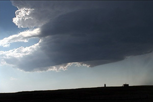
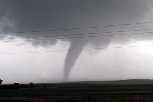
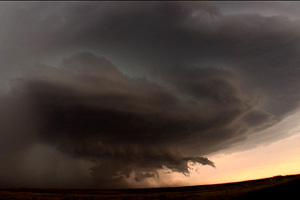
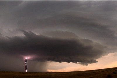
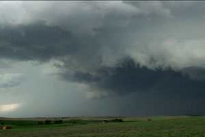
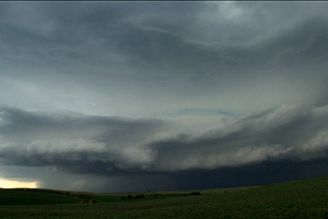
What an event!! After watching model run after model run I couldn’t resist the 1700 mile round trip to eastern South Dakota from Denver to chase this one!!! I arrived in Sioux Falls, SD around 3 PM. I couldn’t decide whether to sit tight, head to southern Minnesota or head west towards the advancing front. Each situation had its positives and negatives. After much analysis and some very quick driving, I decided to head west towards the front, which now was firing a string of supercells along it. I targeted the southern supercell coming across the Missouri river north of Pierre. I caught up with it east of Oneida and what a sight it was!!! It took about 10 minutes for it to drop its first of 7 tornadoes that I saw. The structure was second to none as this beautiful striated updraft produced one tornado after another. The largest and strongest tornado developed southwest of Wessington and tracked southeast near Wolsey to southwest of Huron before dissipating. It stayed on the ground over 40 minutes and resembled the Manchester, SD tornado from June 24, 2003 (which I saw from the south side). Finally, the storm produced one last tornado southeast of Huron as it weakened moving towards I-29.
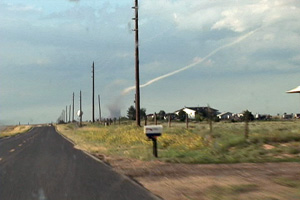
August 20th, 2006 Bennett, Colorado Tornadoes
I wasn’t planning a chase this day. However, as the afternoon progressed an outflow boundary raced south from convection in Wyoming, and intersected the DCVZ boundary that was quite evident running from Bennett to Prospect Valley, Colorado. Good instability, weak shear and the boundary would provide a perfect set up for non-supercell (landspout) tornadoes! And the atmosphere didn’t disappoint! By 5 PM a VERY nice line of towers exploded along the boundary. By 6 PM I had seen 3 funnels. At 6:37 PM the first tornado touched down 4 miles north of my house. It stayed on the ground for 20 minutes before dissipating. The second tornado touched down at 6:54 PM and stayed on the ground for 9 minutes. It was much larger than the first, but outflow from the downdraft of the first cell would kill this tornado much sooner than the first one. At one point in time both were on the ground !
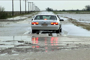
August 30th, 2006 Eastern Colorado Hailstorm
August 30th showed some potential for initially high based convection to get better organized as it moved east off the Palmer Divide into better moisture. That is exactly what it did. Nice upslope flow underneath 30-40 kts mid level westerly flow would provide strong enough shear for storms to become supercellular and produce large hail. Several storms developed on the eastern side of Denver, then most east into a line. However the tail end storm, as is often the case, became a nicely rotating supercell that produced hail to golfball sized. The structure was very nice with HP type characteristics. As the storms approached the Kansas border the dissipated.
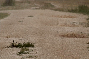
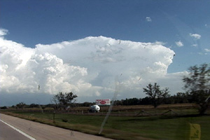
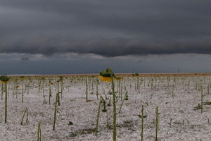
August 18th, 2006 Lincoln County, CO Hailstorm
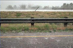
August 18 looked like a fairly marginal day for supercells. However, a deviant moving storm developed south of Limon, CO and moved southwest enhancing its shear to the fullest extent. This storm produced COPIOUS amounts of hail over southeast Lincoln county that destroyed every crop, tree and building in its path. Hail fell for about 40 minutes and ranged in size from quarter to golfball.
July 20th, 2006 Goshen County, WY Supercell
July 20 promised to be a day with decent shear, instability and moisture, with a strong wave moving southeast out of Montana late in the day. Morning cloudiness cast a doubt on anything decent happening, but by noon, the mid level clouds eroded and good surface heating commenced. It didn’t take long for storms to fire up, and this storm became the storm of the day, producing tennisball sized hail, at least two funnels and intense lightning. It developed along I-25 south of Chugwater, WY and dissipated along the WY/NE border. It was one of the prettier storms of 2006!
July 17th, 2006 Eastern Colorado Severe Weather
July 17 featured a persistent boundary across eastern Adams, Arapahoe and Elbert counties in Colorado with deepening moisture on easterly flow. Shear was marginal, but with the boundary in place and strong instability, storms developed along the boundary and two of them spun pretty strongly, causing the NWS to issue tornado warnings on them. We caught them as the intensified and produced a couple of funnels, although we never could confirm touchdown. The one pictured above appeared to be anticyclonic as it formed on the south side (looking west) of the clear slot of this rotating storm.
July 13th, 2006 Greeley, Nebraska Supercell
July 13th had a great set up potential for Nebraska. Strong shear, a nice boundary and mid 70s dewpoints would all come together and produce a nice supercell in north central Nebraska. I came from Grand Island north to catch it. SPC mesoanalysis page showed the best of the best conditions feeding into that storm! (I just couldn’t go for the elevated trashy crap heading towards OMA) I sat just south of Greeley to watch it before heading west towards Ord. I was looking west at it, and it had a nice soda can/bell shape to it. Nice structure, tried to produce, but just couldn’t. Typical 2006. The core had solid 1.5″ to 2″ diameter hail from it. I also encountered winds gusting to 82 MPH (measured!) not far from Greeley when it gusted out.
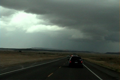
June 25th, 2006 Northeast New Mexico Surprise Tornado
The first day of my North Land Lecture Tour resulted in a “south land” weak tornado! What a surprise! We headed south from Denver and crossed the Raton Mesa, only to see what looked like supercell structure near Mt Capulin volcano. East we blasted and caught up to this cell as it produced a distant weak tornado!! What a surprise!! Later on, a weak LP type supercell formed near Springer and had decent structure for awhile.
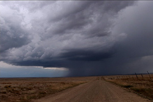
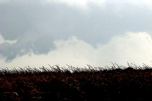
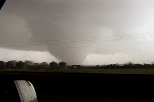
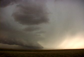
June 23rd, 2006 Northwest Nebraska Tornadic Supercell
June 23rd was a day that had promise for high based storms in western Nebraska. It lived up to its potential and more! We caught the first supercell of the day that formed northwest of Scottsbluff and was a nice LP storm. The second LP storm formed northeast of Torrington and had very nice structure. And finally the storm of the day formed west of the Black Hills in northeast Wyoming and tracked southeast into northwest Nebraska. This storm had beautiful HP supercell structure and produced a couple of short lived tornadoes, one of which is shown below.