Tag Archives | 2002

August 28th, 2002 Lamar, Colorado Tornadic Supercell

Left Denver at noon headed for southeast Colorado where more sunshine and a boundary were present. By the time I reached Limon, I already saw thunderstorms explode to my south. So I blasted quickly south on 287 and by the time I got to Eads, the first TOR was issued. All I could see was this electrified wall of white in front of me and of course knew what it meant. I hit the core at 2:55 PM north of Wiley and was greeted with tennis ball sized hail on my already cracked windshield. So I pushed through it. South of it, just north of Wiley, I saw a large slowly rotating wall cloud, perfectly bowl shaped. At about 3:15 PM I could see a rotating dust bowl under it. Not a great dust bowl but I would call it a tornado. It persisted for about 5 minutes.

Then south I went cutting through dirt roads (dry) to get back southeast of the updraft. The updraft was a highly striated updraft at least 10 miles across with a VERY LARGE laminar beaver tail streaming in from the southeast. I made it just southwest of Lamar when I noticed an occlusion taking place and strong wet RFD winds wrapping around the occluded meso. Soon a white cone tornado formed. The debris cloud was entirely of dark brown dirt. It stayed on the ground for about 6 minutes before it dissipated. Then I made it to 287 and zig zigged east/southeast to stay in front of the meso and be able to look down the notch of this now HP storm. A landspout formed to my west, about 10 miles northwest of Twin Buttes and persisted for 17 minutes. The storm continued to march south/southeast, slowly and became an electrified monster!! I called off the dogs and went back through the core to get to 287 again and headed north to get back home.

That is when all things came to a stand still. I passed a bridge where water was flowing up to the bottom and a person’s house was flooded about 4 ft deep. I figured I could make it back to Lamar (only 7 miles), but the road was closed due to flash flooding in front of me. I sat there for 3 hours blocked in front and back by flooding. Hail was piled up at least 6″ deep across the fields.

August 24th, 2002 Paoli, Colorado Mothership Supercell

August 24 kept me in the Colorado and Nebraska area. An old outflow boundary would be the focal point for severe weather this day. I headed out to Julesburg and played an elevates supercell moving across southwest Nebraska. This storm did produce large hail, but I did not see a tornado, even though a couple were reported with it. I ended up playing a very scenic supercell coming out of Nebraska into Sedgwick county, Colorado. This storm was rapidly rotating and exhibited beautiful structure. It also produced golf ball sized hail covering the highway.

August 8th, 2002 Reva, South Dakota Tornadic Supercell

My last day out would be one of my favorite on this trip. A boundary was present from overnight convection across northern South Dakota into North Dakota. I decided to play where the winds were backed and the approaching short wave would intersect the boundary. By 2 PM a supercell rapidly developed along this boundary near Buffalo, South Dakota. This storm became a monster supercell and produced copious amounts of baseball sized hail and a small tornado just northwest of Reva, South Dakota. Then the first cell died as it crossed the boundary into North Dakota, and a second very nice HP supercell developed back over Buffalo.

August 6th, 2002 Lewistown, MT Awesome LP Supercell

August 6th was a simple an fun chase day. For the second day in a row significant severe weather was a sure bet. I spent the night in Lewistown, MT and didn’t have to leave. By lat afternoon an HP supercell developed just east of town. This storm produced high winds and large hail. Another, by far prettier supercell developed just west of the first. It became my favorite LP supercell of the year as it went on to survive for 6 hours and produce softball sized hail.

June 23rd, 2002 Brown County, SD Cyclic Tornadic Supercell

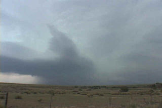
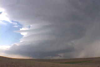
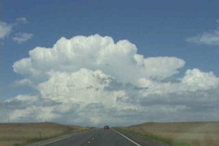
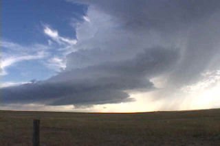
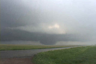
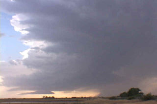
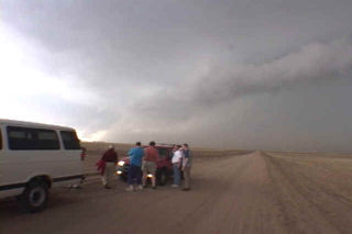
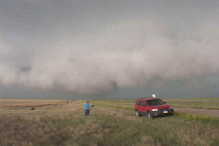
I left Denver with my tour group headed for my target of Aberdeen at 6 AM. Nearly 850 miles later, we arrived. A nice warm front boundary/dryline intersection was very evident on NEXRAD from ABR. We sat there and waited, for a whole 45 minutes for storms to form. Towers went up on the triple point, but could not get into the deep moisture. The west side of the dryline temp and dews were 97/54 with a 240 wind at 20. East of the triple point temp and dews were 91/72 with a 170 wind at 15. North of the warm front temp and dews were 81/77 with a 80 wind at 15. Perfect set up!!! Not to mentions 50 kt 500 mb winds and SBCAPE of 5,500 j/kg. Around 6:30 PM an area of congestus managed to sustain itself south of Forbes, ND, and north of Leola, SD. A storm rapidly developed here. We blasted through the core to be greeted by a long beaver tail being inhaled by the updraft. I have NEVER seen such a beaver tail moving westward at such a rapid motion into the updraft before. It was incredible. The updraft had a low pregnant base with a gorgeous vault visible extending to the northeast. The storm was moving east. At 7:18 PM CDT, a dirt swirl appeared under a rapidly rotating base. By 7:20 PM a rather large tornado developed and crossed county road 23. This tornado had VIOLENT motion at the base and became a large dusty cone. As it moved east the meso took on a large perfectly round barrel shape as the tornado, now a wedge, continued east. At 7:50 PM it dissipated completely as an occlusion was clearly in progress.

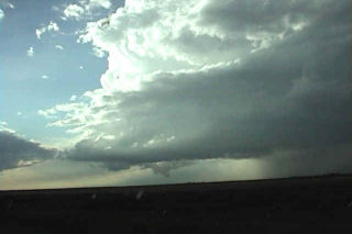
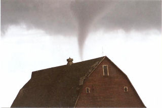
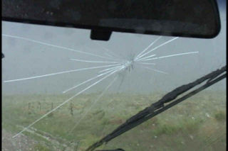
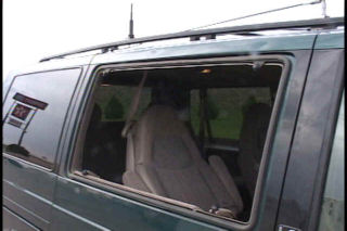
At 7:50 PM, the second tornado developed about 2 miles northeast of the first and just northeast of my position. It was a beautiful white elephant trunk with inky black debris cloud. It quickly widened into a large stovepipe with a satellite tornado on its north side. A second satellite tornado developed to its west and roped quickly. We decided to get east of the tornado on highway 10, and to our surprise, it started moved southeast. We drove to the south of it as debris was falling on the vehicle. The tornado was only 200 yards to our north as the outer edges of the debris cloud engulfed our vehicle as we sped east of it. Too close a call for me!!! We stopped a half mile east and shot more video of this now large stovepipe, turning into a wedge. The sun lit the background orange as the black wedge bore down on our position. We headed east on a dirt road stopping to shoot continuous video, only to be chased back in our vehicle to escape. As we drove past a farmhouse a husband and wife were outside watching and waving us to stop and seek shelter.

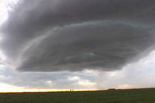
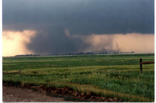
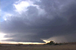
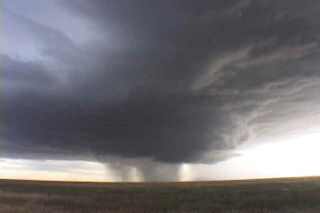
The tornado, now visions of Pampa 95, bore down on their house. I only hope they made it to the basement in time as the violently rotating tornado headed directly for their house. We continued east and finally stopped for video to watch the tornado dissipate at 8:18 PM. We ran into Gene Rhoden and he quickly pointed out another rapidly developing tornado to the southeast of the previous one, on the ground at 8:23 PM. We dropped south 2 miles and headed east again as a beautiful grey elephant trunk developed with large debris cloud. Another satellite tornado developed on its southern side and lasted for 3 minutes before being swallowed by the now large wedge. This tornado dissipated at 8:36 PM. Finally a large stovepipe developed at 8:36 after another occlusion and was the most photogenic of all. The sun had come out under the barrel, striated updraft and this tornado was being blocked by the setting sun. What an awesome sight!!!!!!! It stayed in place until 8:54 when it finally roped out. All in all, 5 significant tornadoes, 3 satellite tornadoes and a landspout. This storm was one of the prettiest warm front cyclic supercells I have ever seen.

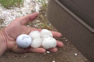
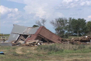
We went back to the NWS office in Aberdeen to share our video with them and to look at the damage survey they did. Clearly the last tornado was F4 or low end F5 (F4 officially) and several other tornadoes were F2 and F3. Fortunately the town of Barnard was spared as there would have undoubtedly been total destruction there. I received some incredible photos from Mr. Gene Olson of Barnard, South Dakota. They are very worth checking out. Click on this link to see them. They are awesome. OLSON TORNADO PHOTOS.

June 23rd, 2002 South Dakota Tornado Photos of Gene Olson

The photos contained on this page belong to Gene and Carrie Olson of the Barnard, South Dakota area. They are used with their gracious permission. These photos were taken on June 23rd during the Brown county South Dakota cyclic tornadic supercell. The large tornado heading for their farmstead fortunately dissipated just prior to a collision course with their farmstead. In one up close photo (4th from the bottom) you can even see yours truly in a white van heading away from the ever encroaching tornado. Another tornado, that went on to become an F4, is seen developing just east of their farmstead in the last 3 photos. 

June 15th, 2002 Eastern Colorado Monster Hailstorm

Being between tours, I decided to chase on my own this date. I headed for far eastern Colorado to play an outflow boundary that had raced westward into Colorado from western Kansas. Several significant supercells developed in east central Colorado, with the most intense being an anti-cyclonic storm in Cheyenne county. This storm had a streaming beaver tail from the east, the updraft on the northeast side, huge hail core on the west/southwest side and was an awesome stack of plates. It intensified rapidly as I decided to core punch to see what she had in her. It was much more than I bargained for as I was pelted with considerable amounts of golf ball to baseball sized hail. There wasn’t a straight piece of metal on my van afterwards!!!

June 4th, 2002 Lubbock, TX INCREDIBLE Supercell

All I can say about this storm is OH MY GOODNESS!!!!

Early convection almost destroyed this day. A line of severe thunderstorms developed (totally outflow dominant!!) and produced awful outflow. This outflow was very slow to modify. A triple point was situated southwest of Lubbock and our only hope was for new convection to develop later in the afternoon near the triple point, once the air had a time to modify. A tornado watch was also in effect. Due to the slow modification of the outflow boundary air, this storm could not produce a tornado. If only it had been a few degrees warmer and moister!!!!! Nonetheless, this was probably the prettiest supercell of the year. It started out as a skinny LP storm and morphed into a gorgeous classic that produced 80 mph wind and baseball sized hail.

June 3rd, 2002 Lincoln County, CO Hailstorm

This was almost the destruction of the vans. Unfortunately it did happen later near Kit Carson, Colorado between tours. On June 3, a high based supercell developed over the Palmer Divide before noon and took its slow sweet time getting well organized. By the time it approached the Limon, Colorado area, it was a full blown hailstorm. This storm produced 90 mph winds and 4″ diameter hail. We were pelted a couple times with baseball sized hail. We knew the tornado threat was virtually zero as this storm was totally outflow dominant.

May 27th, 2002 Crosbyton, Texas Supercell

It just doesn’t get much closer than this storm did without producing a tornado!!!! That was the saying after this day was done. An LP storm formed east of Lubbock and produced a couple landspout type tornadoes. But as it moved off the Caprock, it died, as many do. A second storm formed on the outflow from the first storm. I thought it was going to get the job done and produce a large tornado. However, it ingested too much cool outflow air from the first storm and became outflow dominant. Very disappointing!!! Although the structure on this storm was well worth the price of admission.