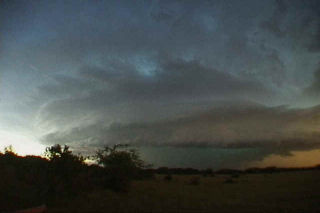
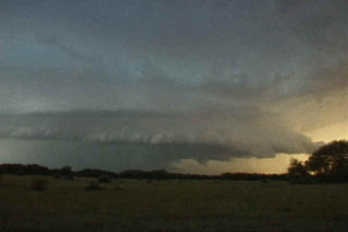
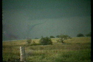
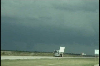
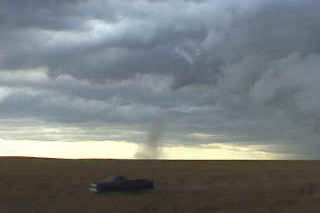
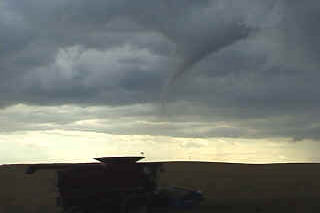
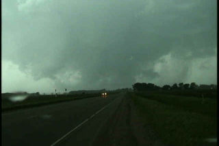
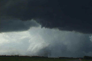
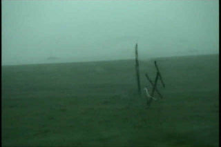
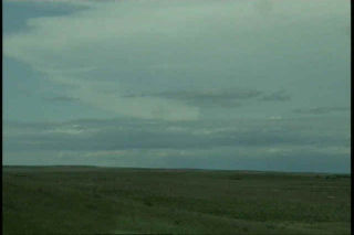
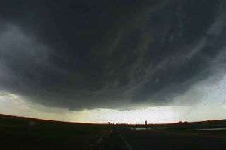
I had no idea was the results of Sept 22 chase would be, but I certainly did not expect what I got. My son and I left early morning for our target of York, Nebraska. We arrived by mid afternoon to a cirrus shield and stratus left over from morning convection. However, an outflow boundary was in place from near Grand Island southeast towards Concordia, Kansas. We sat and sat with nothing happening. Then finally around 6 PM (6pm magic !!), things started to change. Towers were exploding not far from Clay Center and soon our first storm developed. It did not look that great, but was only a harbinger of things to come. Another cell went up and produced several small funnels. Then a larger funnel formed and eventually touched down near Saronville, Nebraska. It later dissipated only to be replaced by another, yet larger tornado at dark. The second tornado was eventually rated F3. We found a prominent damage path and a couple of farmsteads destroyed. This storm had the classic mothership appearance and was one of the prettiest supercells of the year.
August 23rd, 2001 Russell/Lincoln Counties, KS Supercells & Tornadoes
What a pleasant surprise this chase was!! An impressive vort max and stacked low were over northeast Colorado moving into western Kansas. By 10 am, storms were firing to the east of the vort max. I decided to blast out of Denver to get in front of this vort center and hopefully find a rotating storm. I found much more than that!!! First, a tornado occurred in Gove county, Kansas near the Castle R o ck state park. Nice small landspout. Next a rather large supercell exploded in the unstable air over Russell county, Kansas as I blasted east on I-70. Another landspout occurred near I-70 in Ellis county, Kansas. As I arrived on the now confirmed tornadic supercell, I saw a huge hail core that contained baseball sized hail. I headed east to get in front of it and southeast of the updraft. As I did a rather large stovepipe tornado formed under the rotating meso. Secondly, another smaller white tornado formed on the east side of the meso as the storm entered Lincoln county, Kansas near the town of Sylvan Grove. The storm soon went HP as I headed east towards Salina to get in front of it and watch the shelf cloud mature. But not before I was pummeled with golf ball sized hail and 70 mph winds. It was a beautiful sight!!! Please enjoy the video stills below.
August 1st, 2001 Lincoln County, CO Supercell & Tornado
Interesting set up this day. Another boundary lay east of Denver with a nice winds shift and pseudo-dryline running from Ft Morgan to Limon. Air to the east was very moist and unstable. By mid afternoon isolated storms developed on the boundary. They started fairly high based as shown in the first couple pics below. As early evening arrived, the bases lowered as temps dropped and the dews rose. A nice supercell developed west of Limon and tracked north, then east across Lincoln county. This storm had awesome structure with a nice vault, shelf, tons of CG and even a small landspout tornado. By dark the storm weakened as the atmosphere stabilized, but not before leaving an incredible image etched in my mind.
July 26th, 2001 Arapahoe County, CO Tornado
July 26 was a day with good possibilities for eastern Colorado. Decent shortwave energy was present, along with good instability and the DCVZ boundary setting up in eastern Arapahoe and Adams counties. I headed out the door shortly after lunch with a target to get under developing thunderstorms near the Byers area. Upon arrival just east of Byers, a nice cell had developed and was racing northeast rapidly away from me. Another cell was developing southwest of town, and this cell was the one I targeted. By 2 PM, a nice bell shaped, candy cane striated mesocyclone developed on the eastern side of the storm. Soon, rapid rotation was evident. At 2:28 Pm the tornado touched down and stayed on the ground for over 10 minutes. Overall a very nice storm and I fortunately got the results I had hoped for.
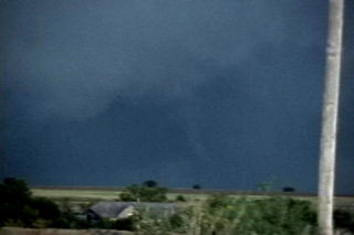
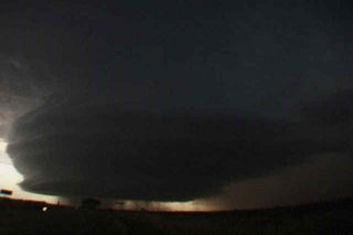
July 22nd, 2001 Faith, SD Tornadic Supercell
After chasing in northern plains with Rocky Rascovich (great chasing with you!!), my friend Dave Brown and I left eastern South Dakota headed west to a supercell coming out of Montana. As we approached the Mobridge, South Dakota area, we noticed a very long, fairly sharp anvil streaming to our northwest. The closer we got, the more I realized that this storm was something special. When we were about 20 miles east of Faith, we noticed a highly striated updraft that was very electrified. The lighting would light up the vault and reveal an awesome liberty bell shaped updraft that was obviously rotating. This storm had not one, but three inflow bands!!!!!! The updraft was moving just south of southeast, while the anvil was streaming almost due northward. As we got closer, about 20 miles from the updraft, we noticed a well formed wall cloud. At about 8 PM, a rather large cone tornado formed, with a nice tail cloud extending to the east. It stayed on the ground for 5 minutes before rapidly dissipating. As the updraft pushed to our east, we stayed behind it and watched an awesome CG show!!!
June 11th, 2001 Benson, MN Tornadoes
This day was one of my all time favorites. An incredible set up with a warm front lifting northward through southern Minnesota, an approaching short wave and developing cyclone in northeast South Dakota set the stage for explosive thunderstorm development. The day started in Granite Falls, MN under cloudy skies with elevated convection. The morning convection soon cleared and left us with southeast winds at 35 mph with a temp of 90 and a dewpoint of 72!!! WOW!!! All things were pointing to the area northeast of Watertown, SD as the hot spot. Winds were backed wonderfully, but the atmosphere was strongly capped. Shortly after 2 PM, the first surface based tower exploded after several hours of excellent convergence, into a strong supercell that within an hour, produced the Benson tornadoes. This supercell was on the wet side of classic, but morphed into an intense HP storm. By the time it approached the twin cities, we left it for the night. Please check out the photos below, as some are breathtaking!!!
June 9th, 2001 Bismarck, ND Supercell & Tornado?
June 9, 2001 took us to North Dakota. Never again will I underestimate the importance of a boundary in tornado genesis. A weak bubble high formed over South Dakota after a morning MCS moved through, scouring out all moisture. However, north of the warm front in western North Dakota moisture was pooling with dewpoints in the 60s. So north we headed. There was 50 kts at 500 mb, great veering profile, high CAPE, and an approaching short wave. On the way northward through South Dakota, dewpoints bounced from the upper 40s through the 60s, but by the time we hit I-94 they increased to 66F. A couple of severe storms were ongoing, with one storm potentially tornadic. Other storms rapidly formed along the boundary, which was also collocated with I-94. Within 30 minutes upon arrival, a supercell exploded just to out east, so we raced after it, and what a show it gave us. Rapid cascading from the RFD was visible, huge hail soon followed, and finally as we got in front of it a possible tornado crossed in front of us causing significant damage.
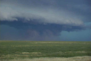
May 29th, 2001 Childress, TX Tornadic Supercell
May 29 was a day with tremendous tornadic potential in the Texas panhandle. Incredible shear, instability, CAPE and a boundary existed. SPC issued a PDS tornado watch box for the panhandle by early afternoon. We sat in Amarillo till the initial storm developed near Tulia. This storm took a long time to get its act together and even split 4 times. Typical for a high CAPE/high shear environment. Finally the supercell got going near Turkey, Texas and lost some of its outflow dominant appearance. A couple of possible rain wrapped tornadoes were seen as rapid cascading rain curtains were less than a mile away from us. I could even see condensation fingers rising and wrapping into the rain curtains. By early evening, this storm became my all time favorite supercell. It looked like an upside down wedding cake with the entire updraft rotating. About dark a rather large tornado developed near the town of Quanah, Texas and caused damage. The irony of it all is that just to our north a tornadic supercell produced several large tornadoes near the town of White Deer, Texas!
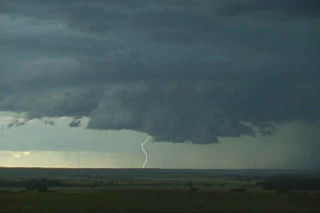
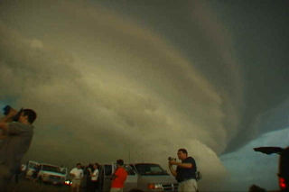
May 27th, 2001 Barber County, KS Weak Tornado & Supercell
May 27 was a potentially violent day for the plains. A frontal boundary was draped across southern Kansas, and elevated severe storms developed north of this boundary. We decided to wait for any surface based convection to develop south of the front, and finally we were treated to a very violent, hail producing supercell that eventually went upscale into an incredible MCS that blasted Oklahoma that night. Pics of the supercell, weak tornado near Sitka, and incredible “outer space” shelf cloud are shown below.
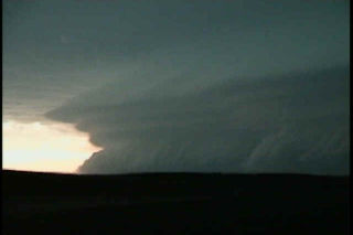
May 24th, 2001 Rock Springs, Texas
Oh what a beautiful HP supercell near Rocksprings, Texas this day. An old boundary was in place, and with decent shear and very high CAPE values, severe storms were imminent. Although fairly high LCLs were in place, a tornado watch was posted for south central Texas. This storm formed west of Rock Springs about an hour before dark and was probably in my top 5 of photogenic storms ever.