September 22st, 2001 Clay County, NE Tornadic Supercell
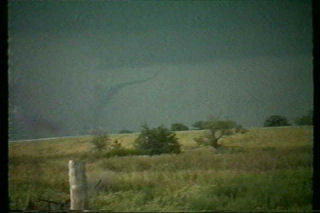
I had no idea was the results of Sept 22 chase would be, but I certainly did not expect what I got. My son and I left early morning for our target of York, Nebraska. We arrived by mid afternoon to a cirrus shield and stratus left over from morning convection. However, an outflow boundary was in place from near Grand Island southeast towards Concordia, Kansas. We sat and sat with nothing happening. Then finally around 6 PM (6pm magic !!), things started to change. Towers were exploding not far from Clay Center and soon our first storm developed. It did not look that great, but was only a harbinger of things to come. Another cell went up and produced several small funnels. Then a larger funnel formed and eventually touched down near Saronville, Nebraska. It later dissipated only to be replaced by another, yet larger tornado at dark. The second tornado was eventually rated F3. We found a prominent damage path and a couple of farmsteads destroyed. This storm had the classic mothership appearance and was one of the prettiest supercells of the year.


No comments yet.