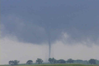
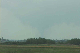
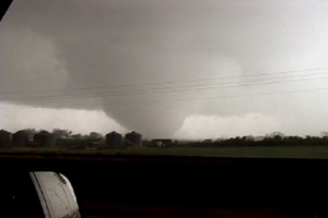
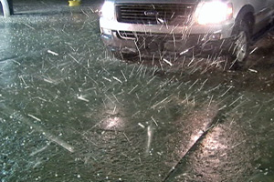
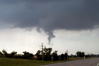
June 6th had all the ingredients for significant severe storms, including tornadoes. Good shear, a strong wave, good instability and respectable moisture would set the stage for supercell storms. SPC issued a MODERATE RISK and associated tornado watch box for western South Dakota. By 1 PM we had arrived in Wall and stopped for lunch. A couple of small towers were going up south of us. After 45 minutes of our lunch break, a supercell rapidly developed south of town. As we gathered the clients and headed out, it didn’t take long for a tornado to form. This tornado, although not terribly strong, stayed on the ground for 25 minutes. We could never get any closer than 15 miles from it. Later, the storm turned into a monster HP supercell before lining out.
August 24th, 2006 South Dakota Tornado Outbreak
What an event!! After watching model run after model run I couldn’t resist the 1700 mile round trip to eastern South Dakota from Denver to chase this one!!! I arrived in Sioux Falls, SD around 3 PM. I couldn’t decide whether to sit tight, head to southern Minnesota or head west towards the advancing front. Each situation had its positives and negatives. After much analysis and some very quick driving, I decided to head west towards the front, which now was firing a string of supercells along it. I targeted the southern supercell coming across the Missouri river north of Pierre. I caught up with it east of Oneida and what a sight it was!!! It took about 10 minutes for it to drop its first of 7 tornadoes that I saw. The structure was second to none as this beautiful striated updraft produced one tornado after another. The largest and strongest tornado developed southwest of Wessington and tracked southeast near Wolsey to southwest of Huron before dissipating. It stayed on the ground over 40 minutes and resembled the Manchester, SD tornado from June 24, 2003 (which I saw from the south side). Finally, the storm produced one last tornado southeast of Huron as it weakened moving towards I-29.
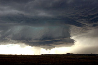
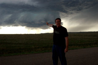
June 13th, 2006 South Dakota Badlands Supercell
I wasn’t expecting much this day, but couldn’t resist a play off the Black Hills of South Dakota. By mid afternoon a VERY high based supercell formed near Hot Springs. As it moved off the hills, it weakened and almost died. Then, not far from the western edge of the Pine Ridge Reservation, it intensified and became a wonderful high based hailer. The structure was as textbook of an LP as one could get. The most beautiful part was right at sunset as the sun lit the updraft and anvil, complete with reflected convection in the anvil.
May 28, 2006 South Dakota Supercells
May 28 took us to northwest Nebraska and southwest South Dakota to play an advancing trough out of the Rockies. It became apparent again that moisture would be the issue as has been the case for most of the season. Storms formed along a boundary in western Nebraska and raced into South Dakota. Two supercells formed that we chased, both producing high winds and hail, but little else. We encountered intense winds with a bow echo east of Rapid City late in the evening that was quite spectacular.
June 26th, 2005 Dakotas Tornadic Supercells
Being the first day of the tour, we drove QUICKLY to South Dakota where we caught a decent supercell. Conditions looked good with high instability, decent shear and an outlfow boundary from previous night convection to focus intense convection on. It produced a couple of weak tornadoes before lining out. We then blew it off and drove towards the Bismarck, ND area where we caught a nice sculpted supercell that produced a couple of weak circulations.
June 8th, 2005 Oskaloosa, Kansas Tornadic Supercell
I must admit, this day caught me by surprise. We started in eastern South Dakota. After morning analysis and looking at model data, it appeared to be a respectable chance for large supercells in eastern Kansas with extreme instability and decent shear. As we arrived in Jefferson county, Kansas a supercell exploded from a small cumulus tower. Within 20 minutes the top was at 60,000 feet. Within another 30 minutes a tornado formed. This tornado narrowly missed the town of Oskaloosa.
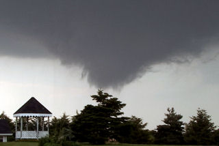
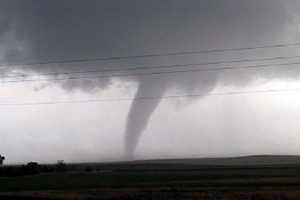
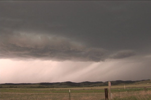
June 7th, 2005 South Dakota Badlands Supercell & Tornado
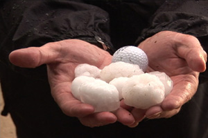
June 7 looked like a big tornado day in South Dakota. By the end of the day, it would be disappointing from the aspect, but the supercell I caught that day was special. The structure was phenomenal!!! This storm formed on the western end of the Badlands, and slowly tracked east/northeast towards I-90. This storm produced at least 1 tornado, and hail to 3″ in diameter. The prettiest part about this supercell was the structure.
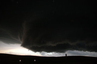
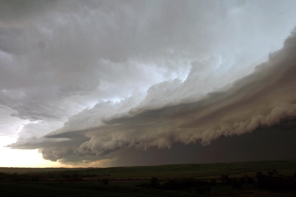
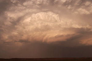
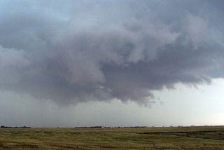
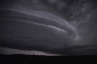
May 20th, 2005 Harding County, South Dakota Supercell
What a remarkable day this turned out to be. We were in O’Neill, NE overnight and decided to blast towards northwest South Dakota for what we hoped would be a nice high based supercell. And what a supercell it was! We spent some leisure time in Belle Fourche, SD waiting for things to happen. We spotted a tower to our north and blasted to the Buffalo area. When we arrived we witnessed a convective explosion!!! A gorgeous rock hard updraft formed and produced one of the most scenic supercells I have seen this year. This storm produced hail golfball sized and was tornado warned for two hours. We were witness to several funnels, but could never confirm any touchdown. Several times, the clear slot produced a nice wall cloud, only to be shrouded by rain and hail.
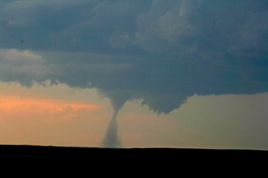
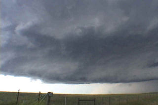
July 8th, 2003 Bell Forsche, SD Supercell
Limited moisture would destroy the possibility of a significant tornado on this day. Wonderful wind shear would be enough to get a couple intense supercells developing. One such storm developed in southeast MT and moved into western South Dakota. This supercell did everything it could to produce a tornado, but could not. However it did exhibit impressive structure. As night fell in South Dakota, this storm became an electrified monster.
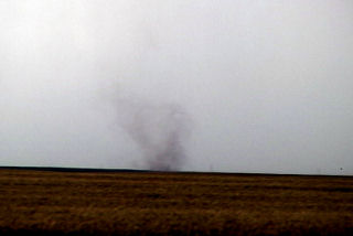
June 24th, 2003 South Dakota Tornadofest
Some days you never forget. This day was to be one of those days. I spent the night in O’Neill with my tour and my fiancé Caryn who had yet to see a tornado. This was to quickly change. Morning analysis showed a well defined boundary along the NE/SD border extending east/west. This boundary slowly drifted northward into South Dakota by early afternoon, as did we. Cells started developing west of me in the hot air, but we waited patiently near Pickstown, SD. By 3 PM, it was evident we needed to go north to near I-90 and the Mitchell area. As we drove north, a supercell rapidly developed just west of Mitchell. By the time we could get the base into view, a huge block wall cloud was visible. Soon, a large cone tornado formed west of Mitchell, south of I-90. We approached the tornado to our north, but were a good 10 miles from it as it roped out, while another weaker tornado formed after the occlusion to the east. By the time we reached updraft base, the show was over. But we did manage to catch a couple decent views of both tornadoes.
Next, I noticed an explosive updraft northwest of town. We raced northwest towards the town of Woonsocket and as we approached a truncated cone tornado formed. This tornado morphed into a large stovepipe, then elephant trunk, then stovepipe again as we watched from 1.5 miles east of it. A GORGEOUS tornado to say the least. After 12 minutes, it dissipated. The occluded updraft died, as a new meso formed to our northeast. However, now the road options were pathetic with only dirt and gravel roads to use to keep up with the storm. As we zigzagged across the countryside northeast of Woonsocket, another supercell was developing farther to our east. It quickly dropped twin tornadoes about 8 miles east of us. We decided to abandon our efforts on our shriveling storm and go after this intensifying tornadic supercell south of Iroquois, SD. As we maneuvered muddy dirt roads, another tornado formed under the new storm. This nice rope tornado was about 5 miles to our east. As we got closer, now about 6 miles south of Iroquois, a multivortex tornado formed along with a small satellite tornado. What a sight!!!!!!!
I decided to get the tour closer, so we raced up to Iroquois, then east of highway 12 toward Manchester and DeSmet. I knew we would have to punch the hook of the storm and warned everyone what we could find as we punched it. Sure enough, just west of Manchester a VERY LARGE tornado had just crossed the road about 300 yards in front of us. This tornado was very violent. As it ripped the town of Manchester apart, we sat in awe as the tornado dropped tons of debris all over the countryside. It moved north of Manchester and continued to be a violent tornado (rated F4) as it went through a long rope stage. Finally it roped out as we decided to head towards DeSmet. Another multivortex tornado quickly formed after yet another occlusion and stayed on the ground for 4 minutes. Finally, northwest of DeSmet the last and very photogenic tornado occurred and last nearly 15 minutes!!! What a day!!!!!