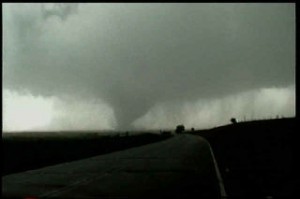
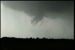
My encounter with a gorgeous F3 tornado and associated supercell near Almena, Kansas on June 3, 1999 was my favorite chase of the year. The setup was a simple forecast to nail. A dryline was evident based on surface obs in western Kansas. An east/west outflow boundary was in place from previous night’s convection. By noon the dryline was surging east as is typical with the dryline. About 3 PM a line of towering cu were seen on visible satellite and from my position. A dryline bulge formed across west central Kansas, so I decided to get into position to the northeast of the dryline bulge where it intersected the outflow boundary, and the results are shown below. A rather isolated supercell formed and produced a very photogenic slow moving F3 tornado!!!!! Beautiful storm. These pics first show the development of the supercell. Then there are a series of 12 photos that show the development, maturity and dissipation of the 1/4 mile tornado.