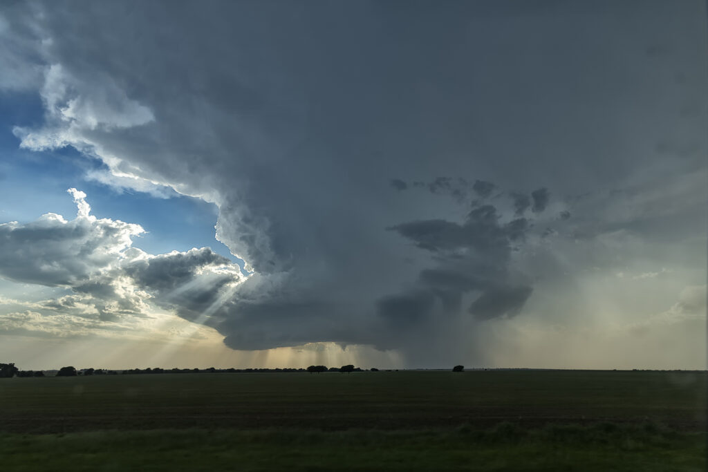
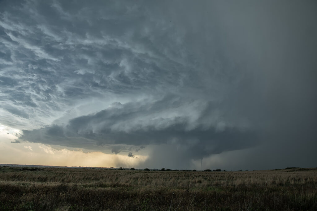
May 9th looked like a day where things just weren’t in sync. Good shear and lift were in place, but poor moisture with moderate CAPE were also in play. We targeted southwest Oklahoma where there was a bit higher moisture, however it was very thin. Storms blew up along a boundary near I-40 and became severe. They were fairly high based, but with good shear and steep lapse rates, they rained down hail to baseball size. We blasted north to catch the tail end storm as it moved into western Oklahoma. It hit the theta-e axis and rapidly strengthened. As it moved southeast towards us, structure steadily improved. We stayed with it till after sunset as it started producing copious amounts of CGs. Finally, it weakened around 10pm so we left and made it to the hotel before midnight. A great day with arguably the best structure of this young 2026 season! Enjoy the pics!!!
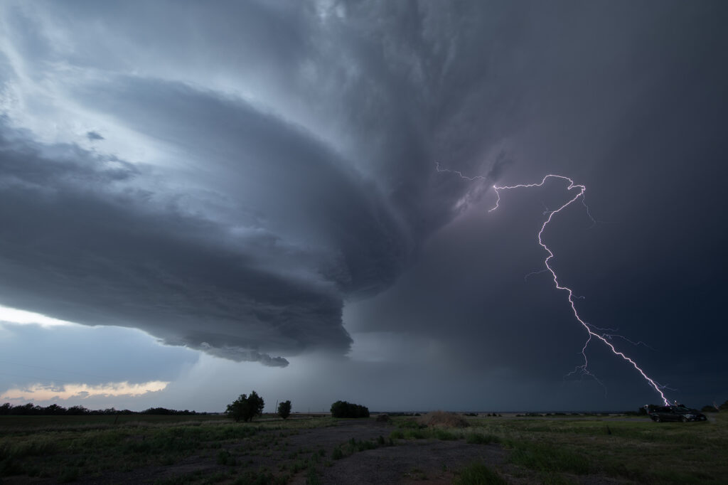
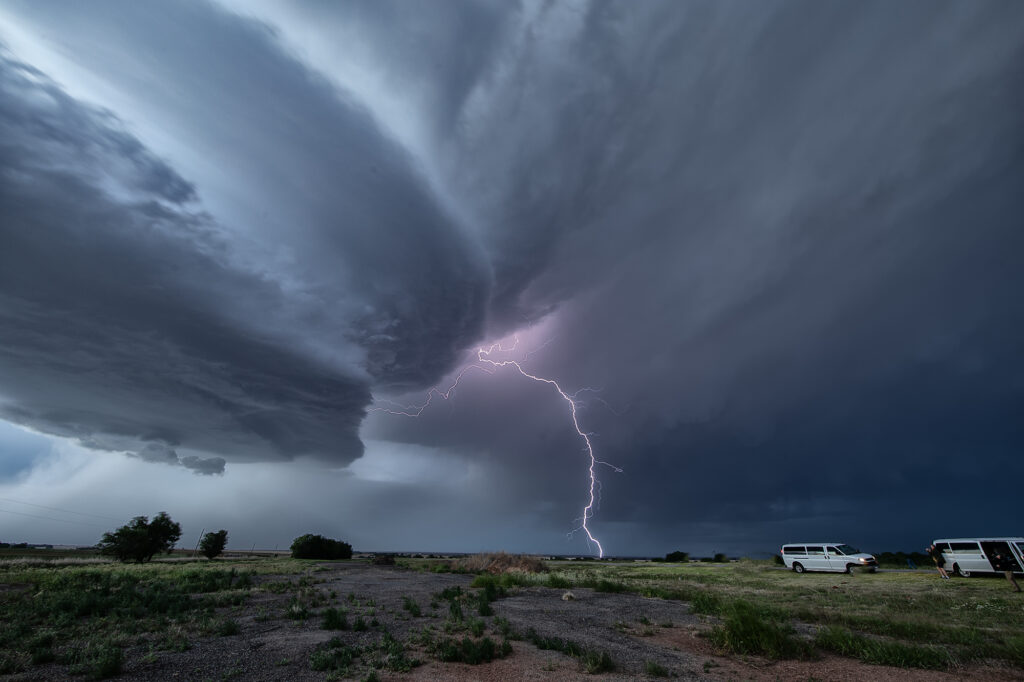
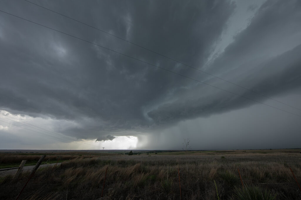
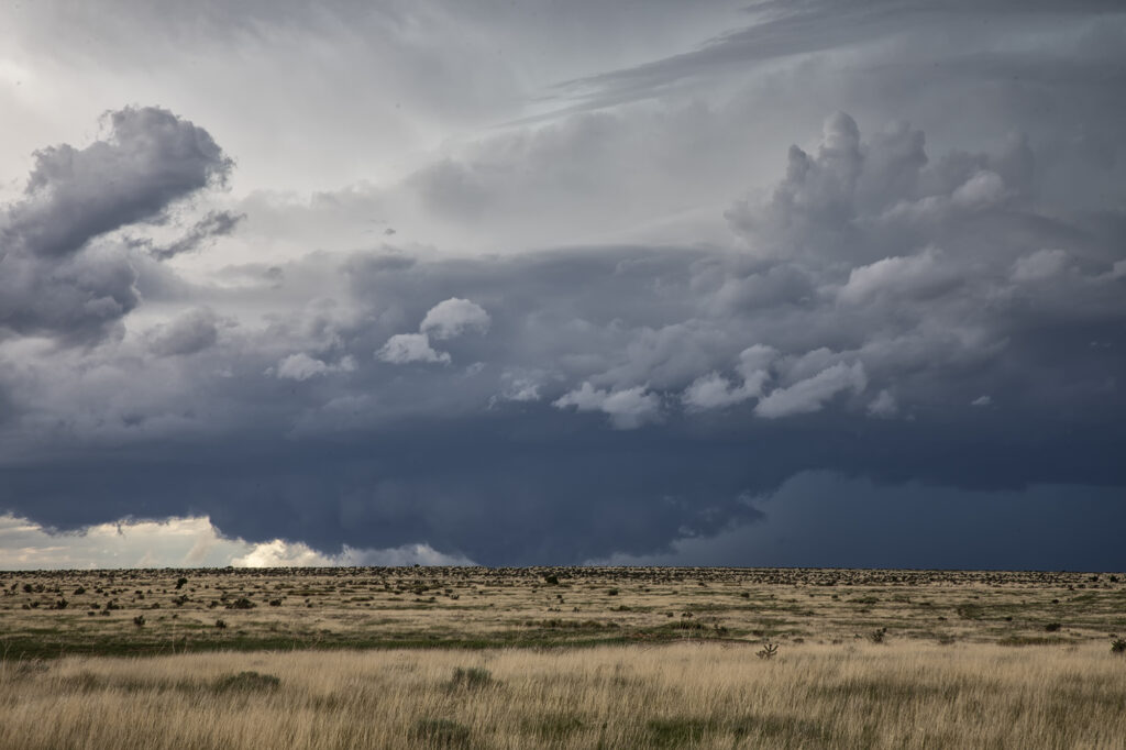
May 8, 2026 Chattanooga, OK Tornado Warned Supercell
Good shear, but limited moisture would be the problem this day. Storms formed along a cold front in central Oklahoma by mid afternoon, but were high based. We were watching a cluster of towers west of Lawton and hoped something would form from them. Later in the afternoon, they did just that. A supercell emerged and produced baseball sized hail. Early evening it became tornado warned. It produced a couple of funnels but was moving into capped air and weakened. The setting sun made for a cool image as the updraft evaporated.
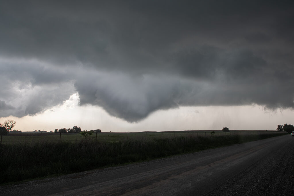
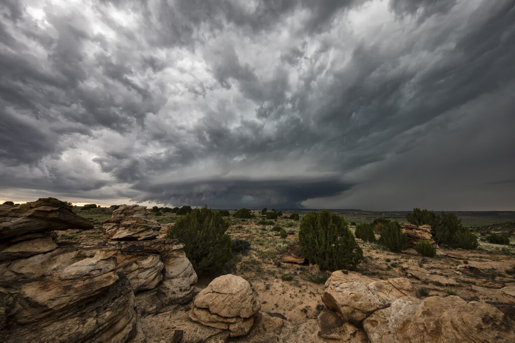
April 26, 2026 Osage County, OK Tornadic Supercell
April 26, 2026 took us to Osage county, Oklahoma to chase a tornadic supercell from Foraker to Herd. Strong shear, a dryline and extreme instability would set the stage for supercells. One such storm formed near Blackwell and intensified as it moved east. It became tornado warned as it moved east towards Foraker. Due to poor, muddy roads, we had to drop south to highway 60 and east to Pawhuska, then north to get in front of it. During this 20 minute process, of course, fate would have it that it produced a tornado! However, it was on the ground for less than a minute. As the supercell approached us a broad, rotating wall cloud was evident, and multiple funnels formed over the next 30 minutes. This storm had great structure and intense cloud to ground (cg) lightning! As it approached our location, a large bowl formed under it and soon a cone funnel descended to the ground. It persisted for a few minutes. We stayed with the storm in the dark as it moved east and eventually dissipated near Bartlesville. Fun day, frustrating at times as is often the case in Osage county, but good end results! Enjoy the pics!
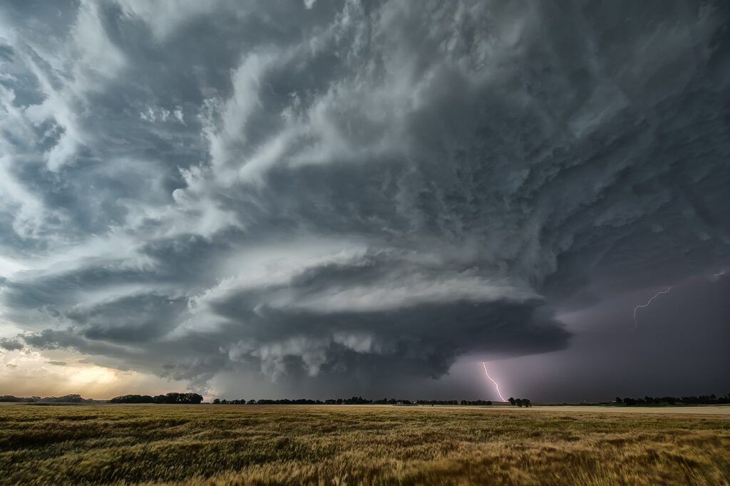
April 25, 2026 Southeast Oklahoma Tornadic Supercell
Day 1 of the Close Encounters tour kept us very close to Oklahoma City. A warm front/dryline triple point was just south of town. Models show extreme instability developing during the afternoon, with isolated supercells forming. Mid afternoon we drifted to Sulfur as storms formed close by. As they moved east the weakened moving north of the warm front. Eventually one storm anchored on the boundary and started spinning. It produced and bog cone funnel that just could stay consolidated, and fell apart after a few minutes. Due to many storm interactions, we dropped south to the tail in cell near Mill Creek. As we arrived a tornado formed. We saw the debris cloud from a rock plant and were able to stop in time to take photos and videos. It was on the ground for about 5-6 minutes. This day was a ton of hard chasing but in the end we managed to see a tornado. Enjoy the pics!
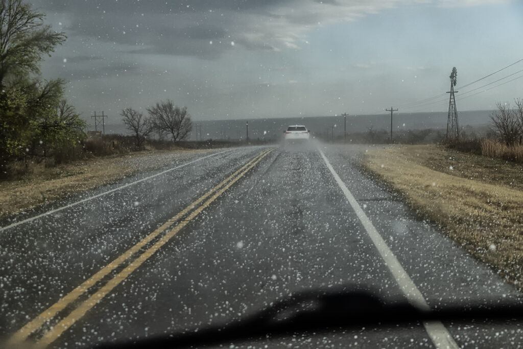
March 10, 2026 Northern Oklahoma Severe Warned High Based Supercells
Having to be in Great Bend, Kansas on March 10th kept us from going to Illinois for that event. Instead, we played a stationary boundary near the Kansas/Oklahoma border area. Storms formed mid afternoon west of Woodwards, OK and intensified as they traversed the boundary. By the time they got north of Alva, OK, they were producing copious amount of hail up to pingpong ball sized. We drove through the core a few times to see what it had in it and got some decent hail stones! We eventually let them go as they moved north of the boundary and became elevated supercells. We headed to Wichita, KS for the night and were greeted with tons of lightning and hail at our hotel. A fun way to spend the day on our way to get the new customized van for 2026!!!

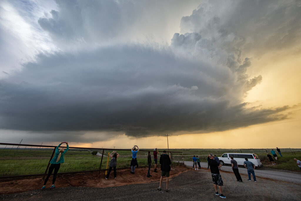
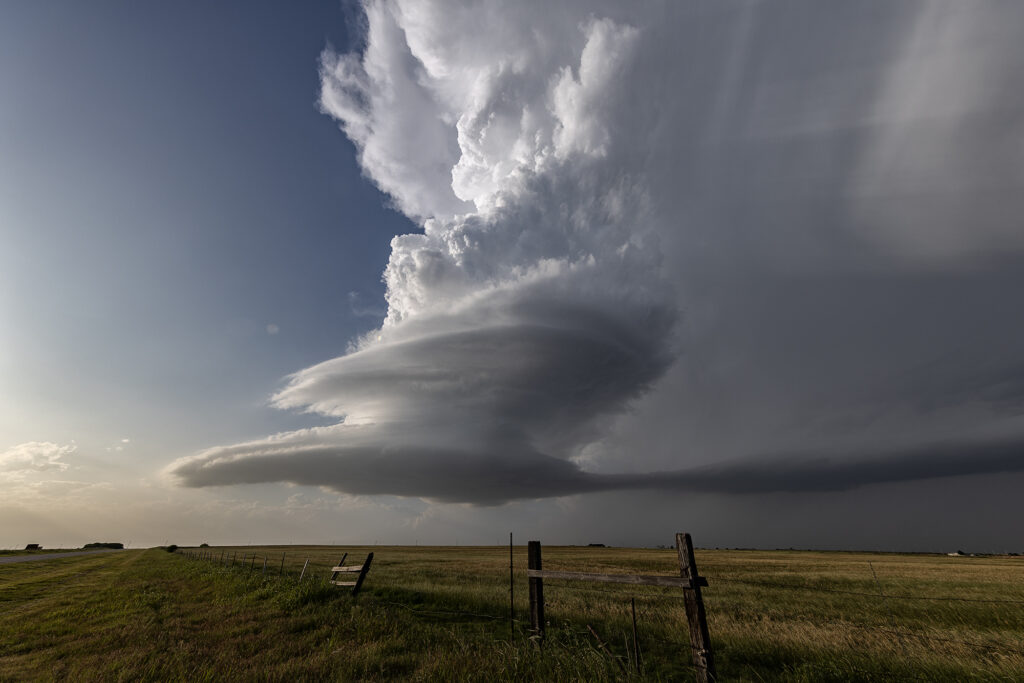
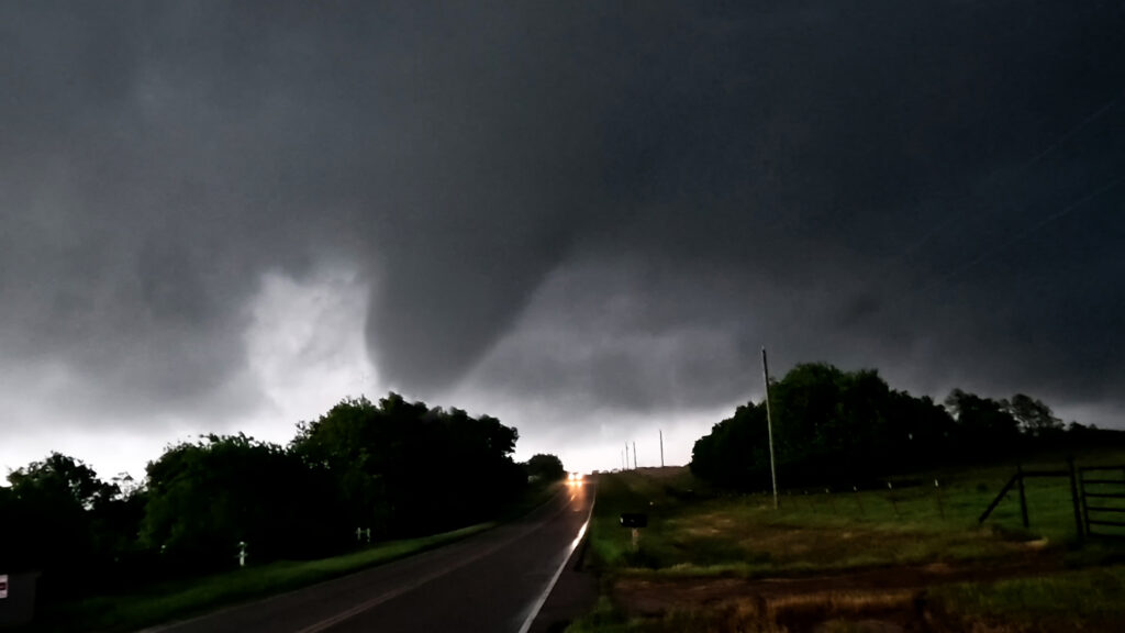
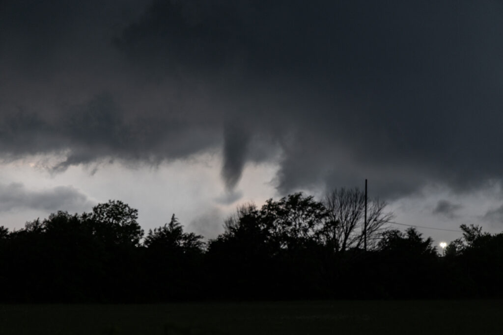
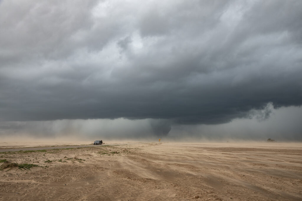
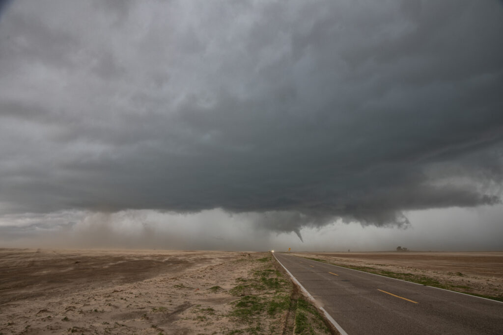
May 19th Butler, Oklahoma Tornadic Supercell
May 19th had a lot going for it. Good shear, instability and moisture, as well as a dryline in the eastern Texas panhandle set the stage for intense storms to form. By mid afternoon numerous storms formed and it wasn’t long before one updraft became dominant. Structure became quite good, and quickly a very slim tornado formed and disappeared in less than a minute. This just attested to the shear that was present. As the storm moved into Oklahoma, structure became amazing! A big soda can updraft with striations and a wall cloud were visible. As the storm approached Butler, it became tornadic and produced a cone tornado, near Custer City followed by w wedge north of Hydro. We got in intense RFD and had trees coming down around us, so we had to get out and move them ourselves so we could continue the chase. As we later past ElReno, we stopped at an exit and filmed the storm coming at us, complete with rapid rising and twisting scud, which soon a debris cloud appeared. We were trying to get through OKC and head north for the night and didn’t want to chase in the city as a substantial tornado touch down south of ElReno. Chasing at night is a challenge, but around a larger city, it is dangerous. We drove north to spend the night in Salina and get ready for the next day which would be a chase day. Enjoy the pics!
May 6th High Risk Oklahoma Chase
May 6th looked amazing on paper. All ingredients were well balanced and it appeared that a major tornado outbreak would occur. As the chase set up, models kept hinting at a rapid evolution to a line of severe storms instead of individual supercells. In the end the afternoon models are absolutely correct. The Storm Prediction Center issued a HIGH RISK for Oklahoma and the highest tornado probabilities that I’ve ever seen! As the old saying goes, sometimes too much of a good thing isn’t a good thing. Strong forcing would cause rapid line of storms to form. Most storms were tornado warned, but did not produce. We chased a half dozen tornado warned storms, but only one came close to producing near Canton, OK. We kept dropping to the tail end storm with no luck. Each cell would mature, with a fast developing storm on its flank causing the forward storm to become a cell embedded within a line. Storms need space to rotate and nature didn’t provide that this day. In the end, it was a total bust for almost all chasers, the SPC and local NWS offices. It just goes to show you that no matter what you think you know about the environment, nature knows more!

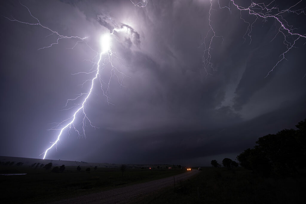
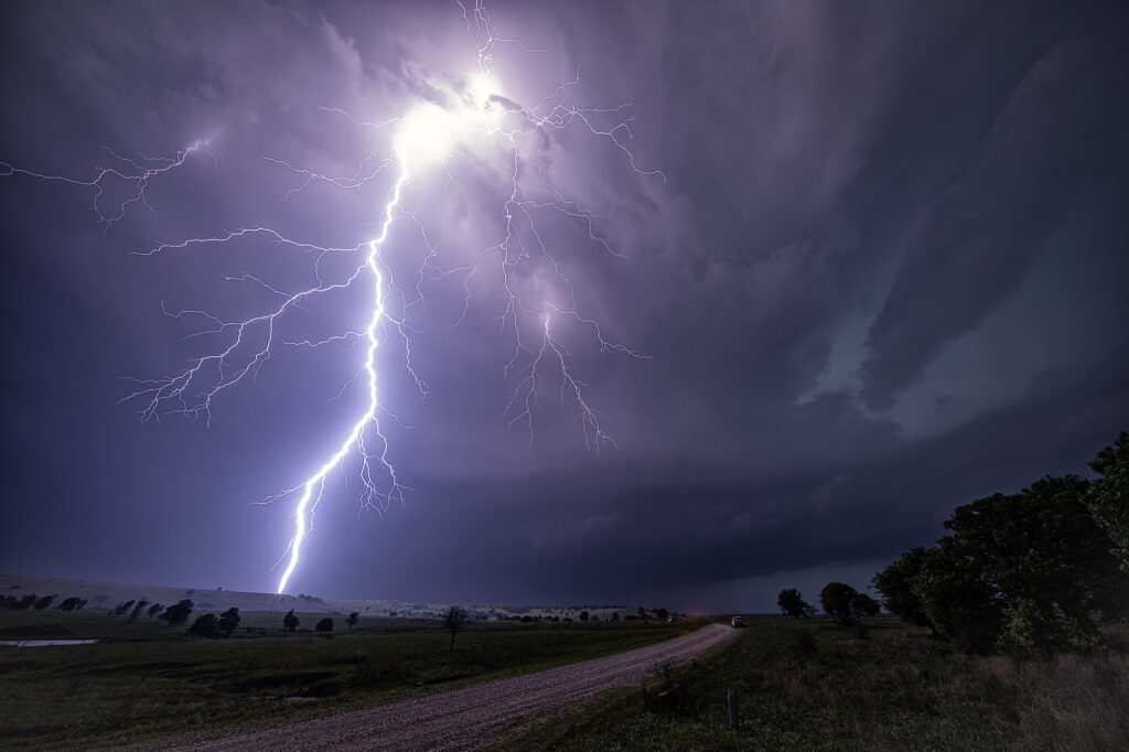
June 13th Texas Panhandle Tornado Warned Supercell
June 13th took us to the northern Texas Panhandle for supercells. By mid afternoon, storms for along the TX/OK panhandle border area near Boise City, OK. These storms moved slowly southeast and became supercells. Hail and high winds were the common theme with these storms, then southwest of Guymon, OK one became tornado warned. It didn’t produce but certainly tried as a funnel descended halfway to the ground. Never could confirm if it touched down or not. As the storm moved further southeast towards Stratford it did produce a small cone for a couple minutes. We were blocked by the police from getting close, so we had to drop south and east to get ahead of it. It was constantly tornado warned but had that outflow dominant look to it. We eventually stayed ahead of it to McLean, Texas and let it pass overhead. It produced giant hail 5 inches in diameter, and you’ll see in the pics just how huge it was! Fun day, but wow there were some fake tornado reports!
June 11th Raton Mesa, CO Tornado Warned Supercell
May 11th had a lot going for it. Good upslope flow into the Raton Mesa, decent moisture and instability and great wind shear would set the stage for supercells this day. Storms formed early afternoon and became tornado warned. We blasted west from the Oklahoma panhandle into the mesa in time to watch a supercell get very interesting. Couldn’t confirm any tornadic activity, but it certainly looked like it had potential. This storm also produced baseball sized hail and high winds. It was a treat to photograph and watch spin across the mesa into the Oklahoma/Texas panhandle. Fun day for all the guests who witnessed this beauty! Enjoy the pics!
May 11th Central Oklahoma Tornado Warned Supercells
Great potential on May 11th!! Good moisture and instability would occur, as well as lift along a dryline, would result in several tornado warned supercells and one that produced a couple of night time tornadoes near Noble, OK. We chased south of the OKC area early as a supercell formed. It eventually died off as it ingested dry air. However, north of that several storms went up and spun, becoming tornado warned. One storm took us towards Lindsay, OK and attempted to drop a tornado. The funnel came halfway down and receded. Structure was very pretty as the supercells became very well organized. In a weird ending, one of the first storms we chased dropped the tornadoes. This storm was in the middle of a line of supercells, which typically is unusual. Almost always chase the tail end storm that has no competition for air, but this was not the case today! Enjoy the pics!