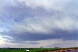
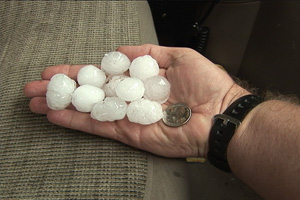
August 30th showed some potential for initially high based convection to get better organized as it moved east off the Palmer Divide into better moisture. That is exactly what it did. Nice upslope flow underneath 30-40 kts mid level westerly flow would provide strong enough shear for storms to become supercellular and produce large hail. Several storms developed on the eastern side of Denver, then most east into a line. However the tail end storm, as is often the case, became a nicely rotating supercell that produced hail to golfball sized. The structure was very nice with HP type characteristics. As the storms approached the Kansas border the dissipated.
May 29, 2006 South Central Kansas Severe Storms
May 29th was a higher instability but low shear day. Several pulse storms developed in Kansas, with a couple of embedded supercells. The prettiest thing about these storms was their electrification. They also produced hail to ping pong ball size.
April 23rd, 2006 Kansas Severe Thunderstorms
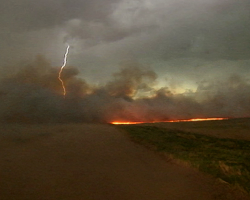
April 23rd was a day that had plenty of dynamics, but questionable moisture, as has been the case many times this spring so far. I caught an outflow domimant severe thunderstorm complex east of Dodge City early, then caught the best supercell of the day near Salina, as strong lift occurred near the warm front. The outflow dominant storms produced lots of lightning and strong winds, as shown above when lightning sparked an intense wildfire east of Great Bend. The Salina supercell was rooted in the boundary layer and tried hard to produce a tornado. It also produced hail to golfball size.
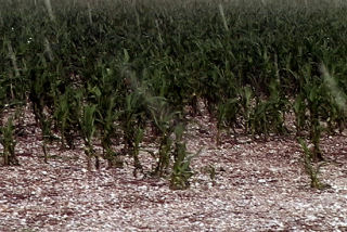
July 1st, 2005 Northwest Kansas Supercell
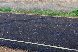
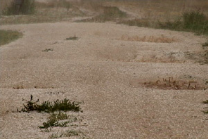
I didn’t expect much on July 1 with limited moisture and large temperature/dewpoint spreads. We did catch a nice high based hailer northwest of St Francis, Kansas. This storm had decent structure and produced tons of hail to golf ball size. Unfortunately this hail clobbered numerous cornfields and did considerable damage.
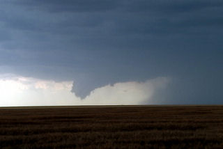
June 30th, 2005 Neosho County Kansas Possible Tornadic Supercell
June 30 was a surprise day! Things did not look that great to start, but intense instability along with an old outflow boundary would provide the focal point for severe thunderstorms. Elevated storms developed during the morning and early afternoon, followed by surface based storms along outflow boundaries later that day. We raced east from Wichita to catch this beast as it became an intense supercell. It produced at least one if not more tornadoes. One tornado was reported after we left it with a damage path of 500 yards!
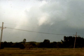
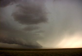
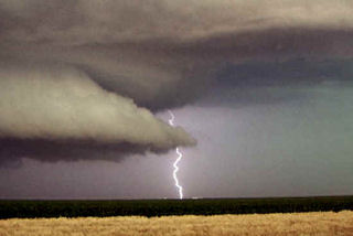
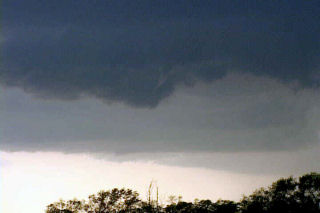
June 16th, 2005 Southwest Kansas Tornadic Supercell
This day was actually a surprise. An old outflow boundary across southwest Kansas into northwest Oklahoma would provide sufficient convergence and lift to develop supercells this day. One such beast developed near Garden City and intensified as it moved southeast. It produced a landspout and had beautiful structure.
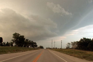
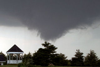
June 9th, 2005 North Central Kansas Tornadofest
June 9 had that feel to it. Everything was coming into place for a significant tornado outbreak. A triple point was situated over northwest Kansas, slowly drifting east. Very unstable, moist air was streaming in from the south, and with an approaching short wave trough, it was only a matter of time before rapid severe thunderstorm development would occur. I sat north of I-70, southwest of Hill City and watched the storm of the year develop from a small cumulus tower and become a prolific tornado producing monster.
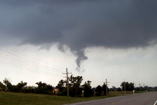
June 8th, 2005 Oskaloosa, Kansas Tornadic Supercell
I must admit, this day caught me by surprise. We started in eastern South Dakota. After morning analysis and looking at model data, it appeared to be a respectable chance for large supercells in eastern Kansas with extreme instability and decent shear. As we arrived in Jefferson county, Kansas a supercell exploded from a small cumulus tower. Within 20 minutes the top was at 60,000 feet. Within another 30 minutes a tornado formed. This tornado narrowly missed the town of Oskaloosa.
May 10th & 11th, 2005 Supercells & Tornado
An interesting period for May 10 and 11. I captured an incredible mothersip supercell May 10 near Grand Island . This storm formed on the triple point and became one of the prettiest supercells, structure wise, that I had ever seen. It almost immediately started rotating and became severe quickly after it formed. There were many reports of tornadoes with this storm, none of which I believe are true. It was fairly high based its entire life.
On May 11 we left Kearney mid morning headed south towards Stockton , Kansas . When we arrived it was 81/68 with a nice southeast wind early afternoon. We watched as soft towers would go up and get sheared over. We ended up chasing the cell that was tornado warned northwest of Stockton . These cells were high based, and not very organized. As they crossed front, they became even more elevated and did not much of anything.
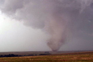
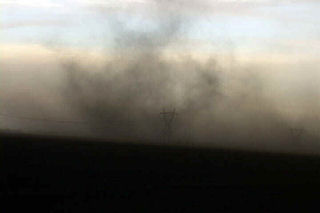
Mid afternoon we blew of this junk and headed west to the triple point as cell exploded there. We arrived near Benkelman and came over a hill to catch a glimpse of a weak skinny tornado west of town. The storms looked linear somewhat with a shelf cloud racing northeast. Updrafts were visible behind the shelf. Then something weird happened. My temp and dewpoint went from 63/59 to 71/64 in a matter of 1 minute. All of a sudden an updraft base starting rapid cascading motion, then rapid anticyclonic twisting and turning. Then a loud waterfall sound formed and a few seconds later a tapered cone funnel formed almost overhead. As quick as all the happened, less than a minute, a debris cloud formed in a field just to the southwest of the van. RFD hit the van on the NORTH side of the tornado, which we determined WAS anticyclonic!
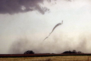
We blasted north away of this northeast moving tornado as condensation developed to the ground. Our view out the west side of the van was one of condensation lifting with multiple vortices twisting and turning as debris, old corn stalks and tumbleweeds went flying up and rapidly rotating around the vortex! This tornado was no more than 100 yards from us and closing. We drove at a fast pace to get away from this tornado and managed to get a quarter mile away and we stopped. It immediately dissipated as the funnel rapidly vanished. This entire sequence happened in 3 minutes!
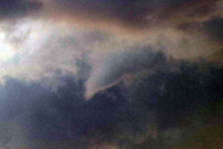
April 10th, 2005 St. John, Kansas Supercell & Funnels
April 10 was a day I wouldn’t soon forget. We had to leave Denver early to escape a raging blizzard. We were able to get out in front of it and into the warm sector under sunny skies. This was a tough day forecast wise for me as it looked like the dryline bulge would be the place to play. We later discovered too much dry air and a perpendicular orientation of the mid level winds to the dryline would cause the storms to form in a line instead of discreet supercells. Too much dry air never let the storm updrafts get organized for long periods. Later we also found out about the tornadoes in Trego county, to our north. We had actually taken off from the Pratt area to head back north and play that spot, but changed our minds. Live and learn. Thank goodness it is early season!