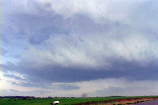
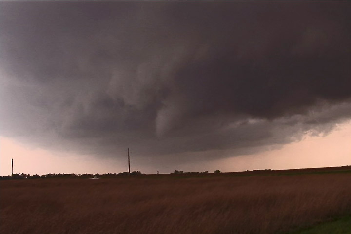
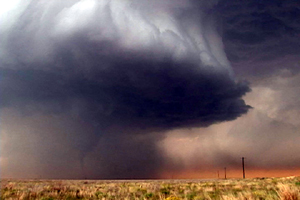
June 21st was a day that had great potential. Very good shear, moisture and instability were in place across the high plains into the western Dakotas. An approaching shortwave trough would provide the necessary lift to spark intense supercells in southeastern Montana. One particular supercell formed near Baker, Montana and cycled several times as it entered northwest South Dakota. This storm would be responsible for a half dozen tornadoes we witnessed across northern South Dakota. The first tornado occurred as the storm really ramped up near Ralph, South Dakota. It would cycle several times and keep producing tornadoes all the way to near Eagle Butte where it dissipated late evening. The structure was some of the best of the season and several tornadoes were quite photogenic! Tour 8 scored big with this gorgeous beast!
May 5th, 2007 Kansas Tornadofest
May 5th was a High Risk day from the SPC. Everything seemed to be coming together for a significant tornado outbreak. We decided to target storms in southwest Kansas east of Dodge City. A strong dry punch, intense wind shear and strong instability would set the stage for tornadic supercells. Storms struggled till early evening with the strong shear ripping apart about any storm that tried forming. Finally a supercell developed near Pratt that became tornado warned. It produced a weak tornado and many funnel clouds. About an hour later, several supercells developed and produced numerous tornadoes. We were able to intercept 6 more tornadoes, including a few that were strong.
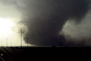
March 28th, 2007 Texas Panhandle Tornado Outbreak
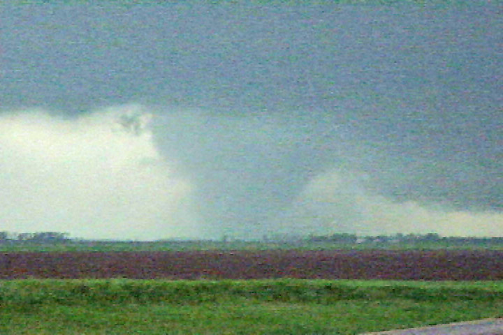
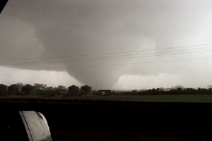
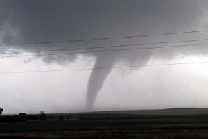
March 28th was a day many storm chasers will never forget. An unusually strong and deep system was crossing the Rocky Mountains with intense lift, deep moisture, incredible shear and good instability headed towards the southern and central high plains. This would set the stage for what would become one of the most prolific tornado days in the high plains ever recorded in March. All in all I caught 8 tornadoes this day with 3 being quite photogenic and quite strong. A total of 65 tornado reports were submitted to SPC. Two different supercells spawned killer tornadoes. I have many still photos and a few video captures of the tornadoes we intercepted below. The first two tornadoes we could not get photos of as they were too far off near Silverton, Texas. We were on a hard intercept course for that supercell and couldn’t get there in time to get good photos. Both tornadoes were slender elephant trunk shaped tornadoes. Then a 3rd tornado formed, a multivortex tornado, northeast of Silverton and that is where my first video capture was taken. After that supercell moved northeast, the developing tail in storm became quite a dominating monster. We caught 3 or possibly 4 tornadoes from that storm. Finally, as that cell moved northeast towards Miami, Texas, we could see a lightning lit very large wedge tornado to our distant north. This final tornado derailed a train and did some minor damage.
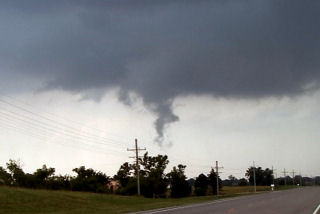
August 24th, 2006 South Dakota Tornado Outbreak
What an event!! After watching model run after model run I couldn’t resist the 1700 mile round trip to eastern South Dakota from Denver to chase this one!!! I arrived in Sioux Falls, SD around 3 PM. I couldn’t decide whether to sit tight, head to southern Minnesota or head west towards the advancing front. Each situation had its positives and negatives. After much analysis and some very quick driving, I decided to head west towards the front, which now was firing a string of supercells along it. I targeted the southern supercell coming across the Missouri river north of Pierre. I caught up with it east of Oneida and what a sight it was!!! It took about 10 minutes for it to drop its first of 7 tornadoes that I saw. The structure was second to none as this beautiful striated updraft produced one tornado after another. The largest and strongest tornado developed southwest of Wessington and tracked southeast near Wolsey to southwest of Huron before dissipating. It stayed on the ground over 40 minutes and resembled the Manchester, SD tornado from June 24, 2003 (which I saw from the south side). Finally, the storm produced one last tornado southeast of Huron as it weakened moving towards I-29.
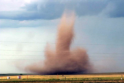
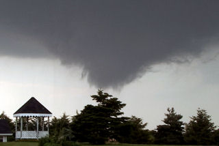
August 20th, 2006 Bennett, Colorado Tornadoes
I wasn’t planning a chase this day. However, as the afternoon progressed an outflow boundary raced south from convection in Wyoming, and intersected the DCVZ boundary that was quite evident running from Bennett to Prospect Valley, Colorado. Good instability, weak shear and the boundary would provide a perfect set up for non-supercell (landspout) tornadoes! And the atmosphere didn’t disappoint! By 5 PM a VERY nice line of towers exploded along the boundary. By 6 PM I had seen 3 funnels. At 6:37 PM the first tornado touched down 4 miles north of my house. It stayed on the ground for 20 minutes before dissipating. The second tornado touched down at 6:54 PM and stayed on the ground for 9 minutes. It was much larger than the first, but outflow from the downdraft of the first cell would kill this tornado much sooner than the first one. At one point in time both were on the ground !
May 5th, 2006 Patricia, Texas Supercell and Tornado
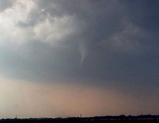
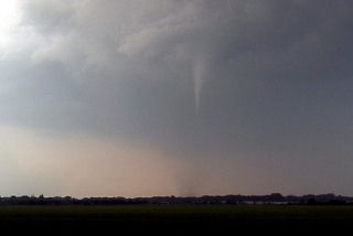
May 5th took us to the southern Texas panhandle for what looked like a decent supercell and tornado day. Strong southwest flow aloft on top of southeast surface winds along an outflow boundary would set the stage for tornadic supercells. By late afternoon storms developed near Hobbs, New Mexico and intensified as they moved towards Seminole, Texas. The main cell entrained too much dry air and struggled until it moved off the dryline. At that point a monster updraft developed and spun like a top. A nice stovepipe shaped tornado formed back in the hail and rain northeast of the clear slot.
June 29th, 2005 Southwest Minnesota Tornadoes
The set up this day was conducive to supercells. A dryline/cold front would advance across far western Minnesota and provide the focal point for thunderstorm development. We started in west central Minnesota north of Marshall. Convection developed and went linear quickly. So we dropped south where the cap was stronger and caught a nice isolated supercell. This storm produced at least 2 tornadoes we could confirm.
June 8th, 2005 Oskaloosa, Kansas Tornadic Supercell
I must admit, this day caught me by surprise. We started in eastern South Dakota. After morning analysis and looking at model data, it appeared to be a respectable chance for large supercells in eastern Kansas with extreme instability and decent shear. As we arrived in Jefferson county, Kansas a supercell exploded from a small cumulus tower. Within 20 minutes the top was at 60,000 feet. Within another 30 minutes a tornado formed. This tornado narrowly missed the town of Oskaloosa.
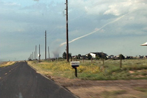
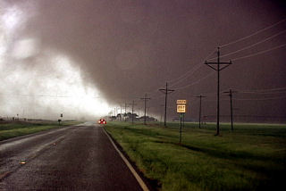
May 12th, 2005 South Plains, Texas Tornadoes & Hailstorm
It was the day in between tours and Dr Dave Gold rallied the troops to meet me in OKC early. We didn’t get out the door till 1 PM, headed southwest towards the triple point near Plainview. By 3 PM we were hearing of tornado reports and the Baron system showed a nice supercell near Plainview. I thought we would get storms firing off that boundary most of the afternoon, but never figured on what we saw.
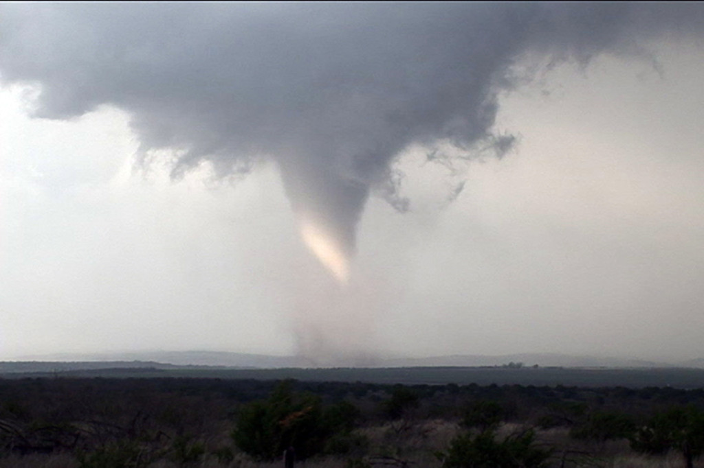
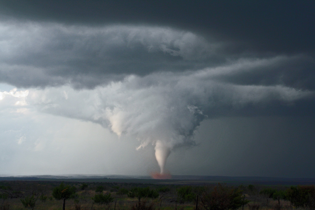
We arrived southeast of Silverton by 5 PM and watched as the eastern supercell spun and tried hard, but developed outflow problems. We finally blew it off and headed through Silverton and south towards South Plains. The storm looked MONSTROUS and very HP. As we approached 207/689 intersection a tapered elephant trunk tornado formed just to our southwest. This tornado widened and strengthened as it moved east across 207. We SLOWLY drove south as it approached the highway, and at one point were about 200 yards north of it, getting the best contrast we could get. We had a Japanese film crew with us who had a probe similar to Tim Samaras’s, and they were able to drop it in the path of this tornado. The footage was INCREDIBLE!
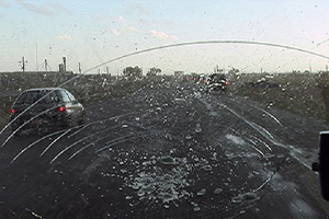
The tornado crossed 207 and dissipated about one mile east of the highway. According to my time stamp on my camcorder, it was on the ground for 12 minutes. Many power poles were down, blocking 207, with some out buildings destroyed. It missed South Plains by about 2 miles or it could have been devastating!!! A second broad circulation developed about two miles east of the first tornado and a multivortex tornado formed. The motion in the cloud base and the tornado was horrendous!!!!! At one time I counted 4 vortices in this tornado. Then the real fun started as we were getting softball sized hailstones wrapping around the back of the tornadic circulation. It dissipated after about 5 minutes. Due to softball sized hailstones, we stopped and to seek shelter in a farmer’s tin carport. Then we had to sit and watch as baseball to softball sized hail took the farmhouse apart, along with trees and two windows in the van as we couldn’t get it totally under the shelter. One of the most prolific hailstorms I have EVER witnessed. Then we took off and headed east to Childress and watched the fantastic CG display with this monster!
April 10th, 2005 St. John, Kansas Supercell & Funnels
April 10 was a day I wouldn’t soon forget. We had to leave Denver early to escape a raging blizzard. We were able to get out in front of it and into the warm sector under sunny skies. This was a tough day forecast wise for me as it looked like the dryline bulge would be the place to play. We later discovered too much dry air and a perpendicular orientation of the mid level winds to the dryline would cause the storms to form in a line instead of discreet supercells. Too much dry air never let the storm updrafts get organized for long periods. Later we also found out about the tornadoes in Trego county, to our north. We had actually taken off from the Pratt area to head back north and play that spot, but changed our minds. Live and learn. Thank goodness it is early season!