Tag Archives | funnel

June 24th, 2003 South Dakota Tornadofest

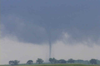
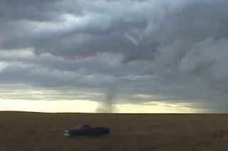
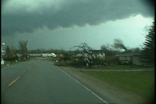
Some days you never forget. This day was to be one of those days. I spent the night in O’Neill with my tour and my fiancé Caryn who had yet to see a tornado. This was to quickly change. Morning analysis showed a well defined boundary along the NE/SD border extending east/west. This boundary slowly drifted northward into South Dakota by early afternoon, as did we. Cells started developing west of me in the hot air, but we waited patiently near Pickstown, SD. By 3 PM, it was evident we needed to go north to near I-90 and the Mitchell area. As we drove north, a supercell rapidly developed just west of Mitchell. By the time we could get the base into view, a huge block wall cloud was visible. Soon, a large cone tornado formed west of Mitchell, south of I-90. We approached the tornado to our north, but were a good 10 miles from it as it roped out, while another weaker tornado formed after the occlusion to the east. By the time we reached updraft base, the show was over. But we did manage to catch a couple decent views of both tornadoes.

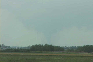
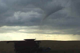
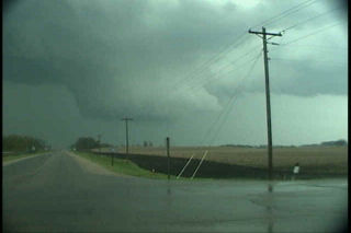
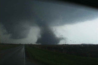
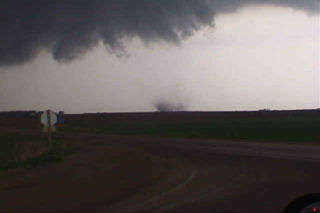
Next, I noticed an explosive updraft northwest of town. We raced northwest towards the town of Woonsocket and as we approached a truncated cone tornado formed. This tornado morphed into a large stovepipe, then elephant trunk, then stovepipe again as we watched from 1.5 miles east of it. A GORGEOUS tornado to say the least. After 12 minutes, it dissipated. The occluded updraft died, as a new meso formed to our northeast. However, now the road options were pathetic with only dirt and gravel roads to use to keep up with the storm. As we zigzagged across the countryside northeast of Woonsocket, another supercell was developing farther to our east. It quickly dropped twin tornadoes about 8 miles east of us. We decided to abandon our efforts on our shriveling storm and go after this intensifying tornadic supercell south of Iroquois, SD. As we maneuvered muddy dirt roads, another tornado formed under the new storm. This nice rope tornado was about 5 miles to our east. As we got closer, now about 6 miles south of Iroquois, a multivortex tornado formed along with a small satellite tornado. What a sight!!!!!!!

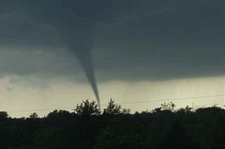
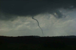
I decided to get the tour closer, so we raced up to Iroquois, then east of highway 12 toward Manchester and DeSmet. I knew we would have to punch the hook of the storm and warned everyone what we could find as we punched it. Sure enough, just west of Manchester a VERY LARGE tornado had just crossed the road about 300 yards in front of us. This tornado was very violent. As it ripped the town of Manchester apart, we sat in awe as the tornado dropped tons of debris all over the countryside. It moved north of Manchester and continued to be a violent tornado (rated F4) as it went through a long rope stage. Finally it roped out as we decided to head towards DeSmet. Another multivortex tornado quickly formed after yet another occlusion and stayed on the ground for 4 minutes. Finally, northwest of DeSmet the last and very photogenic tornado occurred and last nearly 15 minutes!!! What a day!!!!!

June 11th, 2003 Lyman, SD Supercell

June 11 took me to South Dakota for another promising day. The conditions this day were similar to June 9 which produced several tornadoes, however the models were consistent in bringing a bit less moisture to the region. This would be the big factor this day in my mind why we did not get a tornado to form. Cloud bases were too high for any significant tornado development. However the storm was a beautiful supercell and had wonderful structure. It produced 3″ diameter hail, several funnel clouds and intense lightning.

July 26th, 2001 Arapahoe County, CO Tornado

July 26 was a day with good possibilities for eastern Colorado. Decent shortwave energy was present, along with good instability and the DCVZ boundary setting up in eastern Arapahoe and Adams counties. I headed out the door shortly after lunch with a target to get under developing thunderstorms near the Byers area. Upon arrival just east of Byers, a nice cell had developed and was racing northeast rapidly away from me. Another cell was developing southwest of town, and this cell was the one I targeted. By 2 PM, a nice bell shaped, candy cane striated mesocyclone developed on the eastern side of the storm. Soon, rapid rotation was evident. At 2:28 Pm the tornado touched down and stayed on the ground for over 10 minutes. Overall a very nice storm and I fortunately got the results I had hoped for.

May 6th, 2001 Oklahoma Tornadoes

May 6 was an incredible day. It was to be the “day after the big day” type scenario. On May 5, a couple of weak tornadoes occurred, but did not destroy the set up for May 6. The morning models showed an explosive situation with over 5,000 j/kg of CAPE, strong westerly 500 mb winds across southern Oklahoma, and an old boundary. We headed south towards the Ardmore area to play the better shear, and much to our dismay, severe thunderstorms developed back in Oklahoma City where we had come from. The temptation to go back and chase these cells was short lived as two explosive supercells developed in a north/south line from Springer to Overbrook. The first storm produced the first tornado below, an F2 that was gorgeous. The second storm also produced an F2 near the town of Overbrook. Finally we ended up near Denton, Texas chasing a gorgeous LP supercell that is shown in the last photos.

May 1st, 2001 Glenville, Minnesota Tornadoes

The day of May 1, 2001 will live a long time in my mind. The day started out with a potentially explosive situation in northwest Iowa and southwest Minnesota. A strong low with associated warm front was approaching the area from South Dakota, as well as a pronounced dry punch from Nebraska. Our thoughts were to get in position at the nose of the dry punch. Several tornadic supercells developed in Minnesota before we could make it there. However, little did we know that the tail end storm, the Glenville storm, was to be the most spectacular show of the day, and maybe of the season. The cell developed in Winnebago county, Iowa and intensified as it crossed the border into Minnesota. It rapidly developed one of the most incredible large rotating wall clouds I have ever seen, followed by an awesome tornado. Unfortunately it hit parts of the town of Glenville. A second even larger tornado developed after an occlusion near the town of Austin, Minnesota, followed by a third “Wizard of Oz” type tornado near Rosebud, Minnesota.

May 11th, 2000 Dunkerton, Iowa F3 Tornado

This is the second damaging tornado from the cyclic supercell on May 11, 2000 in Blackhawk county, Iowa. This tornado formed to the southeast of the decaying original tornado and ended up damaging part of the town of Dunkerton. Unfortunately, Dunkerton had been damaged in 1999 by floods, and now was to suffer again only a year later. The tornado traveled in a northeast direction and clipped the western side of town causing up to F3 damage to some buildings.