Tag Archives | elephant trunk

May 22nd, 2004 Nebraska Tornadofest

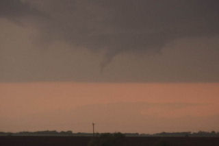
May 22 took me to Nebraska. All things were coming together for quite a severe weather episode. A strong dynamic low and associated trough were coming out of Colorado headed for southern Nebraska. All severe weather indices were pointing to the area southeast of McCook, eastward towards Fairbury. Enough shear, instability, moisture and lift were present for strong tornadic supercells, and the atmosphere did not disappoint. By early afternoon, severe thunderstorms erupted in Colorado and spread into southwest Nebraska. We blasted westbound out of Hastings towards the tail end supercell southeast of McCook. We arrived in Beaver City in time for the show of the day. A quick tornado developed as the storm ingested deeper moisture, however this would be just the beginning.

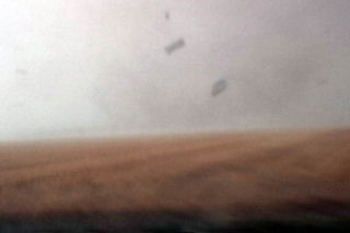
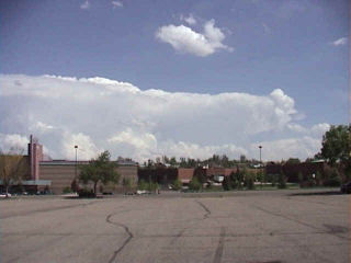
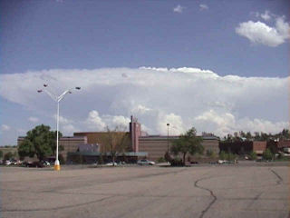
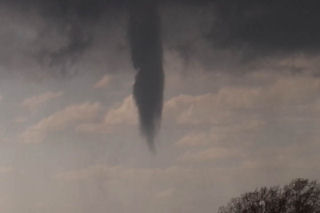
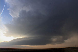
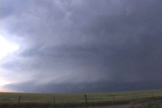
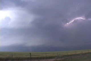
Soon, a strong tornado developed just south of town and stayed on the ground for about 15 minutes. This was a beautiful elephant trunk/stovepipe that did little damage. A second tornado formed after an occlusion near the town of Orleans. This tornado just missed the north side of town. We are parallel with the tornado its entire life cycle. Just east of town I got out of the van and video taped as the tornado churned about 200 yards north of the road. It hit s building and filled the air with debris. I jumped back in the car and we drove east as it dissipated. In the meantime another tornadic storm (near Hallam, NE) formed. As we tried in vain to catch it a another storm formed near Republic, Kansas. This storm would produce 3 tornadoes, one of which was fairly strong. The updraft structure was breathtaking!!!! Finally at dark the last tornado formed with this storm as we blew it off to get ready for Illinois the next day.

May 10th, 2004 Elbert County, Colorado Tornadoes

May 10th actually brought me to Oklahoma City for the end of tour 1 and the beginning of tour 2. Morning analysis indicated a strong potential for supercells and possible tornadoes in Colorado near the Palmer Ridge south and southeast of Denver. By mid afternoon storms developed near I-70 along a convergence zone. After a couple hours of struggling, on supercell became the dominant storm and produced up to 9 tornadoes. I called my wife Caryn to see if she wanted to chase the developing situation and out the door she went!!! Camera in hand. I vectored her to north of Limon where she encountered the first of many tornadoes. After videoing 40 minutes of tornadoes, her camcorder battery died as a large wedge tornado formed. Finally, near dark the last elephant trunk tornado formed northeast of Limon and was backlit by lightning. The photos below are just the beginning of this page dedicated to this event.

March 27th, 2004 Edwards County, Kansas Tornadic Supercell

March 27 took me to southwest Kansas. A triple point set up was to be the focus for initial supercell development this day. Models showed a couple waves of convective development with the advancing trough and cold front with the dryline and triple point to be the focal point for potential tornadic supercells by late afternoon. However, the first wave of convection of the day, which developed late morning and early afternoon, was the only wave to happen. Fortunately I left early for my target of Dodge City, Kansas. After driving through blizzard conditions in Colorado, I got in front of the advancing cold front just west of Ogalla, Kansas on I-70. I dropped south to get to my target, and at the same time a supercell developed just east of Dodge City.  This storm rapidly intensified and produced several tornadoes. I had to core punch the FF core to get to the updraft and managed to break my first windshield of the year with 2.5″ diameter hailstones. By the time I got to the updraft, the first LARGE tornado (F3) was dissipating. I managed to see it as it dissipated, but missed the biggest action by 10 minutes. Two other tornadoes and several funnels formed. Also included in the photos, was an LP supercell from the night before that my wife Caryn and I intercepted near Boise City, OK. Check out the photos below.

May 23rd, 2002 Borger, Texas Supercell & Tornado

What an incredible storm this was!! After spending almost too much time east of Childress, we drove northeast and were greeted with this beautiful storm. From a distance it did not look that impressive. But as we approached it from the south, the incredible structure of this HP/classic supercell became obvious. This was a special storm!!! One of the top 10 in my book ever! From the highly striated liberty bell updraft, to the FF tornado it produced, this storm was a force to be dealt with carefully. We drove northeast of Skellytown and ended up northwest of Pampa to get the best view we could. And what a view it was!!!!

The FF of this storm was very electrified. The striated updraft had clear evidence of major RFD erosion, and I am afraid it produced a rather large rain wrapped tornado that was just out of vision. As the rain cleared the occluded updraft, a rather large block shaped lowering was visible which could have attested to producing a large tornado that we just couldn’t see. Enjoy the photos of this beast.