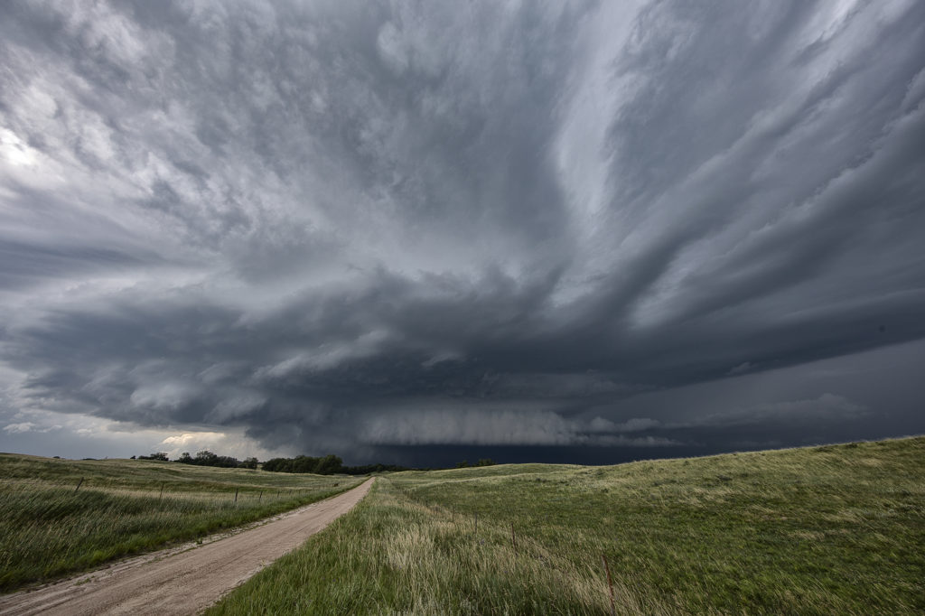
Although June 2nd didn’t look like a tornado day (and it wasn’t), we were hoping for some pretty storm structure. Limited moisture, but steep lapse rates and high CAPE would provide the ingredients to get storms to form. Moderate deep layer shear would cause storms to spin and look nice. They also produced copious amounts of lightning and very large hail to baseball sized. We intercepted a very nice supercell near Sargent, Nebraska that sat anchored along a stationary front for hours. Structure was quite nice with the striated “stack of plates” look to the updraft, and it even produced a couple of shear funnels at cloud base. Since they were very slow moving, we were able to sit and watch for long periods of time. Eventually, they gusted out as we left to head to our hotel for the night. A fun day and a bit better than I was planning on. Enjoy the pics!

June 25th Whitman, Nebraska Incredible Supercell and Strong Tornado
June 25th had a lot going for it. Dewpoints in the 70s, an old outflow boundary, high CAPE and convergence would get storms exploding in the afternoon hours. We targeted a pair of severe storms west of O’Neill, NE and watched them intensify and move south. However the western most storm quickly died when it moved over the boundary and the second one also met the same fate. Meanwhile towards Norfolk a supercell became tornado warned and produced a brief tornado. I always watch trends in surface observations and satellite and noticed the boundary sharpening up and angling towards the northwest to the west of us. Moisture was rapidly increasing with dewpoints in Thedford, NE rising from the low 60s into the low 70s with strong easterly winds. Soon, a storm formed along the boundary northwest of Mullin and anchored for awhile. It steadily intensified as we blasted west. By the time we got to Thedford, the storm was strongly severe and we could see an impressive mammatus field under the anvil. As we continued westward to get a better view, the storm formed a strong couplet and a hook. Structure was starting to become visible as we approached Mullin. We continued west and soon were greeted with a magnificent sculpted supercell and a rapidly growing tornado! The tornado grew to an impressive cone, then wedge as it moved south towards the small town of Whitman. We stopped about 3 miles from it as it was getting ready to cross the road and continue southward where we had no south roads! Frustrating! The sight of both the supercell with large tornado under was the best I’d seen in 2024!! Just an amazing scene! We had to back track to Mullen and drop south so we could catch up to the supercell again. We would not see the updraft again in the daylight. As it approached North Platte, it weakened and eventually died. An absolute phenomenal day! Unfortunately the tornado hit a couple of houses near Whitman and caused significant damage and 1 injury. I shudder to think what could have happened if it hit the town directly!
Check out our Youtube video from the even here:
https://youtu.be/Zx9_R1aMxQ0


June 16th McCook, Nebraska Gorgeous Supercell
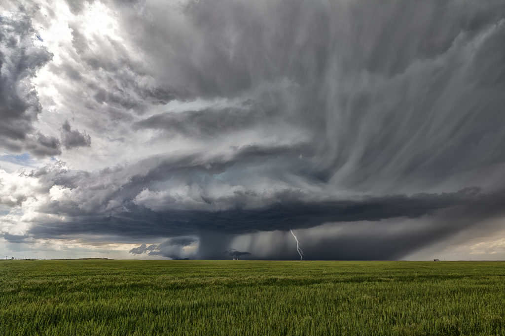
June 16th brought us to southwest Nebraska near McCook. A triple point focused potential storm development in the area with extreme heat (temps over 100) along the dryline with dewpoints near 70 along the warm front. Many updrafts tried to form in the area near the triple point, with one updraft succeeding in sustaining itself at the triple point. The storm sat and spun for several hours. The structure was quite pretty and periodically the storm produced copious amounts of lightning. Although never a real threat to produce tornadoes due to higher cloud bases, a couple of wall clouds formed and one bowl spun for several minutes. The storm persisted towards sunset then slowly weakened as it drifted slowly northward. An exceptional day based on how model portrayed the set up. Enjoy the pics!


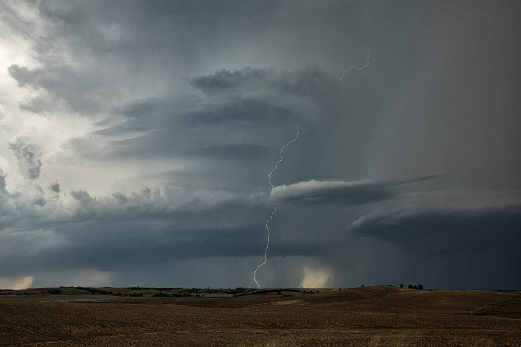
June 7th Ansley, Nebraska Tornado Warned Supercell
June 7th featured good moisture and instability, as well as moderate shear. A boundary lay across central Nebraska and would be the focus for several supercells The storm we chose to chase formed early afternoon near Thedford, and intensified as it moved southeast. By the time it got close to Broken Bow, it was well structured, producing baseball sized hail and a possible tornado. We followed it through town and southeast as the structure truly became insane! As it approached Ansley, it became tornado warned, but did not produce I feel low level shear from cloud base down was insufficient to produce tornadoes. Nonetheless, the structure was quite nice as it moved all the way to I-80 by mid evening. Enjoy the pics!!!


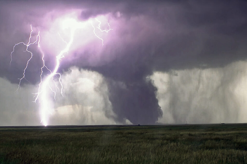
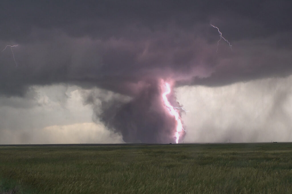
June 28th Kimball, Nebraska Large Tornado
June 28th had a lot going for it. Good moisture, strong instability, superb wind shear and the upslope play of the Laramie Range in southeast Wyoming. A supercell formed mid afternoon and became an electrified beast! As the storm spun east/southeast, it produced huge hail baseball sized, but never really was a tornado threat. As it moved into far southwest Nebraska, it encountered better moisture which allowed the cloud base to come down. That helped the storm tap into greater low level wind shear and develop rotation. A couple of funnels occurred before a rather large, dusty tornado formed about 8 miles south of Kimball. The tornado was on the ground for over 10 minutes as it moved slowly southeast. The storm continued to spin strongly off the Cheyenne Ridge into far northern Colorado. It weakened for a time and then reintensified east of Sterling. It continued its slow march to the east, now producing huge hail and flash flooding. We let it go at that point and went to the hotel after shooting lightning for awhile. Crazy fun day and thankfully the large tornado stayed over open lands. Enjoy the pics!!!
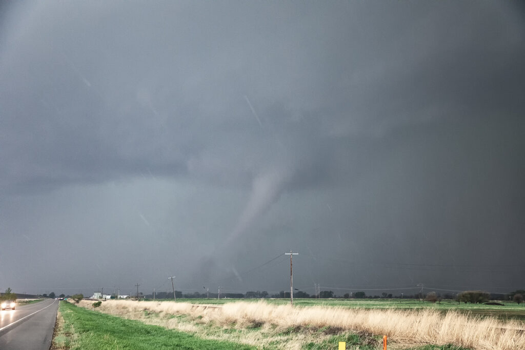
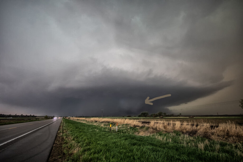
May 12th Nebraska Tornadoes
A great set up on May 12th took us to an arching boundary across central and eastern Nebraska. Early day storms produced weak tornadoes over north central Nebraska, but since our target was further east, we decided to wait it out for what we hoped were more violent storms. The wait paid off and numerous storms formed, almost all tornado warned, from northwest of York to north of Lincoln. One particular storm became violently tornado near Scribner, NE as we watched it produced a large partially rain wrapped wedge, then another elephant trunk shaped tornado in front of it. The wedge was rated EF-2 and the elephant trunk EF-1 as they hit a few structures, but fortunately nobody was killed. It was a murky day with a lot of low level moisture in place so apologies for the murky looking photos! Enjoy!
July 16th Central Nebraska Tornado Warned Supercell
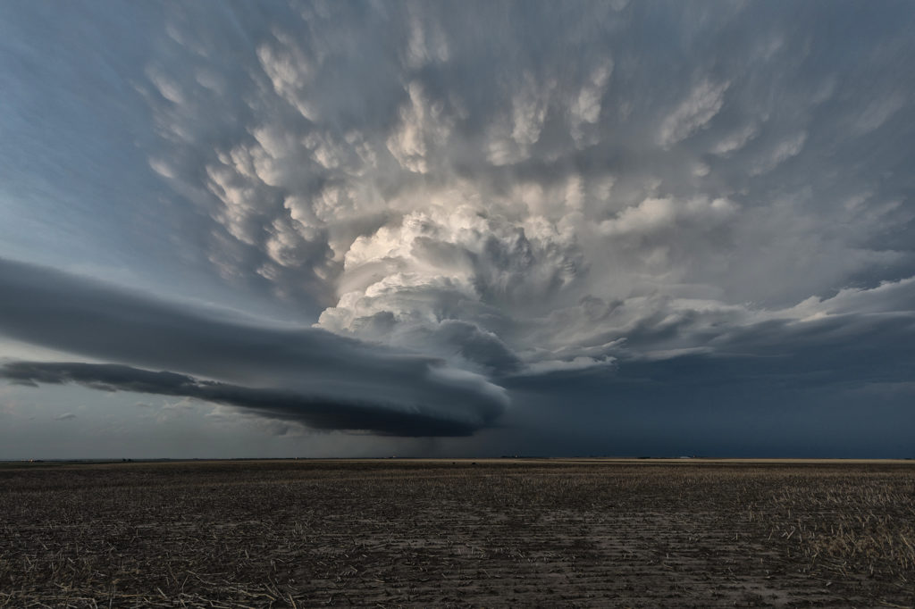
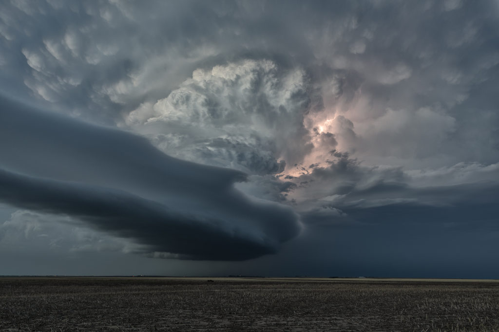
July 16th featured very high dew points in the mid 70s and CAPE values over 3000 j/kg. Shear was modest, so we weren’t certain we would get supercells. An early day supercell over eastern Nebraska laid out an outflow boundary over central Nebraska from Valentine southeast towards Grand Island. Storms formed along this boundary and moved east into the cool stable air and died. Later in the afternoon a cluster of storms formed on the boundary and the tail end storm anchored. It immediately started spinning and became a formidable supercell! As the storm right turned on the boundary and moved towards Burwell, it was rotating strongly and was extremely electrified! I thought it had a decent chance to produce a tornado, but it did not. A couple of weak funnels did form. As the storm continued southeast, it became tornado warned with strong rotation continuing. Another supercell formed west of this and rotated down towards I-80 near Gibbon and also became tornado warned. The structure was incredible with one of the best shelf clouds I’ve seen in years! As the storms pushed south of I-80, they gusted out and became a wind machine. A great day with far better results than we were expecting! Enjoy the pics!
June 14th Lincoln, Nebraska Nocturnal Tornadic Supercell
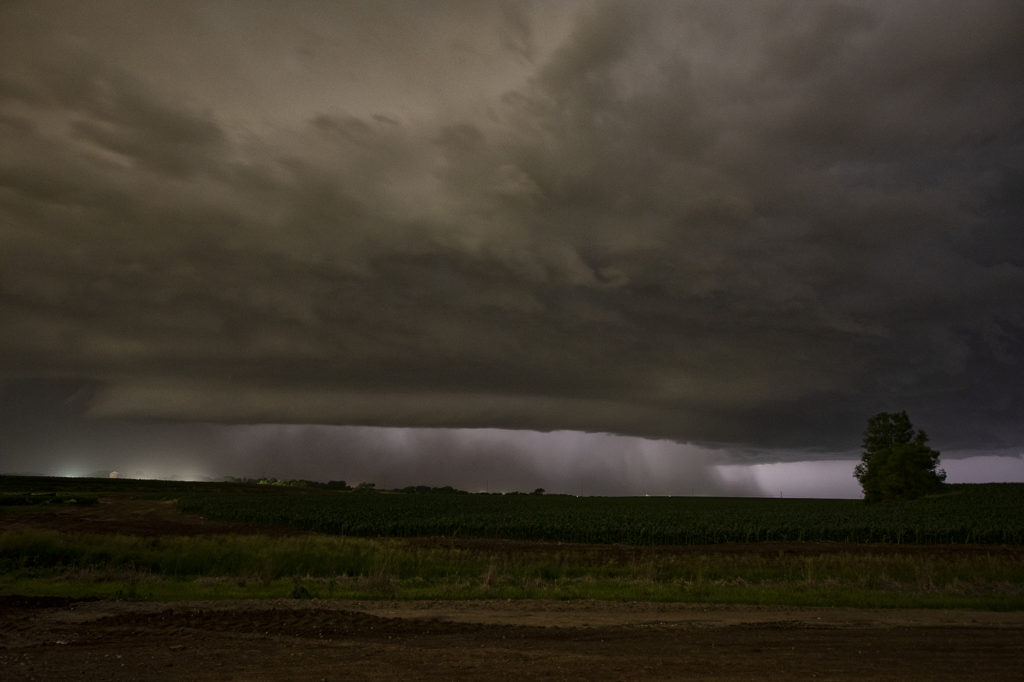
We weren’t expecting much on June 14th. Things were mistimed, moisture was iffy and instability lacking. Storms eventually fired early evening towards Grand Island along a front and moved eastward. They started out high based and lowered as the temp/dew point spreads lessened. West of Lincoln by mid evening, a supercell emerged and started really rotating strongly. A tornado warning was issued as the storm moved east and developed a strong couplet. (An EF3 tornado was confirmed later!) As the storm approached the north side of Lincoln, it wrapped in rain and was a very dangerous supercell. You couldn’t see what was going on in the notch and we didn’t dare go north without an escape route to look down the notch. We had to let it go due to timing and lack of roads. It moved east and recycled again becoming tornado warned. Some damage was recorded east of Lincoln, but at the time of this writing it was not confirmed whether it was tornadic or RFD winds. Certainly a surprise event and thankfully no fatalities occurred!

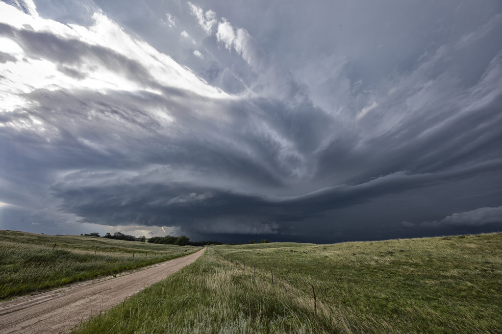
June 9th Southwest Nebraska Gorgeous Supercell!
June 9th had one target for us, southwest Nebraska. An existing boundary would be the focal point for storm development that afternoon. Numerous storms formed, several becoming severe, however only one would survive and be the storm of the day. This supercell formed south of North Platte, NE and turned hard right, spinning like a top all the way to Oberlin, KS. The structure was top notch. When it first got its act together, it did have a slowly rotating wall cloud. We thought for a minute it might try to become tornadic, but the wall cloud eventually disappeared. As the storm moved south, it had the appearance of a mothership, and as it moved into Kansas as a low precipitation supercell, the structure at sunset was just stunning! A great day for the tours and an amazing way to end the evening! Enjoy the pics!
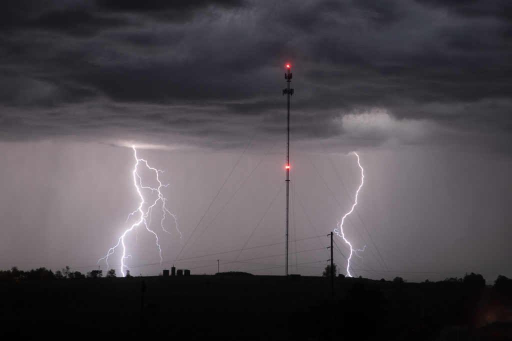
June 7th Northeast Colorado Tornado Warned Supercells
June 7th took us to the north side of the Cheyenne Ridge, playing the upslope there with moderate shear, decent moisture and instability. Several storms formed, with a couple becoming supercells and even tornado warned. It is amazing what some chasers call a tornado (landspout) when it occurred in a part of a thunderstorm that landspouts wouldn’t even form in! Stay tuned to a narrative we will publish explaining how and where a landspout would form.
These storms moved southeast into northeast Colorado and became quite intense, producing very high winds and baseball sized hail. The continued moving southeast eventually into northwest Kansas and were continuously tornado warned or severe warned. Structure was very nice as they marched into central Kansas overnight. A fun day for the tours with plenty of excitement with the storms as we moved in very close to where rotation was, but no tornadoes were confirmed. Check out the images below!