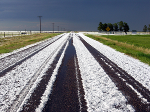
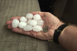
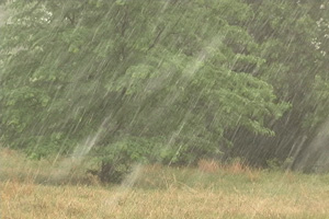
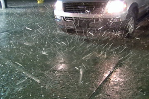
Well, another day of hailstorms for eastern Colorado. Plenty of shear was available, but little moisture plagued the area. This season has been the worst I can remember in 20 years of storm chasing. A linear storm formed east of Denver and eventually became an HP supercell. However too many storms on both flanks would not let this storm ever do anything spectacular. It did develop good rotation, nice wall clouds, TREMENDOUS hail and even a weak landspout under a forward flank cell developing.
May 30th, 2006 Western Oklahoma Supercell
This day would be another where either shear or moisture wasn’t sufficient for tornadic storms. A supercell developed south of Woodward, OK and slowly drifted south, enhancing all the shear it could get. It had pretty structure, several slowly rotating wall clouds, hail to half dollar size and intense lightning.
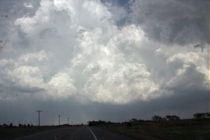
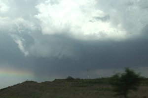
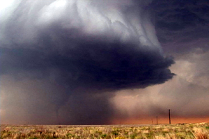
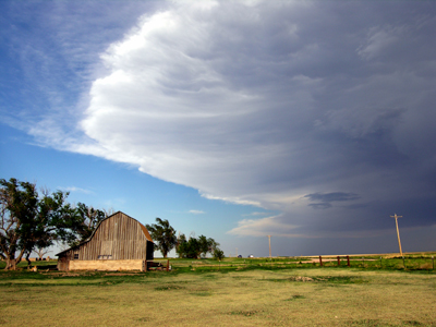
May 30, 2006 Limon, CO Supercell
May 30th was Caryn’s first solo chase this year. While I was on tour in Oklahoma, she went out and caught a beautifully structured supercell that developed on the Palmer Divide and tracked eastward along I-70.
Caryn’s summary:
Since Roger was unable to make the Palmer Divide storm, I thought it would be a good idea to keep peace in the family and go chase it myself. Errrr…..actually, I LOVE doing this stuff. There was no need for Roger to ask me twice! I was gone and out the door with a CHARGED camera in hand.
As I drew nearer the Agate exit, I kept my eye on this beautifully formed supercell south of I-70. There was very obvious rotation and my first thought was, “could it possibly turn out to be another “Limon day”? (the speedometer sure started acting like it.) Ma Nature may have robbed me of another show of 6 tornadoes but the following pictures were just as spectacular. I had a great vantage point on I-70 east all the way towards Genoa. Enjoy!

May 29, 2006 South Central Kansas Severe Storms
May 29th was a higher instability but low shear day. Several pulse storms developed in Kansas, with a couple of embedded supercells. The prettiest thing about these storms was their electrification. They also produced hail to ping pong ball size.
May 28, 2006 South Dakota Supercells
May 28 took us to northwest Nebraska and southwest South Dakota to play an advancing trough out of the Rockies. It became apparent again that moisture would be the issue as has been the case for most of the season. Storms formed along a boundary in western Nebraska and raced into South Dakota. Two supercells formed that we chased, both producing high winds and hail, but little else. We encountered intense winds with a bow echo east of Rapid City late in the evening that was quite spectacular.
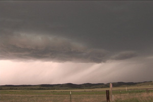
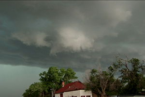
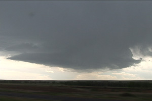
May 26, 2006 Elbert County, CO High Based Supercell
May 26 was the day between our tours. We were surprised to find a high based supercell form west of Limon, CO with a VERY nice hook on radar. This storm never did produce a tornado, but surely tried. Strong shear, but limited moisture would not allow this to get close enough to the surface to produce. It was tornado warned for 2 hours.
May 21st, 2006 Southwest Nebraska Severe Storms
May 21st took us to southwest Nebraska and far northeast Colorado for what looked to be a high based severe storm day. By late afternoon, an isolated storm developed along the CO/NE border and slowly drifted northeast. The storm never could quite get its act together, but provided for some photogenic moments. Too strong of shear and too little of moisture would not allow strong surface based instability.
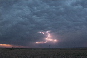
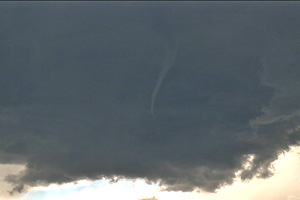
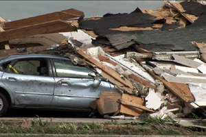
May 9th, 2006 Westminster, TX Tornadic Supercell
May 9th took us into southeast Oklahoma for what ended up being an exercise in futility. Storms tried to form but as they became organized they entrained too much dry air. We ended up heading south towards Atoka, OK as the southern Oklahoma cell hit our position with high winds, small hail and heavy rain. We took a break and ate dinner, and that decision ultimately would cost us a view of the Westminster, TX tornado in the dark. As we approached the supercell, we decided to stop the chase and not try to get in front of it as it was at its max intensity and would soon decrease and become nontornadic. Check out the photos below of the updraft structure illuminated by lightning and then the aftermath of this unfortunate killer tornado.
May 5th, 2006 Patricia, Texas Supercell and Tornado
May 5th took us to the southern Texas panhandle for what looked like a decent supercell and tornado day. Strong southwest flow aloft on top of southeast surface winds along an outflow boundary would set the stage for tornadic supercells. By late afternoon storms developed near Hobbs, New Mexico and intensified as they moved towards Seminole, Texas. The main cell entrained too much dry air and struggled until it moved off the dryline. At that point a monster updraft developed and spun like a top. A nice stovepipe shaped tornado formed back in the hail and rain northeast of the clear slot.