What a pleasant surprise this chase was!! An impressive vort max and stacked low were over northeast Colorado moving into western Kansas. By 10 am, storms were firing to the east of the vort max. I decided to blast out of Denver to get in front of this vort center and hopefully find a rotating storm. I found much more than that!!! First, a tornado occurred in Gove county, Kansas near the Castle R o ck state park. Nice small landspout. Next a rather large supercell exploded in the unstable air over Russell county, Kansas as I blasted east on I-70. Another landspout occurred near I-70 in Ellis county, Kansas. As I arrived on the now confirmed tornadic supercell, I saw a huge hail core that contained baseball sized hail. I headed east to get in front of it and southeast of the updraft. As I did a rather large stovepipe tornado formed under the rotating meso. Secondly, another smaller white tornado formed on the east side of the meso as the storm entered Lincoln county, Kansas near the town of Sylvan Grove. The storm soon went HP as I headed east towards Salina to get in front of it and watch the shelf cloud mature. But not before I was pummeled with golf ball sized hail and 70 mph winds. It was a beautiful sight!!! Please enjoy the video stills below.
August 1st, 2001 Lincoln County, CO Supercell & Tornado
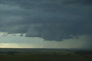
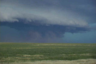
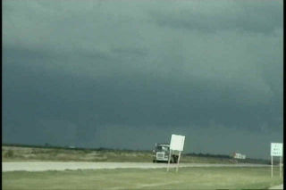
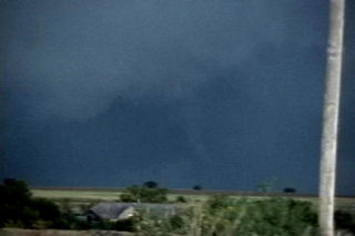
Interesting set up this day. Another boundary lay east of Denver with a nice winds shift and pseudo-dryline running from Ft Morgan to Limon. Air to the east was very moist and unstable. By mid afternoon isolated storms developed on the boundary. They started fairly high based as shown in the first couple pics below. As early evening arrived, the bases lowered as temps dropped and the dews rose. A nice supercell developed west of Limon and tracked north, then east across Lincoln county. This storm had awesome structure with a nice vault, shelf, tons of CG and even a small landspout tornado. By dark the storm weakened as the atmosphere stabilized, but not before leaving an incredible image etched in my mind.