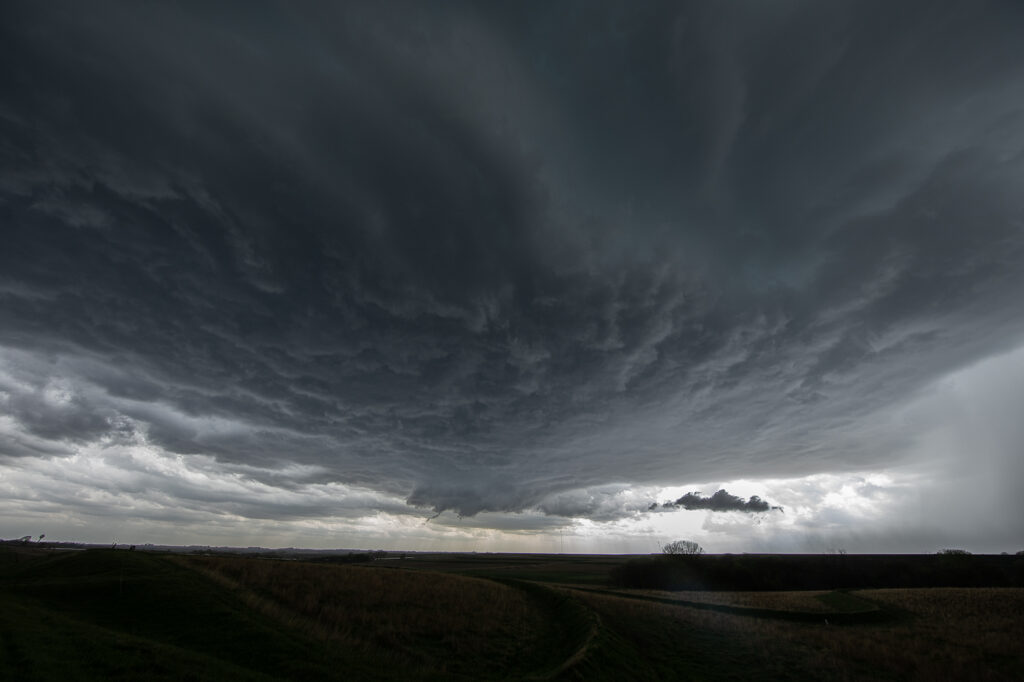
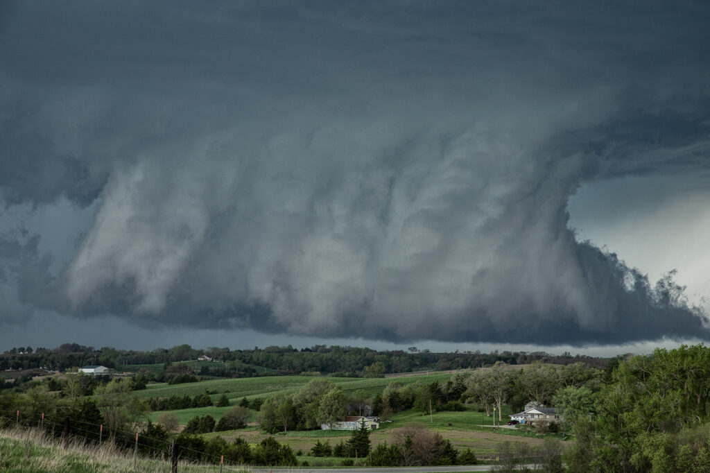
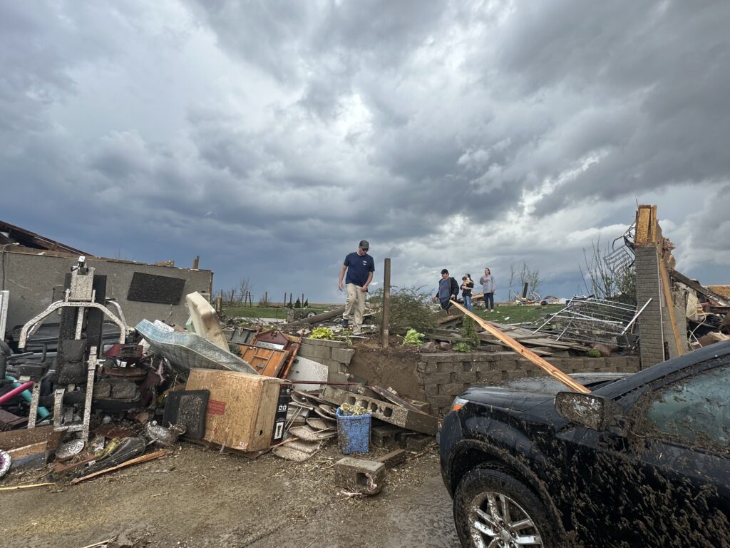
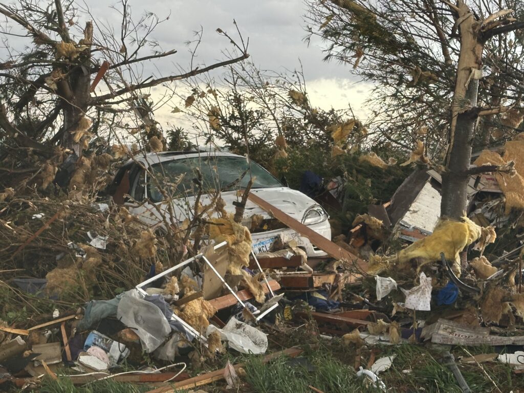
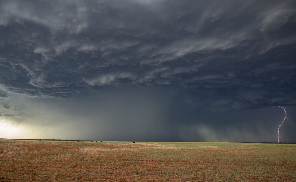
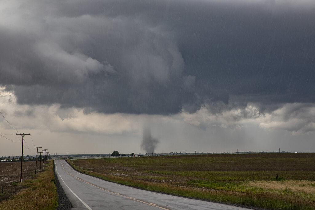
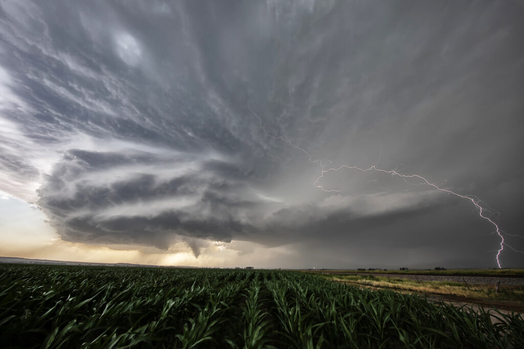
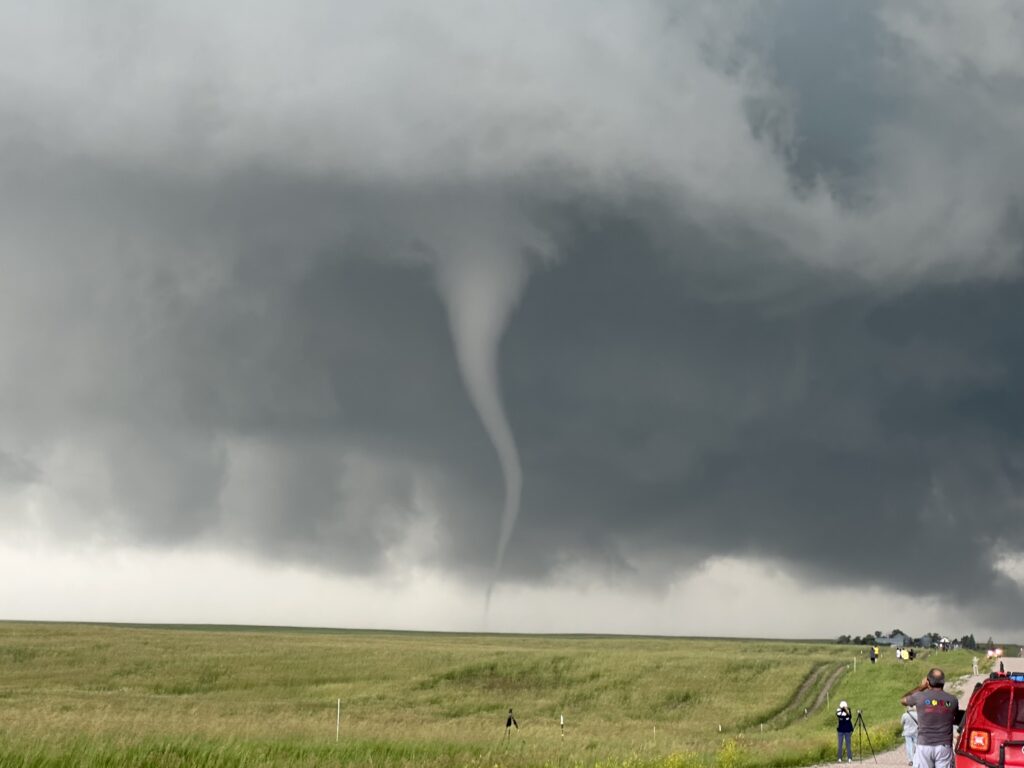
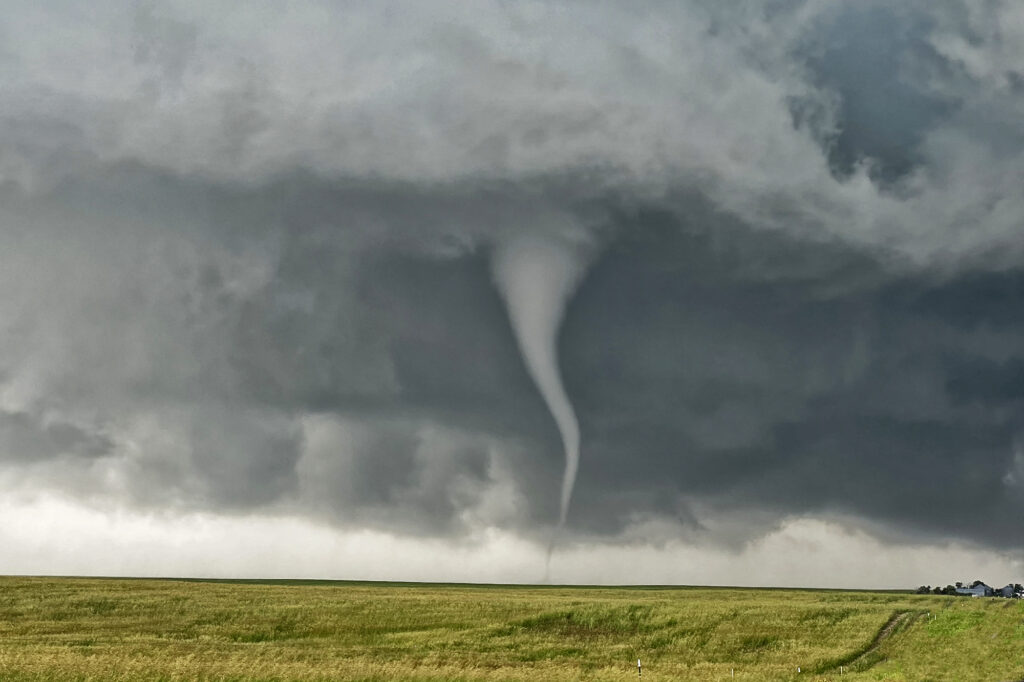
Tag Archives | storm chasing

April 15th Eva, Oklahoma Tornadoes

April 15th had potential. We weren’t sure how storm modes would end up, and the bigger question was how good of quality would low level moisture be this day. The various models were at odds with each other. We decided to target the northern Texas panhandle dryline and hope storms could form, mature and then move off the dryline into better air. We sat around the Dalhart, Texas area waiting for initiation to occur. By mid afternoon storms started to form, but due to many splits, storms never maintained for very long without having merging issues. A couple storms did intensify and one particular supercell even became tornado warned southwest of Stratford. It actually tried hard as a wall cloud formed and was steadily rotating. However, its rear flank downdraft became too strong and undercut the storm’s updraft causing it to weaken. It cycled up and down a couple times, and then near Stratford, something happened. The storm was ingesting very unstable air as inflow dramatically increased. You could see a huge dirt plume skyrocketing upward as rapid lift was occurring in the storm’s forward portion of the updraft.

A tornado warning was reissued as the storm crossed into the Oklahoma panhandle. Soon a cone shaped funnel formed and was visible for about 5 minutes before it dissipated. The structure of the supercell was top notch as a sculpted liberty bell formed and spun wildly. We raced up the highway towards Eva and sat on US 64 east of town about 5 miles. An elephant trunk shaped tornado soon formed and stabbed the ground a few times and dissipated. Quickly another larger truncated cone shaped tornado formed and stirred up dirt and debris for a minute or two and also dissipated. As the supercell crossed 64 heading towards Eva the supercell had a very strong RFD surge as a new wall cloud quickly lowered to our northwest. Soon a pretty white elephant trunk shaped tornado formed, followed by a second one just to the east of the first. These two danced around for 10 minutes, often creating multiple vortices under them and then dissipated soon afterwards. By this time darkness was approaching and the storm was weakening, so we broke off our chase and headed for home.  Great day and fortunately all tornadoes occurred in open country!

March 30th Northeast Oklahoma Tornadoes

March 30th took us to northeastern Oklahoma and southeastern Kansas on our first chase of the season for a day that promised intense storms and strong tornado potential. Things got messy pretty quickly in southeastern Kansas so we dropped south into northern Oklahoma.  First, just south of Caney, Kansas an intense supercell formed. This storm had an amazing wall cloud that was rotating rapidly. It became tornado warned, but due to too many cell mergers, it never produced. We dropped south towards Nowata, Oklahoma as a tornado warned supercell approached. This storm had incredible structures and soon dropped a truncated cone shaped tornado (rated EF1) northeast of town that skipped across the countryside for 5-10 minutes before dissipating.  The supercell continued northeast from there and dropped a second tornado (rated EF0) in open land.  This tornado actually looked stronger as darkness set up, but we were never able to get close enough to it.  Fun chase day, great results, and a long trip back to Denver.

November 16th Texas Panhandle Tornadoes

November 16th was an amazing day and night. Numerous tornadoes occurred in Texas through Kansas, with the most intense tornadoes centered on two supercells in the Texas panhandle. We had the privilege of witnessing them both. A couple hours before dark dryline storms erupted and organized near dark, producing several strong tornadoes between Groom and Pampa, Texas. We watched an elephant trunk shaped tornado, followed by a large cone, then a wedge as storms raced off at 60 mph. An incredible way to finish the year for us as well as the guests that were on this tour!


June 11th Southeast Colorado Supercell

June 11th had issues, but still produced some nice storms. Marginal moisture, but decent shear overlaid eastern Colorado. By mid afternoon storms formed along a boundary that stretched across east central and southeast Colorado.  One particular supercell tracked along the boundary from north of LaJunta to far southeast Colorado. It struggled to stay on the moist side of the boundary occasionally, but managed to be quite a prolific hail producer. Never a real threat to produce a tornado, it did however manage to produce several short lived funnels. By early evening a cluster of storms formed south of Lamar. A tail end storm became a powerful supercell and was tornado warned for a couple hours. Visually it was stunning with constant rotation under the updraft. Two tornado reports came in, however they were not validated.  As the supercell tracked into southwest Kansas, it became an outflow dominant storm and produced significant winds.

May 27th Canadian, Texas Tornado Outbreak

May 26th had incredible potential. An old outflow boundary over the northern Texas panhandle, along with a dryline extending through the Texas panhandle intersected the outflow boundary just northwest of Canadian.  High CAPE, strong shear and deep moisture would all combine to produce a violent supercell that anchored itself near the town of Canadian. By mid afternoon the storm exploded and produce several tornadoes, including a couple that were strong.  Two tornadoes came very close to hitting Canadian, but fortunately dissipated before entering town. One of the best events of this young 2015 chase season and one that will live in the memories of all tour guests for sure!

May 26th North Texas Tornadoes

Very high moisture and instability, along with an outflow boundary would provide the focus for intense supercell development over northwest Texas May 26th. Storms erupted and quickly became intense and tornado warned. Although we witnessed one tornado, several funnels and great storm structure were observed. Storms had the tendency to become high precipitation quickly and thus a couple tornadoes occurred buried deep into the rain. They were extremely hard to see and very dangerous to get close to.

May 23rd Southeast Colorado Supercell and Tornado

High CAPE, good shear and lift along a boundary would provide the focus for severe storm development on May 23rd. We arrived south of Lamar early afternoon as storms formed quickly, and became severe. An anchored supercell southwest of Lamar did everything it could to be the storm of the day (which is was). Constant new cell development on its flank resulted in the storm mode being messy. By mid afternoon, though, it managed to pull off the anchored spot and move northeast. The storm had incredible structure, HUGE hail and finally produced a weak tornado. Structure was the main thing this day and it certainly did not disappoint!

May 22nd Eastern Colorado Supercell

Day 1 for Photo Tour #1 and day 4 for the Prime Time tour took us to Colorado where highly sheared supercells formed by mid afternoon.  One storm formed west of Limon and tracked generally along I-70 eastern for several hours. The storm had super LPish structure, but was never a threat to produce tornadoes due to lower instability. Nonetheless, it was a pretty sight to watch and was extremely photogenic.  All in all, a successful chase day for everyone!

May 16th Elmer, Oklahoma Violent Tornado

An amazing day was to unfold across southern Oklahoma on May 16th.  A dryline and outflow boundary intersection would become the favored point for intense supercell storm development by late afternoon. We cut east to get in front of the Elmer, OK storm and watched as the updraft started spinning wildly. Within a few minutes a very large tornado formed just southwest of town. This tornado would grow to enormous proportions and skirt the south side of town on its way towards Snyder. We were on the north side of the tornado as it moved northeast and had an amazing view! Soon, though the approaching tornado would require us to move eastward along its path and it continued to give us a fanastic view!

After the storm became messy, we dropped south to Walters, Oklahoma where a beautiful supercell, highly striated, would produce a cone tornado. It was a day nobody on tour will ever forget! To see and hear the raw power of a violent tornado is something to remember forever!