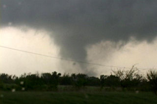
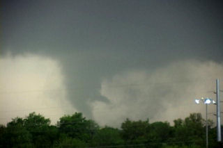
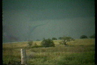
June 9 was to be one of those unforgettable days. Strong shortwave energy approaching from the west was to interact with a warm front boundary in northern Nebraska where rapidly increasing moisture would help provide the fuel needed to spark severe thunderstorms. By late afternoon a thunderstorm developed near Springview northwest of O’Neill. This storm went on to produce at least 3 confirmed tornadoes over the next several hours. Two of these tornadoes were photogenic with the final one north of O’Neill being a large dusty multivortex tornado. Pics of these tornadoes are shown below in the order that they occurred. Enjoy!
May 4th, 2003 Pierce City, MO Long-tracked Tornado
Unbelievable day in the southeastern plains today! We began the day in OKC, determined to consider playing the tail end of this system. My concern (in addition to storm motion) was that the best show might occur in a narrow and early window over SC-E Nebraska (16-19Z) and then it would be over. Upon waking and looking at the data, it became apparent that the setup was indeed outbreak-like and that therefore one could likely pick about any storm and expect to see large tornadoes. Analysis soon suggested that the cap would break explosively in the HCRs ( horizontal convective rolls – bands of congested cumulus from which the most important storms of the day often develop; these bands are generally oriented along the low-level shear vector ) embedded within the highly unstable, strongly sheared warm sector. Stopping in El Dorado for fuel we watched as our surface winds slowly veered and our dewpoint spiked lower. Surface analysis revealed an intense low-level dry punch surging inexorably eastward towards SE KS and NE OK. I couldn’t believe it when I downloaded the SPC STOR and saw the 8-11 values blanketing the entire risk area from SE NE to N TX.
We decided on the spot to target SE KS, first intercepting storms on the northern portion of the E KS theta-e tongue and then dropping southward on different storms. We drove east on Hwy 54 to Iola and then north on 169 to Welda, KS where we sat for close to an hour watching convective towers get shredded to bits. Radar downloads revealed an intensifying cell moving NE towards the area south of CNU; rather than jumping on that as soon as we saw the first reflectivity core in NE Osage County, Oklahoma we sat watching convective towers closer to us. However, as the cell slowly matured and moved into Chautauqa Co. (see the radar downloaded via cell phone at the time, shown in Fig. 6 below), we could no longer sit still as we became convinced that this storm would become a prolific tornado producer. Driving south and then navigating around the NE side of CNU, we dropped SE in a desperate attempt to get ahead of this incredible storm (radar shot at the time, Fig. 7). As we passed the junction of Hwy 57/59 driving south on Hwy 59, we drooled at the spectacle of the rock hard convective bomb to our ESE. Following the western edge of the updraft down to cloud base, we immediately spotted a classic stovepipe tornado spewing debris about 7-8 miles to our E, somewhere near or just east of the Neosho wildlife area. Cursing at our failure to jump right on this storm as quickly as we noticed it on radar, we drove east on 160 out of Parsons, quickly taking up the rear of a very long and very sloooow moving caravan of storm chasers. We busted north and east on Hwy 126 intending to eventually intercept the classic tornadic supercell east of Girard, KS at or near the MO border. I gasped at the radar depiction of the storm’s hook overtaking Girard and wondered what kind of devastation was in store for towns east of this storm.
We were making great time and might have actually outflanked the storm as planned. However, fresh radar downloads revealed a very good looking tail end storm in Nowata Co. OK and we became convinced that this storm would eventually go on to produce significant tornadoes provided the dreaded 80-mph left mover to its SSE didn’t interfere too badly (this bit of bad luck killed what might have been a strong tornadic storm the day before near Childress, TX). On the way south to intercept the OK storm, we quickly detoured to check out the updraft base of another supercell moving NE through Labette Co., KS and quickly spotted a truncated cone tornado emanating from cloud base to our distant west. The storm started to look a bit more organized shortly afterwards and we pressed south, worrying that the Labette Co. storm would be interfered with by the tail end Charlie and would too seriously detract us from intercepting the southern storm. Driving through scattered golf ball -sized hail in the FF core, we observed the updraft (completely separated from FF core) and immediately noticed a fat, nubby funnel cloud just NE of Fairland, OK (we later learned that this was a weak tornado but couldn’t see the ground-based circulation for all of the trees and hills). Soon thereafter, the storm became rather disorganized as it merged with the left mover. Nonetheless, we persisted chasing this storm noting that inflow was still quite strong and moist southeast of the RF gust front . The storm began to intensify and take on scary HP/classic hybrid characteristics east of Neosho (which was devastated by a tornado on 4/24/75). Racing east on Hwy 86, we attempted to get to Hwy 60 north of Newtonia but the storm’s horrendous looking rear-flank core soon overtook the road before we got there and, fearing very large hail and powerful winds, we turned around and continued E and SE on Hwy 86, eventually turning north on Hwy 37 at the town of Purdy.
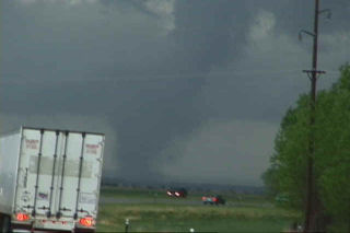
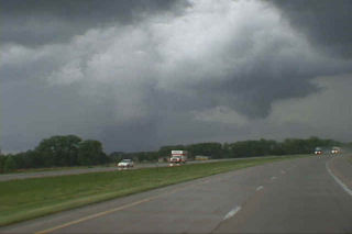
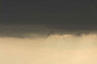
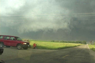
All this time, we were experiencing the storm’s ambient inflow which was 76/66 on 1725 winds. A new radar download revealed that this storm had retained classic supercell character with a vengeance and we wasted no time at all getting north to Monett , MO. The clefted -out barrel-shaped meso of an incredible beefy tornadic storm revealed itself to us soon after turning north out of Purdy and, 1 mile south of Monett , we observed a very large strong/violent tornado just northeast of town. We turned east on 60 and for the next 35-40 minutes experienced one of the most thrilling and fascinating tornadic experiences I’ve had. We watched in amazement as this fat, inky black-blue tornado rampaged across the countryside between Monett and Verona, spewing huge plumes of dirt/debris skyward. The tornado morphed into a fabulously fluid and dynamic multiple vortex tornado with evolutions that are best viewed on video rather than described. We got closer and closer to this high-contrast, long-lived tornado, watching as it lofted debris into cloud base and fearing for all in its path. I relayed reports to people with access to NWS numbers the best I could. I fear the tornado hit the north side of Aurora, MO. At times we got as close as 2/3 of a mile from the tornado as we drove northeast on Hwy 60 and then east on farm road 2200 south of Marionville and then Hwy 173 east of town. We got farther south of the tornado than we would have liked by this time (after being so close for so very long) but we got view of it again beneath the center of the incredible ground-dragging, clefted mesocyclone SW of Springfield: now it was an intense looking high-contrast stovepipe tornado with a fan-shaped debris cloud near Battlefield, MO. We watched as the tornado endured a classic rope-out on the west side of SGF, sparing the fortunate citizens of that city a bad tornado disaster.
April 27th, 2002 Crete, Nebraska Tornado
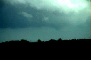
This was an interesting day to chase. The atmosphere over my target area was cloudy and cool, with temps in the low 50s and dewpoints near 50. A moderate risk was issued by SPC, and if skies could just clear enough to destabilize the atmosphere, then there was a good chance of significant tornadoes. I left Denver driving through the rain and snow and arrived near Alma, Nebraska by 1 PM. Skies were clearing as the dry slot had pushed northward. A rope cloud had formed and towers were trying oh so hard to establish themselves with little luck. Finally enough heating had occurred to warm temps into the low 60s with dewpoints near 60. A couple cbs became rooted in the boundary layer and quickly exhibited mini-supercell characteristics. Shortly after 3 PM a rapidly rotating cb developed southwest of Crete, Nebraska. This cell raced northward at 50 mph and produced a tornado that stayed on the ground for 4.5 miles just west of Crete. Unfortunately, I did not get my camcorder up and running and focused in time to catch the mature part of the tornado. Photos are below. A couple of the photos have been enhanced to see the tornado in its latter stages.
September 22st, 2001 Clay County, NE Tornadic Supercell
I had no idea was the results of Sept 22 chase would be, but I certainly did not expect what I got. My son and I left early morning for our target of York, Nebraska. We arrived by mid afternoon to a cirrus shield and stratus left over from morning convection. However, an outflow boundary was in place from near Grand Island southeast towards Concordia, Kansas. We sat and sat with nothing happening. Then finally around 6 PM (6pm magic !!), things started to change. Towers were exploding not far from Clay Center and soon our first storm developed. It did not look that great, but was only a harbinger of things to come. Another cell went up and produced several small funnels. Then a larger funnel formed and eventually touched down near Saronville, Nebraska. It later dissipated only to be replaced by another, yet larger tornado at dark. The second tornado was eventually rated F3. We found a prominent damage path and a couple of farmsteads destroyed. This storm had the classic mothership appearance and was one of the prettiest supercells of the year.
May 17th, 2000 Brady, Nebraska Supercell & Tornadoes
May 17 was another one of the unforgettable days as a tour guide for Silver Lining Tours. Most of Nebraska was under a moderate risk and the set up was promising for tornadic supercells. A strong low was parked over far southwest Nebraska with a warm front across the I 80 area. A dryline was pushing east and north which put the North Platte area in line for some great action. High based storms fired along the dryline in northwest Kansas by early afternoon.
We waited near Lexington for the first cell to fire northeast of the dryline, and it did. This cell raced northwestward over Frontier county and produced our first tornado of the day (see photos below from Farnam). An LP supercell was just east of the first storm and really starting to look impressive as it tracked just east of the first storm. This was the storm that would produce the damaging Brady tornado. We quickly headed north to intercept the Brady storm which was now a gorgeous barber pole supercell. As we headed west on I 80 near Maxwell, a large tornado was visible just south of the Platte River. Pics of this memorable supercell, tornado and damage are below.