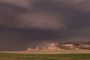
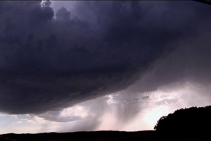
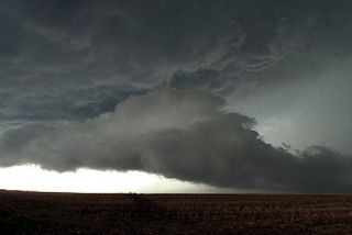
June 11 was the first day of tour 6. We debated on whether to stay in Colorado or head north. Surface flow and moisture was a bit better north into southwest Nebraska. And after a call from Dave Gold, north we headed. We arrived on the scene near the Scottsbluff National Monument to see a beautifully striated rotating supercell sucking dirt off the top of the monument. This storm did all it could to produce a tornado, even with a strongly rotating lowering on the northeast side of the storm. But it never could quite focus long enough to produce. However the structure was incredible!!!
June 9th, 2006 Nebraska Supercells
June 9 would be a day where several supercells formed along an outflow boundary/cold front over central and northern Nebraska. We intercepted 3 nice storms there. The first storm was a classic with large hail and high wind. The second was another classic that was tornado warned and had beautiful structure, and the thirds was a beautiful LP. Shear was great, instability good, but moisture was a bit lacking.
May 21st, 2006 Southwest Nebraska Severe Storms
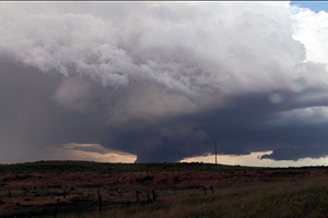
May 21st took us to southwest Nebraska and far northeast Colorado for what looked to be a high based severe storm day. By late afternoon, an isolated storm developed along the CO/NE border and slowly drifted northeast. The storm never could quite get its act together, but provided for some photogenic moments. Too strong of shear and too little of moisture would not allow strong surface based instability.
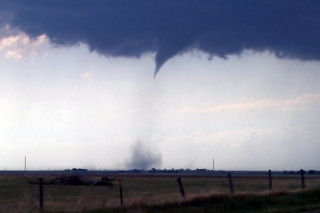
April 15th, 2006 Otoe County, NE Tornado
April 15th brought me out to chase. Models were conflicting on the amount of moisture that would be available, but one thing for sure was that all other ingredients would be in place for rotating supercells. By mid afternoon, dewpoints had risen into the upper 50s to near 60F and that was enough to produce strong updrafts which allowed the shear to take over and produce tornadoes. I caught one such tornadic supercell as it entered Otoe county, Nebraska, about 50 miles south of Omaha.
May 17th, 2005 North Platte, Nebraska Supercell Spin-ups
We spent the night in North Platte on the 16th, thus allowing us to stay in the area for the 17th. Everything pointed to strong linear forcing and a quick evolution into a squall line for any storm that formed. By mid afternoon, a triple point became very clear southwest of North Platte. We were able to sit and watch a supercell develop on the triple point. What a treat!!! This storm was fairly high based, but produced several spins ups, a couple tornadic and many on the gust front.
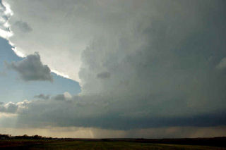
May 10th & 11th, 2005 Supercells & Tornado
An interesting period for May 10 and 11. I captured an incredible mothersip supercell May 10 near Grand Island . This storm formed on the triple point and became one of the prettiest supercells, structure wise, that I had ever seen. It almost immediately started rotating and became severe quickly after it formed. There were many reports of tornadoes with this storm, none of which I believe are true. It was fairly high based its entire life.
On May 11 we left Kearney mid morning headed south towards Stockton , Kansas . When we arrived it was 81/68 with a nice southeast wind early afternoon. We watched as soft towers would go up and get sheared over. We ended up chasing the cell that was tornado warned northwest of Stockton . These cells were high based, and not very organized. As they crossed front, they became even more elevated and did not much of anything.
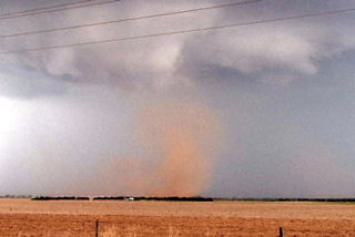
Mid afternoon we blew of this junk and headed west to the triple point as cell exploded there. We arrived near Benkelman and came over a hill to catch a glimpse of a weak skinny tornado west of town. The storms looked linear somewhat with a shelf cloud racing northeast. Updrafts were visible behind the shelf. Then something weird happened. My temp and dewpoint went from 63/59 to 71/64 in a matter of 1 minute. All of a sudden an updraft base starting rapid cascading motion, then rapid anticyclonic twisting and turning. Then a loud waterfall sound formed and a few seconds later a tapered cone funnel formed almost overhead. As quick as all the happened, less than a minute, a debris cloud formed in a field just to the southwest of the van. RFD hit the van on the NORTH side of the tornado, which we determined WAS anticyclonic!
We blasted north away of this northeast moving tornado as condensation developed to the ground. Our view out the west side of the van was one of condensation lifting with multiple vortices twisting and turning as debris, old corn stalks and tumbleweeds went flying up and rapidly rotating around the vortex! This tornado was no more than 100 yards from us and closing. We drove at a fast pace to get away from this tornado and managed to get a quarter mile away and we stopped. It immediately dissipated as the funnel rapidly vanished. This entire sequence happened in 3 minutes!
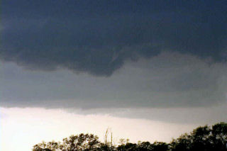
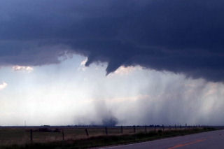
April 19th, 2005 Logan County Supercell & Tornado(s)?
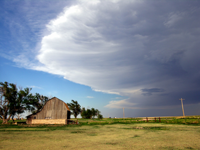
April 19 was an interesting set up. A large closed low over the inter-mountain west would meander without moving much eastward this day. A surface low would develop over northeast Colorado with a boundary extending into Nebraska. This boundary would be to focus for severe thunderstorm development. Several storm first formed north into Nebraska and went severe. I decided to play the tail end storm which ended up being the prettiest storm of the day. Explosive convection developed north of Sterling mid afternoon as a substantial LP supercell formed. This storm produced at least one brief tornado, if not two!
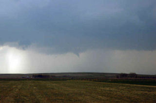
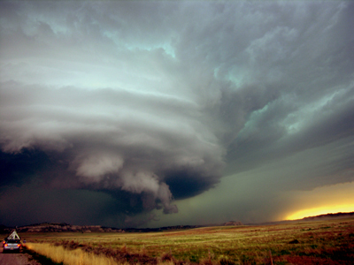
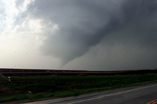
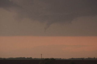
June 10th, 2004 Chappell, Nebraska Tornadic Supercell
June 10 was to be a day nobody would forget. We started in North Platte and analyzed data till early afternoon when a cell blew up west of Julesburg, Colorado on the dry line. I rallied the gang westward and arrived west of Big Spring on US30 just in time to watch the show start. This supercell developed into a beautiful classic with nice wall cloud, clear slot, FF core and an incredible tornado that lasted 28 minutes! This tornado morphed from a small nub funnel with debris cloud, into a full fledged strong cone tornado. The structure of this beast was a sight to behold!!!
May 22nd, 2004 Nebraska Tornadofest
May 22 took me to Nebraska. All things were coming together for quite a severe weather episode. A strong dynamic low and associated trough were coming out of Colorado headed for southern Nebraska. All severe weather indices were pointing to the area southeast of McCook, eastward towards Fairbury. Enough shear, instability, moisture and lift were present for strong tornadic supercells, and the atmosphere did not disappoint. By early afternoon, severe thunderstorms erupted in Colorado and spread into southwest Nebraska. We blasted westbound out of Hastings towards the tail end supercell southeast of McCook. We arrived in Beaver City in time for the show of the day. A quick tornado developed as the storm ingested deeper moisture, however this would be just the beginning.
Soon, a strong tornado developed just south of town and stayed on the ground for about 15 minutes. This was a beautiful elephant trunk/stovepipe that did little damage. A second tornado formed after an occlusion near the town of Orleans. This tornado just missed the north side of town. We are parallel with the tornado its entire life cycle. Just east of town I got out of the van and video taped as the tornado churned about 200 yards north of the road. It hit s building and filled the air with debris. I jumped back in the car and we drove east as it dissipated. In the meantime another tornadic storm (near Hallam, NE) formed. As we tried in vain to catch it a another storm formed near Republic, Kansas. This storm would produce 3 tornadoes, one of which was fairly strong. The updraft structure was breathtaking!!!! Finally at dark the last tornado formed with this storm as we blew it off to get ready for Illinois the next day.
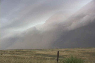
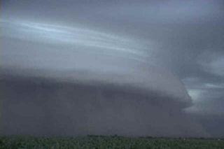
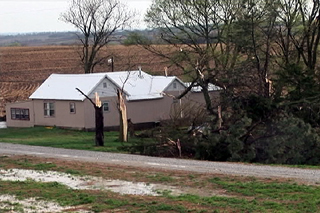
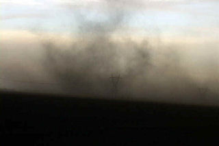
July 7th, 2003 Ogallala, Nebraska Windstorm
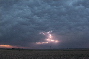
This day would prove to be a rather interesting day. Several storms developed in eastern Colorado and merged into on very large bow echo as it approached Nebraska. Wind gusted to over 100 mph and caused considerable wind damage. Trees were down, as well as power outages and minor structural damage. One thing for sure was that the shelf cloud that formed with this system was quite impressive.