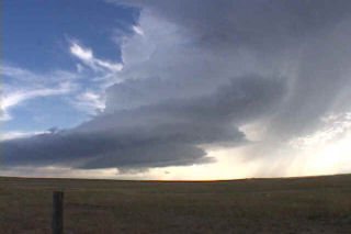
Montana was the place to be on June 8. A strong short wave pushing across the state would spawn supercell thunderstorms off the northern Big Horn mountains. We intercepted 3 supercells. The first was a dying beast that dumped hail baseball sized over the area. The second developed a well defined wall cloud and I though for a few moments there could be tornadogenesis any moment. The third supercell was the storm of the day. It developed just east of the first two on the outflow boundary. It became a striated monster, with a well developed wall cloud (above). A clear slot formed and strong RFD winds cut into the back of the storm. We came very close to a tornado as the wall cloud, now rapidly rotating passed just north of Lame Deer. Finally it became an HP storm and eventually gusted out. Thanks to Caryn for her superb driving skills keeping us ahead of this beast on dirt and gravel roads!
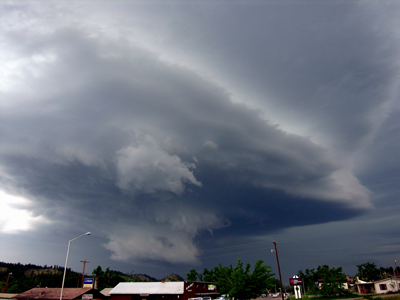
June 6th, 2005 Ekalaka, Montana Tornadic Supercell
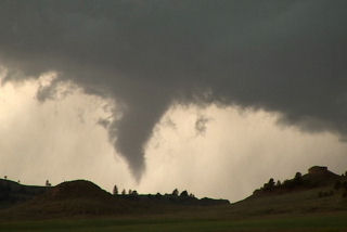
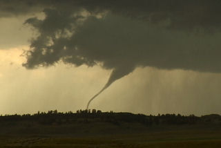
What an interesting day this turned out to be. We started in Gillette, WY, blasted to Ekalaka, MT and sat north of town and waited, and waited and waited 🙂 Finally a high based little LP updraft developed, as usual, and was severe warned. The interesting thing with this is it was feeding on 72/56 air. It moved north and weakened. Then another storm RAPIDLY developed and intensified, southwest of town. This storm became a BEAUTIFUL striated stack of plates supercell, and quickly developed a nice wall cloud. Condensation streamed in from the northeast and soon a lowering was observed almost to the ground. Rotation developed and a funnel formed AWAY from the wall cloud. It extended a third of the way to the ground and dissipated.
Then a second funnel formed without being connected to the base, then developed a debris cloud and connected to the base!! Bizarre tornado! It stayed on the ground maybe 2 minutes and dissipated too. A third funnel formed and became a gorgeous elephant trunk tornado with INTENSE rotation and cascading motion in the cloud base. This also lasted 2-3 minutes. It also was rotating around the outer edge of the meso. A fourth funnel formed, a truncated cone, and became tornadic too with a debris cloud. This one lasted at least 5-6 minutes before dissipating. Eventually the lowering wrapped in rain, and then the rain curtains parted revealing a long slender funnel halfway to the ground!! What a surprise! I was NOT expecting this type of a supercell today at all!!
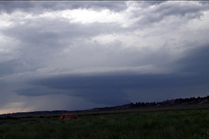
August 6th, 2002 Lewistown, MT Awesome LP Supercell
August 6th was a simple an fun chase day. For the second day in a row significant severe weather was a sure bet. I spent the night in Lewistown, MT and didn’t have to leave. By lat afternoon an HP supercell developed just east of town. This storm produced high winds and large hail. Another, by far prettier supercell developed just west of the first. It became my favorite LP supercell of the year as it went on to survive for 6 hours and produce softball sized hail.