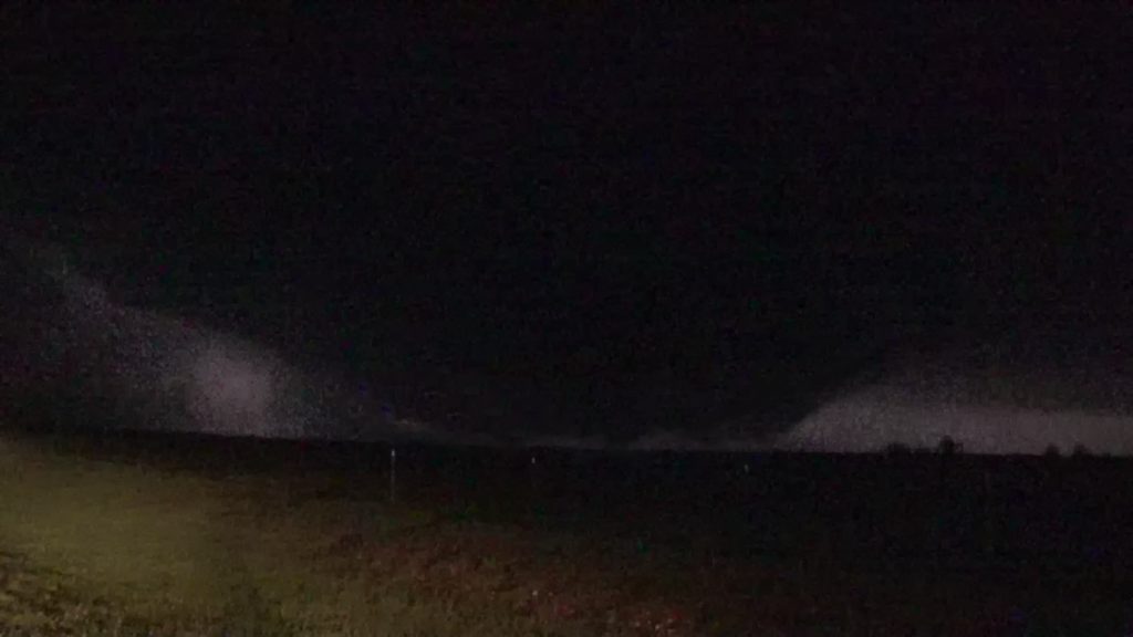
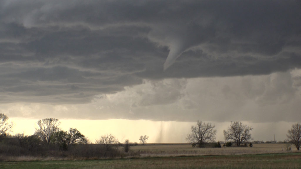
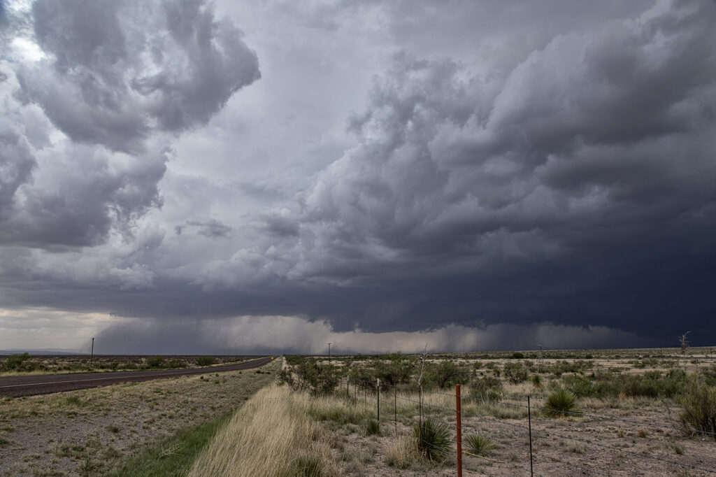
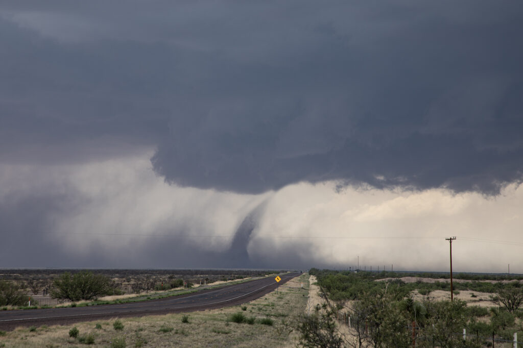
June 10th took us deep into southwest Texas in the Davis Mountains. One of the prettiest places in the state. Northwest flow aloft and southeast surface winds provided decent shear, and dewpoints in the low to mid 60s, fueled 3000 CAPE. The ingredients were there for severe storms and supercells. What we didn’t expect was to see a tornado, albeit a weak one! Mid afternoon we were near Alpine watching storms come off Mt Livermore and move southeast. The struggled mightily, so we left there and headed west to the surface triple point just west of Marfa. A supercell had formed and was anchored so we knew it would be spinning. As we arrived, a big blocky wall cloud was present with intense cgs raining down to our west. Soon a clear slot formed and you coudl see the RFD wrapping around the mesocyclone. Within another 15 minutes a dirt column formed and a small funnel was visible at cloud base. This persisted for about 8 minutes. What a surprise! The storm became outflow dominant due to weak flow at anvil level, and soon a tornado warning was issued (for the one we saw, but reported by another storm chaser!). We stayed with it for a bit longer until the outflow surged out from the supercell and it collapsed. A nice end to a day that we though would produce a decent storm. Enjoy the pics!
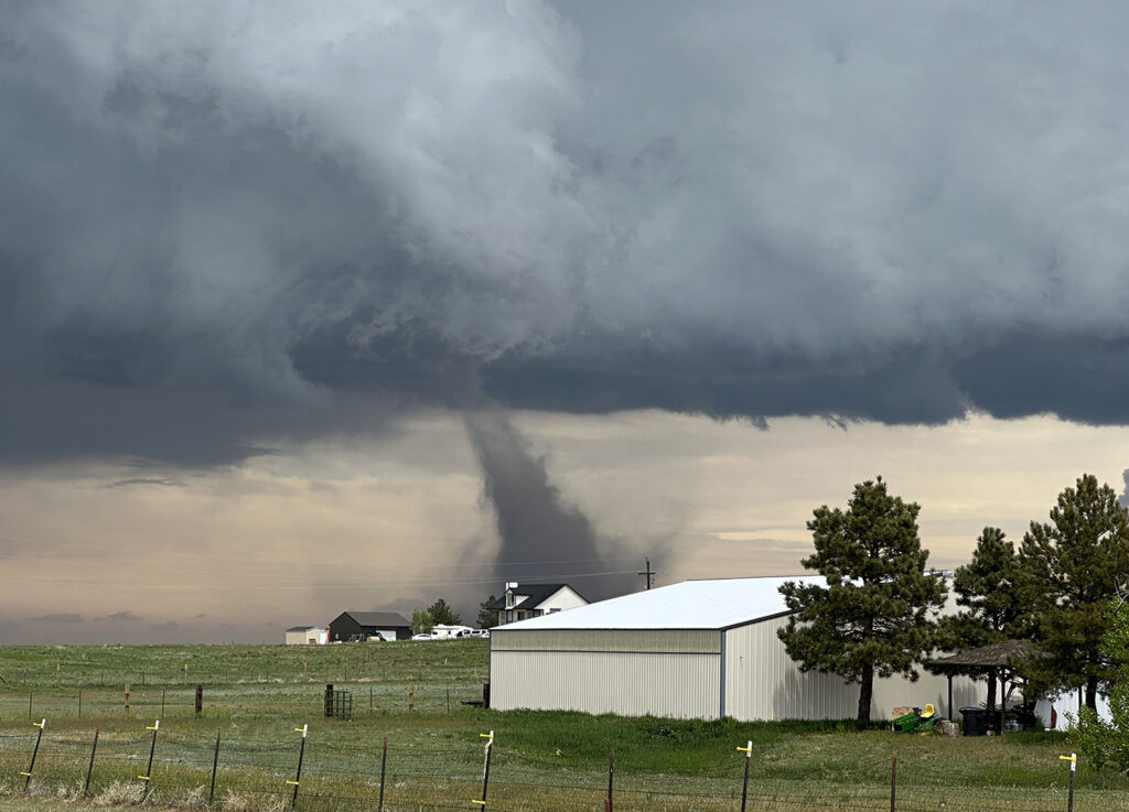
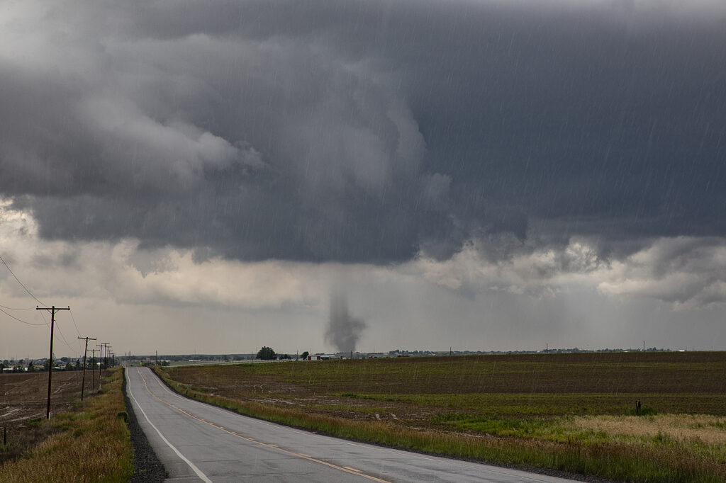
May 18th Bennett, CO Tornadoes Event
It is not often that the hunter becomes the hunted. However, of May 18th, that is exactly what happened at our home near Bennett, CO. A supercell thunderstorm developed southwest of our house. It produced it’s first of 4 tornadoes near Southlands (Aurora). The second tornado formed southwest of Box Elder Creek Ranches where we live. As it traveled northeast, Caryn Hill saw it and took action. She alerted locals in our miniranch neighborhood and then took off to chase it. It entered our residential area causing EF1 damage. It destroyed barns, garages, other structures and unfortunately killed farm animals. The second tornado dissipated northeast of our house as a third and then fourth tornado formed. These caused extensive damage near Bennett and were both rated EF2. Caryn stayed with the supercell and tornadoes as they moved north of Bennett and eventually roped out. After returning to Box Elder Creek Ranches, she and other neighbors jumped in to help those with damage. Our place was mostly spared, with just some downed trees, and a roof leak which we aren’t sure exactly how it happened. I guess with 80-100 mph winds hitting around the tornado anything is possible! Here’s some pics and also a Youtube video of the event.
May 14th Hershey, Nebraska Tornadoes
Wasn’t expecting a lot on May 14th. Moisture was lacking, but shear and lift were good. We chased a high based supercell north of McCook, NE and stayed with it as it moved north. It eventually dissipated as a wind shift boundary west of North Platte generated numerous severe thunderstorms. We approached North Platte as a landspout tornado formed south of Hershey. It persisted for several minutes before roping out. Soon a second tornado formed and became quite pretty! It lasted over 10 minutes before diminishing. Not long after that another tornado formed. It morphed into a slender elephant trunk shaped tornado and also lasted over 10 minutes. Finally we decided to head west on I-80 to the storm, now a formidable supercell. Decent structure and huge hail greeted us north of Hershey, and we decided to head back east as it rapidly weakened when it came off the boundary. A lot of fun today. Great lightning, nice tornadoes and good storm structure! Enjoy the photos!
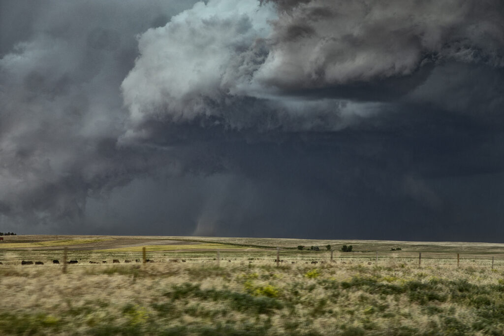
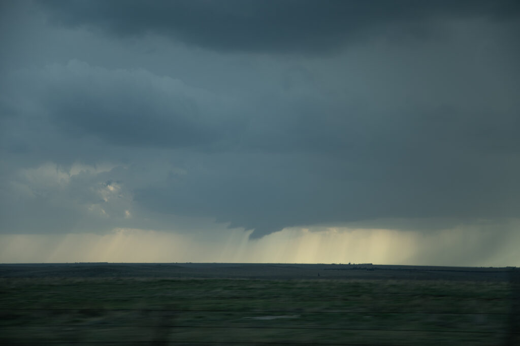
June 20th Hawk Springs, Wyoming Tornado
June 20th took us to the high plains to play the Chugwater Convergence Zone. Moisture was less than optimal, but shear and lift along the boundary would be sufficient to generate severe thunderstorms, including a couple of supercells. We arrived west of Scottsbluff, NE to find a storm already mature and severe. As it moved east towards Hawk Spring, a slender tornado formed and was on the ground for several minutes. We turned east of town on a dirt road only to get blasted by 80mph plus winds from the rear flank of the supercell. By the time we could work southeast and then north to get back in front of it, the storm was now a line of severe thunderstorms. Soon, as they became outflow dominant, we left them and called it a night. Fun day and a surprise tornado is always welcomed! Enjoy the pics!

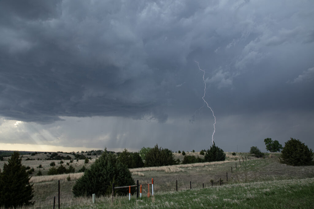
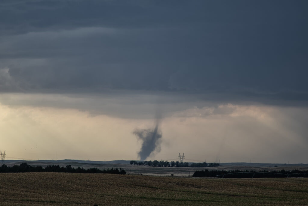
June 18th Kalvesta, Kansas Tornadoes
June 18th featured a stationary boundary draped across southwest Kansas. Dewpoints in the 60s and temps in the 90s, as well as the wind shift along the boundary would set the stage for not only landspout tornadoes, but also supercells forming and anchoring along the boundary. We intercepted one such storm that produced a landspout in its formation stage, followed by a legitimate supercell with a strong velocity couplet that lead to a 10 minute long tornado. The structure became quite nice and the storm was incredibly electrified! At one point a lightning strike produced a fire on wheat fields that were ready to be harvested. A very unfortunate incident for the local farmers. We then dropped south to just north of Cimarron where we encountered another strongly developing mesocyclone that produced a tapered cone funnel with a brief circulation. Many thanks to our guest, Leann Yamanaka for the pics of that funnel/circulation from beside the van! Finally, south of Liberal, Kansas a very photogenic supercell emerged from a cluster of cells at sunset and produced absolutely gorgeous mammatus clouds. Enjoy the pics!
Check out this cool video from that day!
https://youtu.be/mef65EQuBMs


May 1st North Central Kansas Tornadic Supercell
May 1st showed plenty of opportunity for severe storms, however the best tornado threat was in 2 different area, the Texas panhandle, and north central Kansas. Since we couldn’t make it to Texas in time, we chose the northern target. Moisture was limited and it was going to be close to get moisture this far north before storm initiation occurred. Storms formed rapidly later afternoon and intensified during the evening. 2 supercells emerged with the tail end storm eventually becoming the dominant cell. As it moved across north central Kansas in the evening it continued to intensify. It stayed along and just on the cool side of an old outflow boundary south of Interstate 70. Inflow was quite strong, and lighting frequent. At sunset, it ramped up in intensity and produced a couple of brief tornadoes under the front edge of the updraft as RFD surged around from the south side. Both tornadoes were weak and lasted only 2-4 minutes each. We eventually let is go as it continued to move north of the boundary since we had to be in Texas the next day. A fun day, with decent results, but had the supercell attached to the boundary it could have been quite a bit more tornadic. Enjoy the photos!

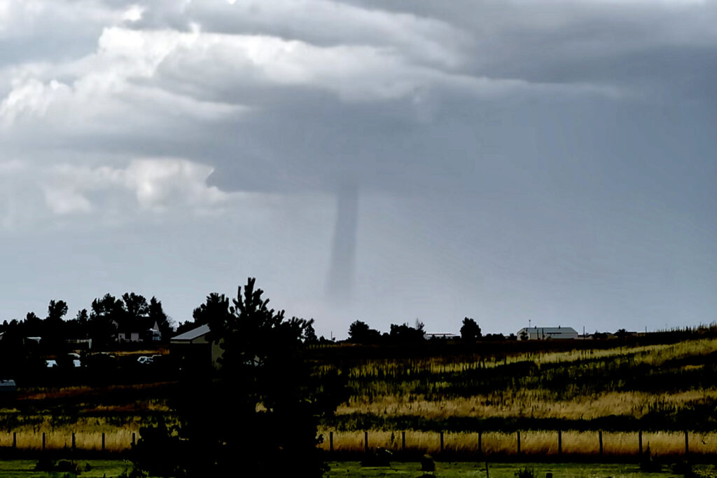
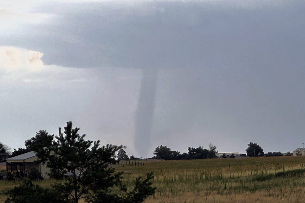
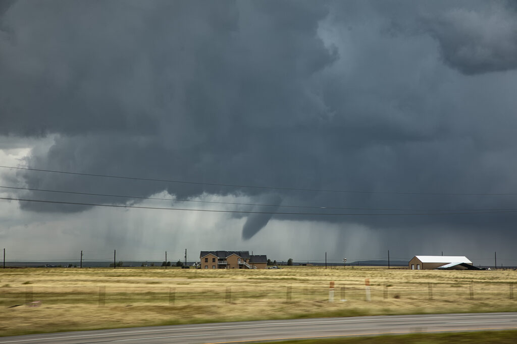
July 29th Adams County, Colorado Tornado
A DCVZ (Denver Convergence Vorticity Zone) boundary set up with good southeast winds along and north of the Palmer Divide in east central Colorado. As surface winds wrapped around the north side of the Palmer Divide, a Denver cyclone formed. By mid afternoon cumulus towers formed along the boundary. One such tower developed into an intense thunderstorm and spawned a landspout tornado north of our house. Caryn, doing a local chase, intercepted the storm as a mature landspout was visible from many miles away. It stayed on the ground for several minutes before lifting. The tower cam at Denver International Airport even picked it up clearly!
July 6th Aurora/Watkins, CO Tornadoes
It’s always fun when severe weather keeps you in your own backyard! Such was the case on July 6th! A boundary stretched across the Aurora/Watkins areas and by mid afternoon, storms rapidly developed. Soon a tornado formed south of I-70 touching down for a few minutes. About 30 minutes later, a landspout tornado formed along the boundary just northeast of Watkins persisting for several minutes. We stayed with the storms to see if any other tornadoes would form along the boundary, but as if often the case, wind fields were disrupted by ongoing storms, thus lessoning the chance another tornado would occur. Great backyard chase!
May 10th Akron, CO Tornado and Supercell
May 10th had great potential in eastern Colorado. Upslope flow, and approaching short wave, good moisture and moderate instability would set the stage for intense storm formation by early afternoon. Initial storms would cluster and produce copious amounts of hail around the Denver metro area and just east. A boundary draped along I-76 eastward towards Wray would be the focus for a few supercells that would produce a couple tornadoes. We were heading towards Akron when we encountered a HUGE line of chasers stopped at construction red lights. This delayed us almost 30 minutes! We ended up watching a tornado from the construction back up and had no way to get east due to flooded and extremely muddied dirt roads. A frustrating day, but at least we managed to catch a tornado!
April 29th Central and Southern Kansas Tornadoes
A big day was in store for Kansas. Supercells with tornadoes were possible as a combination of wind shear, moisture and instability were present with an approaching trough. By mid afternoon the dryline sharpened and soon cumulus towers formed. A cluster of storms had formed northeast of McPherson and the tail end storm started spinning. One small tornado formed as the cell moved north towards the warm front. As it approached it, other storms started forming on an advancing cold front and also became severe. We decided to leave the first storm as storm mergers made things too messy. As we blasted south towards Wichita, a landspout tornado formed underneath an updraft in the line and stayed on the ground for 12 minutes. When is dissipated, when then turned our attention to a supercell near Wichita. It had just spawned the Andover tornado and continued to cycle and become tornadic again near El Dorado. We blasted down to town, now in the dark and headed east towards the supercell’s updraft base. Quickly a tapered cone tornado formed and became visible through power flashes and lighting. It crossed the road in front of us and dissipated. Another one formed within a couple minutes and stabbed down to the ground and lifted. We continued to drift east with the storm and turned north at Rosalia. As we did a massive bowl formed and dropped to the ground! A wedge type tornado formed with multiple vortices. We got blasted with RFD winds wrapping around the tornado and had to vacate the area. As we continued east the tornado lifted as a line of storms merged with it ending the tornado threat. A crazy day with 5 tornadoes! Enjoy the pics!