June 11, 2026 was a big day forecast in Illinois and it certainly lived up to its billing! Monster CAPE, shear and moisture were in place. By mid afternoon, an outflow boundary was the spot where initiation occurred. It didn’t take long for a supercell to form west of McComb and become tornado warned. As the storm moved closer to town, it produced a tapered elephant trunk tornado that was on the ground for a couple minutes before being interfered with by a supercell to its south. We left the first storm and headed south to catch the next supercell. As we cleared the core of the first storm, a big mothership shaped supercell came into view. It started getting a clear slot, then a bowl, then a funnel formed. It touched down in the town of Ipava causing some damage. It was a pretty tapered elephant trunk that was on the ground several minutes. The rope out stage was quite pretty with a snaking white funnel against a dark background making it quite the sight! After it dissipated, the supercell was absorbed in the line, which effectively ended our day. Amazing day, but our heart and prayers go out to those who suffered losses in Illinois and Indiana.
May 16th, Southeast Missouri Tornadofest
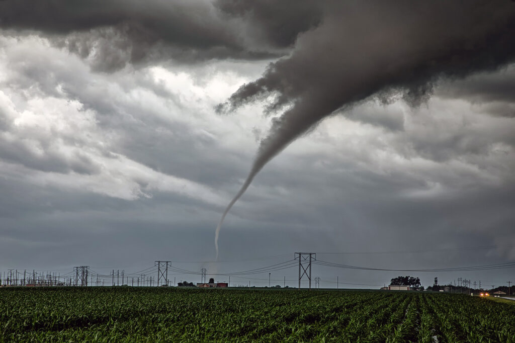
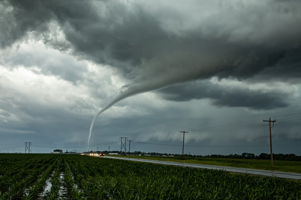
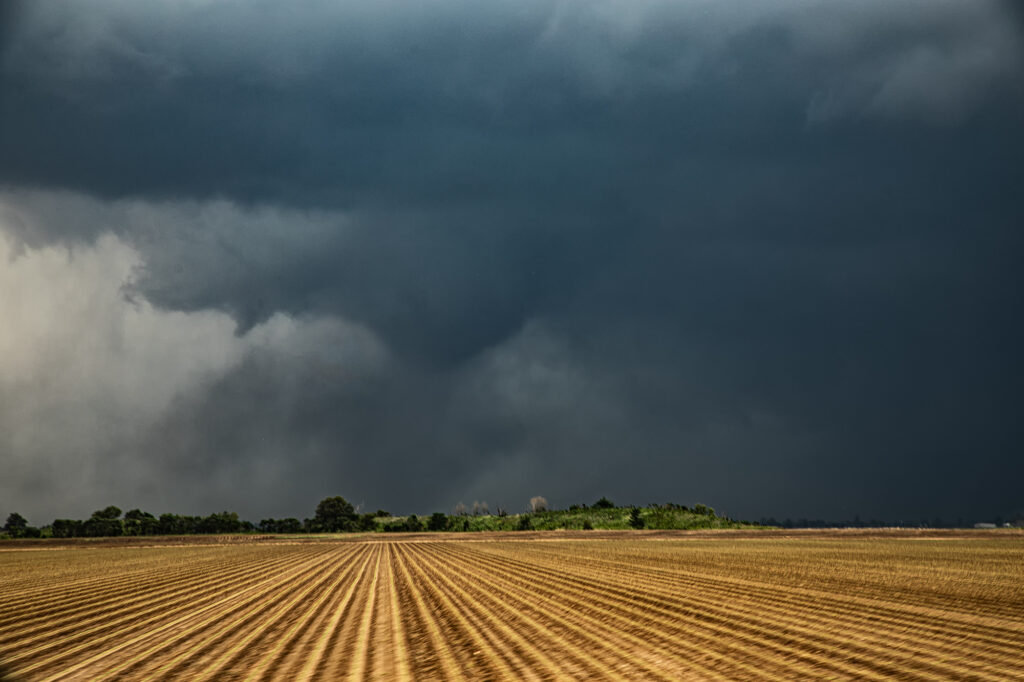
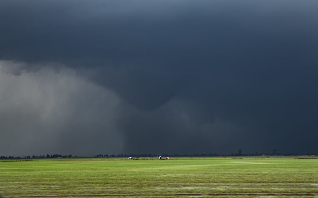
May 16th was advertised by SPC with a MODERATE RISK across the MS/OH river areas. It did not disappoint! Strong shear, high moisture and instability, and a slowly advancing front set the stage for what would be the most significant severe weather outbreak of the year so far. We started in Springfield, IL and blasted towards Sikeston, MO, which was my target. Storms formed west along the front and moved east and intensified. We decided to push west a bit and meet them as they came out of the Ozarks (a nearly impossible area to chase in!). As is often the case, we targeted the tail end storm, which typically gets the best feed of moisture, as it moved just north of Poplar Bluff. It had a great hook echo on radar and showed a strong velocity couplet. As it emerged onto the flat terrain, a truncated cone tornado formed and went on to be on the ground over 15 miles. It caused significant damage and was rated EF3. Another tornado formed just east of the first, a long slender elephant trunk shaped tornado, and ended up getting rated EF1. The supercell moved east across the Mississippi and Ohio rivers west of Paducah, and due to terrain and poor road networks, we couldn’t stay up with it.
More storms formed back west into southeast Missouri, so we pursued them. We caught up to them just west of Morley. An elephant trunk shaped funnel descended and touched down just west of town causing EF1 damage. Soon another EF1 tornado formed just to out northeast and eventually dissipated as it crossed the river. Numerous tornadoes occurred across this area during this event, causing extensive damage and unfortunately even loss of life. Our heartfelt sympathy goes out to those who suffered, including a tornado that directly hit St Louis. Please take the time to donate to local charities to help those impacted by these tornadoes and supercell thunderstorms.
April 26th Roswell, New Mexico Tornadic Supercell
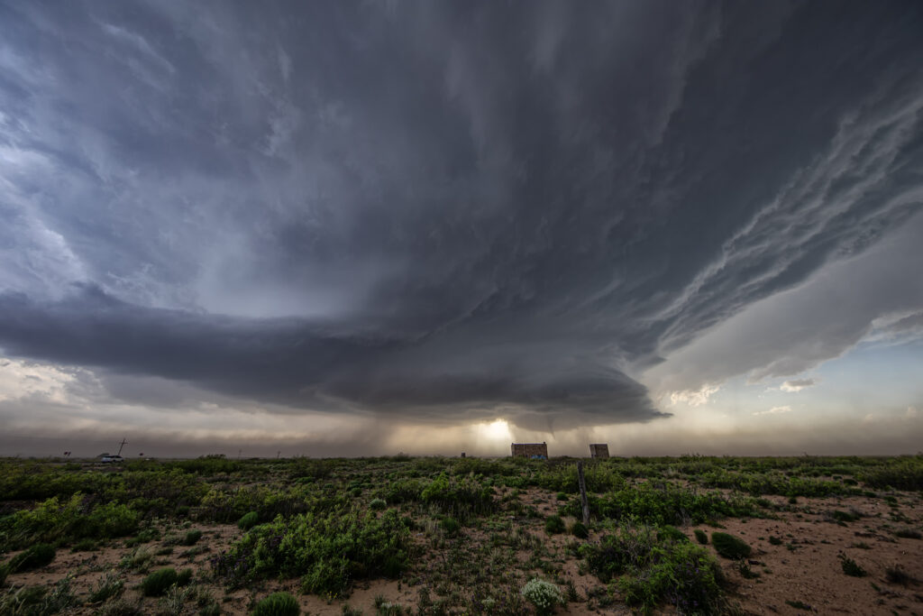
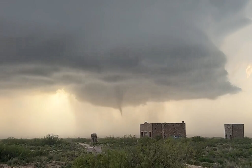
April 26th featured an upslope/dryline play in eastern New Mexico. Storms formed along and north of an outflow boundary. We intercepted the triple point storm that developed just northeast of town and kept back building at the triple point until it got so strong it moved southeast along the boundary. It didn’t take long in the highly sheared environment for it to start rotating strongly. Inflow winds of 50 mph fed the storm. There was so much dirt being sucked into the updraft at times, you could see the dirt cloud rise into the updraft base. Eventually the low levels started rotating as a very obvious mesocyclone formed. A clear slot wrapped around the meso and a long snaking elephant trunk shaped funnel, then tornado descended from cloud base. Dirt partially obscured it from time to time and it dissipated after about 5 minutes. The storm was a prolific hailer as ell we 3-4 inch stones reported. We stay with it until dark when it weakened. A fun day and a major powerful supercell was incredible to experience from birth to death. Enjoy the pics!
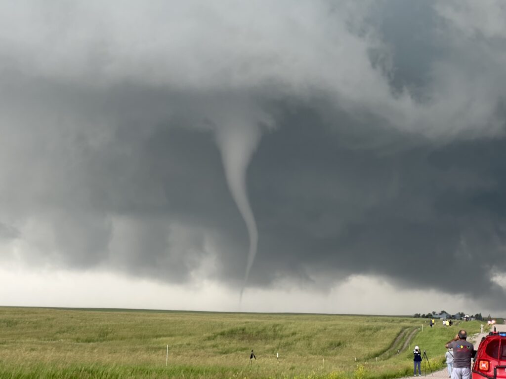
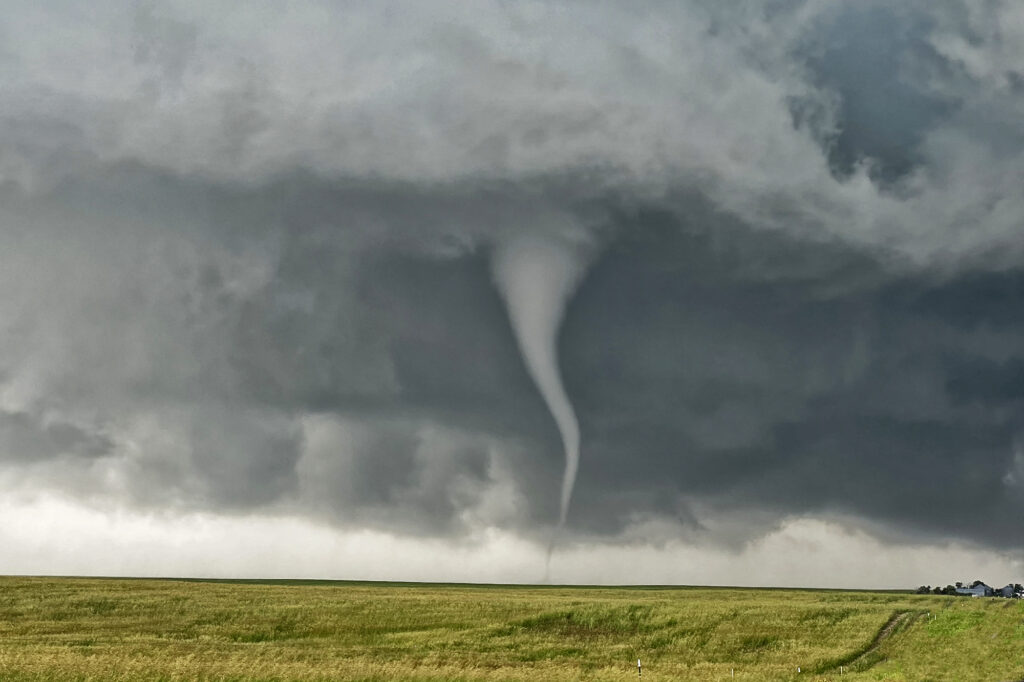
June 23rd Chugwater, WY to Scottsbluff, NE Tornadofest
June 23rd had significant potential in southeast Wyoming as well as southeast Colorado. We chose to play the Wyoming target instead of Colorado. And both produced tornadoes!!! When you get upslope flow into the Laramie Range in southeast Wyoming with decent moisture and instability, you chase there, plain and simple. Good shear and lift into the mountains were also present and by midafternoon storms erupted west of Chugwater. It took a bit for storms to become organized, but one such supercell over the town of Chugwater became the primary supercell this day. It spun east all the way past Scottsbluff, NE and produced at least a half dozen tornadoes, a few of which we were close to and became pretty photogenic! A Tornado Emergency was issued for one large tornado near town and fortunately did not cause any serious injuries or fatalities. Storm structure was pretty as well and the supercell also produced softball sized hail at various locations in the lifetime. A great chase day and fortunately the results were good for the local residents. Enjoy the pics!