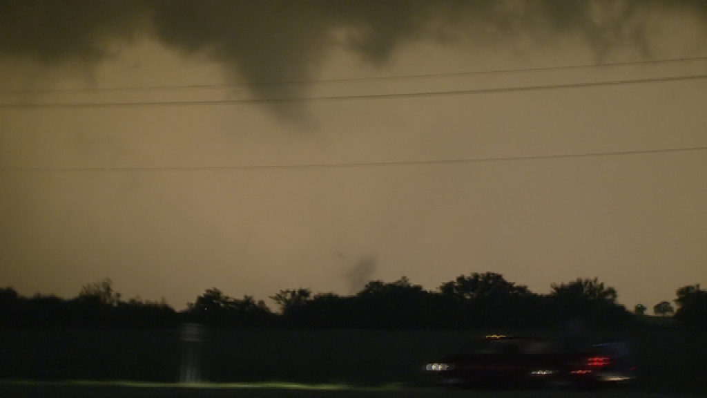
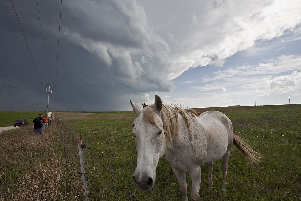
May 25th was kind of a let down for me. After a wild day before in Oklahoma, it certainly looked like the Missouri/Arkansas/Tennessee area was in for a big day as the system continued eastward. However, after spending hours waiting for initiation in Newport, Arkansas, we headed southwest towards Little Rock as storms exploded there. Of course, 2 hours after we left a tornado occurred just west of Newport. For sure it was one of those days. We chased several tornado warned storms, but something was missing. Maybe weaker 850 winds than further north into northern Arkansas and southern Missouri where numerous tornadoes occurred? We finally captured a nicely structured supercell that dropped a brief tornado just west of Memphis, Tennessee. The last 3 photos below were taken IN MEMPHIS, looking west across the Mississippi river (which was producing major flooding at the time).
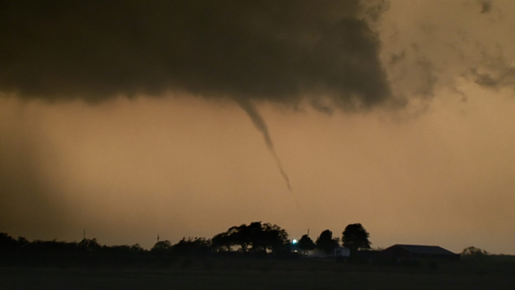
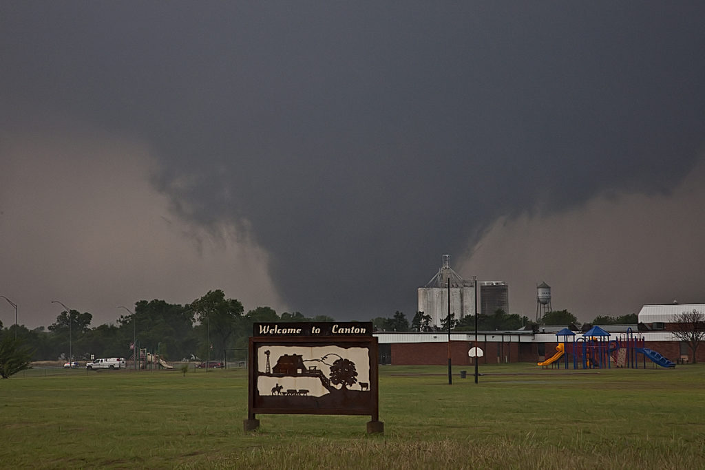
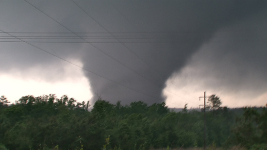
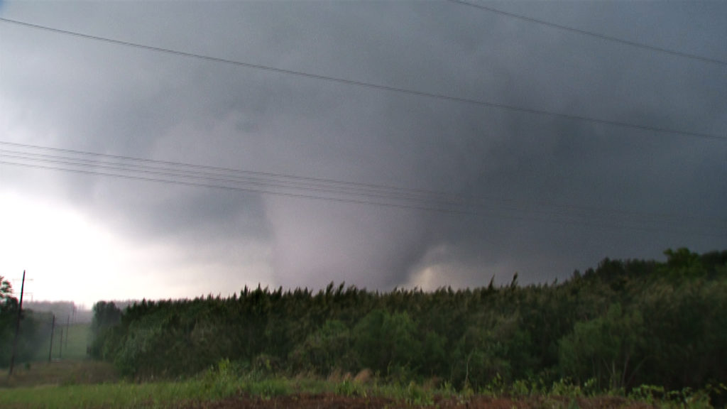
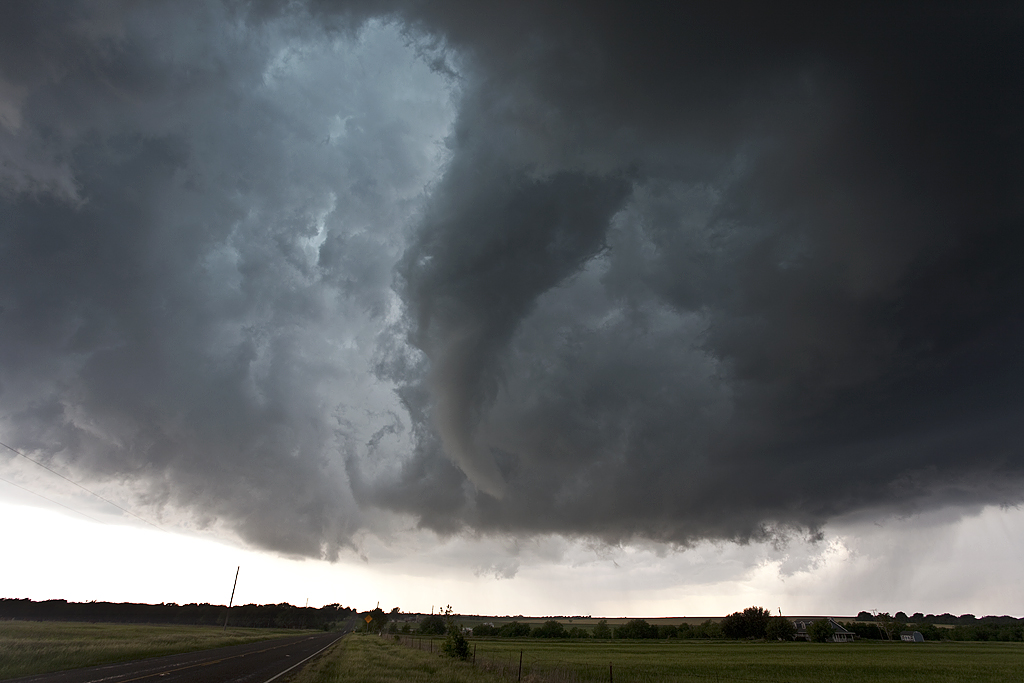
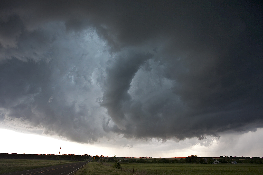
May 24th, 2011 Canton, OK Violent Tornado
May 24th certainly lived up to its High Risk billing. Supercells exploded along the dryline in western Oklahoma and quickly became violent. Numerous EF3 – EF4 tornadoes occurred with various supercells. We intercepted the Canton storm, which produced 3 tornadoes we could verify. Then we dropped south to Oklahoma City and intercepted two more storms that produced tornadoes as well. My heart goes out to all those who suffered personal losses this day. If you haven’t gotten involved or donated to the local Red Cross/or other agencies, please do so!
May 22nd, 2011 Joplin, MO Devastating EF5

May 22nd, 2011 was a day I will never ever forget. It was one of the most horrific experiences I have ever had chasing. One engrained deep into my mind for the rest of my life. Some decisions we made this day saved our lives. To be within 5 blocks of one of the most devastating tornadoes in US history and to be able to write about is not something I take lightly.
We started in Wichita, KS, expecting a big day in southeastern Kansas and southwest Missouri. Our initial target was an Independence to Joplin line. Things looked good early with ample moisture, high CAPE, and good surface winds. I was afraid of the weak upper level flow not venting precip far enough downwind to keep storms from being HP and quite messy, and in the end, this was exactly what got us in trouble.
The first storms went up near Independence, KS and were quite explosive. They turned into a pile of outflow dominant cores quickly and were impossible to chase. These highly electrified cores were fun to watch as the CGs bounced around but updrafts never looked like they were ready to drop a tornado. Just too much outflow out of control, and too HPish.
As we moved from storm to storm, we continued eastbound towards the Missouri border as outflow spewed south of us. We knew we had to get back south and east of the OFB or we were in for a long evening. Storms would develop on the dryline to our south and move northeast, crossing the boundary, spin, become undercut and weaken. We chased a number of these cores, slowly moving east through the towns of Rosewood, Columbus, and Cherokee and into Missouri.
As we continued into Missouri, northwest of Joplin, one storm interacted with the boundary, developed a well shaped wall cloud, and became tornado warned. It pummeled us with large hail golf ball/tennis ball sized, but also crossed into the cold air and weakened. This was the first storm that became tornado warned in Joplin.
What happened next occurred at a time we were not really chasing, but with our guards up at all times, as one should. We came southeast into town and dropped south on Range line Road, (71Business) not aware of what was soon to happen to our west. A storm was developing on the dryline and started spinning before it hit the OFB. As it hit the boundary it became violently tornadic in 15 minutes! The rest is a historical section in US tornado events. This storm turned hard right along the rolling spinning outflow boundary and quickly developed supercellular features and was extremely wet. HP storms are not fun to maneuver around as you cannot see what is going on under the mesocyclone.
Before this, we headed down Bus 71 and found a gas station to stop and refuel, and those who really needed to use the facilities were allowed out as it had been a long while since we’d taken a break. Fortunately as it happened, the attendants at the store would neither allow folks in, nor allow us to pump gas, because we were under a tornado warning from the storm that had already crossed the boundary and moved into cold air. We pondered where we could use restrooms and decided to get back into the vans and head south looking for another stop. At that point I looked at the latest radar update and the storm now had a violent hook on it. I knew we had to act and act fast! I was pretty certain there was a tornado coming at us and at a steady pace, but had NO idea how significant this tornado was.
As we continued south on Range line Road, power flashes were seen to our immediate west, only 1-2 miles away. I knew we had to do whatever we could to get out of the way and NOW! We were 2-3 miles north of I-44 and I knew we had to get there, then head east and drop south on 71 to get out of the way forever! Very heavy traffic was on the road, and traffic lights every block, so progress was very slow and the situation became more and more intense. As we progressed south, we started yelling at people to take shelter. They would point and laugh at us as we continued steadily south. I was concerned about folks at the many fast food places IN LINE to order at the drive through lanes, totally unaware of the approaching tornado. We honked, yelled, did whatever we could to inform people of the approaching danger. One guide called out to take shelter under the Home Depot covering, but looking up at the black spinning mass approaching I knew that was not an option. The Home Depot was totally destroyed with fatalities inside.
It was beginning to look like we were in big trouble when suddenly the power went out, including the traffic lights. We were moving again! We started weaving around traffic and charging towards the on ramp only a few hundred yards or so away. Just to our west, you could see wrapping rain curtains around the tornado as they hit us with 60-70 mph winds and pieces of debris falling on the vans. We knew we were in huge trouble if we couldn’t get to the on ramp that seemed miles away. The eastern edge of the tornado was getting close now!!!!! We had to head east/northeast on I-44 to get to 71 south, and that was the exact path the tornado was moving in! People were driving slow with the intense wind and rain/debris, and we had to weave around them to get east and fast. We made it to 71 south and blasted 5-6 miles south until we were clearly out of the way. Many tractor trailers were flipped and destroyed on the Interstate just up the road just seconds after we got out of the way.
Our entire tour, including the guides, were pretty shook up by what had just happened. We had no idea how intense this tornado was and found out later just how strong it indeed was, an EF5. Only after stopping for a few minutes did we start hearing reports of heavy damage and as we headed south we noted many emergency vehicles heading north towards Joplin. It would be well into the evening before we understood the true magnitude of the disaster that had occurred.
As Rich Hamel stated (and I borrowed some of his content here!), in hindsight, three seemingly random events might well have saved us:
- The gas station refusing us service. If they had, we very likely would have stayed north of the tornado.
- The decision not to shelter at Home Depot. As stated above, the Home Depot was completely destroyed.
- The power going out, taking the traffic lights down. If not, I’m not sure we could have gotten moving fast enough to get out.
We drove south and intercepted another tornado in its late stages near Southwest City, MO as the tornado moved away through the trees and debris was falling, and then continued south to Siloam Springs, AR to head west to our destination for the night in Tulsa. As we headed west from Siloam Springs, a stout stovepipe became illuminated by lightning as it crossed the highway in front of us. Debris was strewn all over with pieces of insulation, sheet metal and chunks of woods all over the highway as we maneuvered around it.
We finally called it a night after that, but had one more surprise in store. As we entered Tulsa where our hotel for the night was, we ran into a big hail core from another storm that had just popped up to the southwest. It was on top of us before we knew it and soon we were getting hammered with huge hail! We witnessed two hail stones of at least tennis ball size slam into my windshield, which literally bowed with the force but somehow did not shatter! Then off to our left KABOOM! A bright blue flash and the power went out over the entire southern part of Tulsa. A power main must have been damaged by hail is all we can guess, but of course with everyone jittery from Joplin, people were worried about a rain-wrapped tornado. In only a few seconds, the power was back on and we finally got to the hotel, ending a long, dramatic chase day.
Thanks Rich Hamel for your account and SUPERB driving this day. Thanks to all SLT guides, Tom Howley, Andrew Gardiner and Matt Jones for your steadfastness in getting us out of a horrendous situation.
(NOTE THS CHASE ACCOUNT HAS BEEN EDITED TO CLARIFY THE EVENTS OF THIS DAY.)
Here is a map from Rich that shows the path we drove to get through Joplin, along with the tornado’s path.

Here’s a shot of the Siloam Springs, Arkansas tornado courtesy of tour guest Justin Noonan:

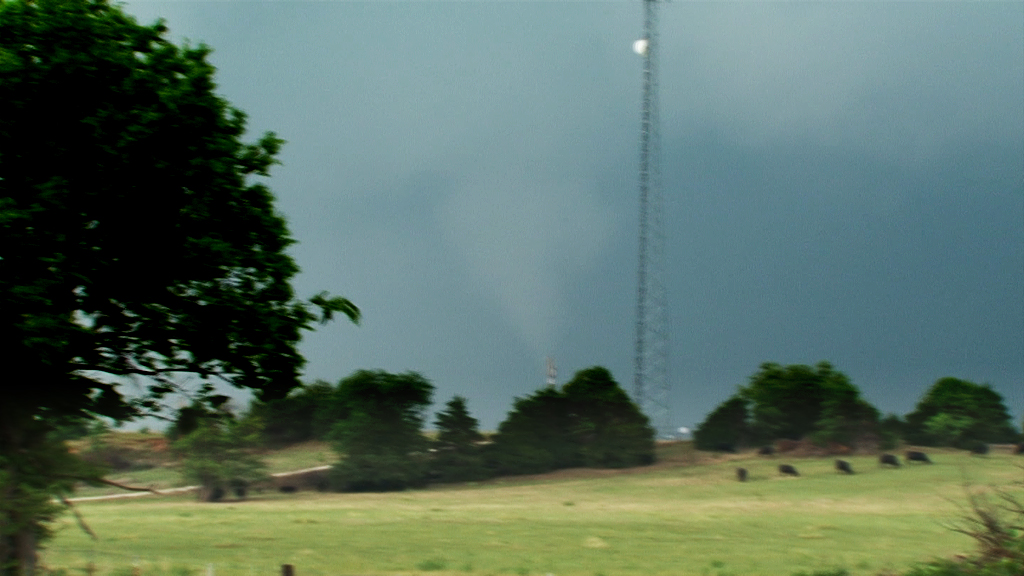
May 23rd, 2011 Homestead, OK Tornado
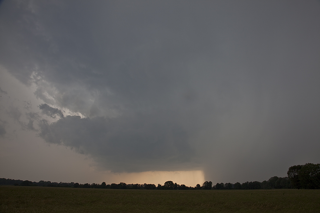
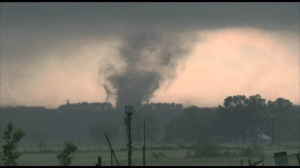
Things looked decent this day. However, due to high cloud bases, the tornado threat never really materialized. We went west from Enid, OK to play the dryline and encountered a nearly stationary supercell, albeit high based. This cell eventually dropped a slender truncated elephant trunk shaped tornado that was on the ground maybe 3-4 minutes. We later dropped south to another supercell that spun like crazy, and then abruptly died. Very wierd day, but at least we did catch a tornado. Thanks Rich Hamel for your use of your tight shot of the tornado. I had the wrong lens on my camera.
May 21, 2011 Topeka, KS Tornadic Supercell
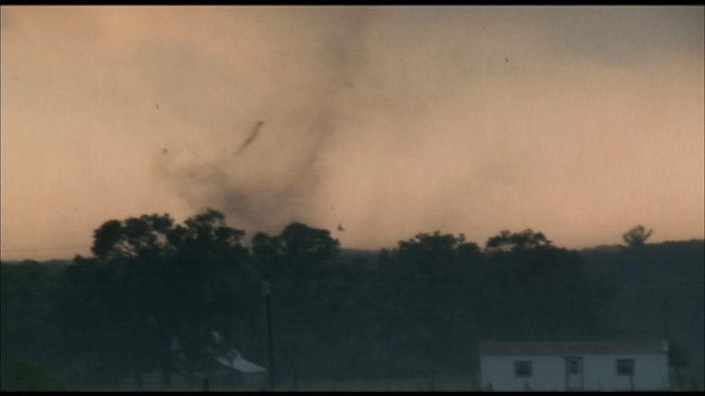
Chased May 21st near the Topeka area. Shear didn’t look that spectacular, nor did moisture, but with some Kansas magic anything can happen. We sat just west of Topeka watching towers go up north and southwest. Finally we committed to two storms southwest of us, one left mover and one right (that ended up developing into the Topeka storm). This storm had superb structure almost its entire life cycle, and finally produced a tornado near Lake Perry that I could only get a 30 second video of. All the shots below are from my 5d Mark II, but one last video grab from my Z7U of the tornado as we lost it in the trees. ARRRGHH! To be sitting there the entire time and then to not be able to get close to this tornado was frustrating to say the least.
May 8, 2011 Presho, SD Brief Tornado
We ended up in central South Dakota this day on what appeared to be a pretty marginal situation. Nonetheless a tornado watch was issued for the dryline in South Dakota, down through northern Nebraska. We positioned ourselves near Presho and watched a high based supercell spin like crazy and eventually produce this brief 2-3 minute weak tornado. It also produced an amazing cg display and dumped golf ball sized hail on us. Freakiest thing this day was what happened on the way to our hotel east near Chamberlain. As we were going down into the Missouri river valley, a freak gust of wind from a decaying storm hit us with such force, it picked up pebbles from the side of the road and blew out all the windows on the drivers side. Other than being shaken up a bit and a couple glass cuts, everyone was fine. Later we found out others had also been hit by this strange wind gust. This put us out of commission the next day as we had to get glass installed. Caryn and her on call group witnessed a tornado near Harrison, NE on that day.
April 27, 2011 Mississippi/Alabama Violent Tornadoes

First of all, my heart goes out to everyone who suffered a loss on this horrific day. One of the worst tornado outbreaks and highest number of fatalities in US history. A very sad day indeed.
It was evident for a couple of days before this event that this would be the final day in a 3 day tornado outbreak for the US, and that this would be the most violent and wide spread. We started this day in Jackson, MS positioned to move in any direction. The plan was to intercept storms in MS, then continue moving east into Alabama, and eventually end up somewhere around Tuscaloosa by mid afternoon. However, fate would have it that this would never materialize for us. We jumped on the first storm that developed southwest of Jackson as it quickly moved towards Philadelphia, MS (and would create destruction and death during its entire life cycle through Tuscaloosa, Birmingham and into Georgia). One event changed what we would do the rest of the day. As we were 10 miles from Philadelphia, MS, well ahead of the storm, a vehicle with a young man and two girls ran off the road, slid down an embankment and hit a tree going 50 mph. The car spun around in a circle as we watched in horror. We immediately stopped to render assistance and called the state patrol. Fortunately nobody was seriously injured, but now the supercell was overhead and racing away from us at 60 mph, while there was no possible way through the trees, hills and winding roads to stay with it. The rest is history. We tried in vain to catch up to it again, and quickly learned of the strong tornado it was now producing, less than 5 miles in front of us, but we were never to see it. I believe all things happen for a reason, and I will never know why we were never to chase this storm.
We dropped south towards Meridian, MS to get back on the interstate as another supercell formed and raced past us (no road options to chase it) and also became tornadic. It was already becoming a frustrating day and it had just begun!Storm motion of 60 mph, poor terrain for chasing, lack of roads and low visibility led me to rethink the entire rest of the day. I felt the only way to have any reasonable chance of intercepting tornadoes would be to get 30-45 minutes ahead of the supercell, find one of the few clearing to view it, watch it approach and fly past us, then drop south on the next storm and do it again. This approach finally paid off, however we were never able to get into Alabama, and instead stayed in the rough terrain in eastern Mississippi.
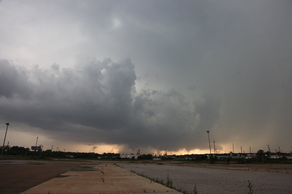
A tornadic supercell formed southwest of Jackson and right turned, heading east/slightly northeast toward Newton/Hickory, MS. we dropped south of town about 3 miles and found a great clearing to view it. The storm, already tornadic and a killer, quickly approached. As it did, a wedge tornado was quite evident over the hills and trees to our southwest. About 2 miles west/southwest of us another tornado materialized in an instant and approached us at lightning speed. As this grey cone moved dangerously close to us we blasted south out of its way and watched as cars were driving directly into the path! We honked, stopped and waived people off as the tornado, now another wedge crossed the road at the exact spot we were parked and viewing it from, uprooting trees and flattening power lines in its wake. We drove back north as the strong tornado raced away from us and crossed I-20. I was fearful for vehicles on the interstate and the town of Hickory they were directly in its path. We drove to the interstate and went east to see if we could still view the tornado (an EF3), but now it was rain wrapped and long gone. As we dropped south through Hickory we encountered a couple destroyed homes with rescue vehicles already on the scene. We decided it best to continue south (since help had arrived) and intercept the next supercell also tornadic now just northeast of Turnerville.
We dropped south on highway 503 and headed southwest on 18 towards Turnerville. At that point we stopped, although the view was partially obstructed by woods and hills. I could see a very large multivortex tornado directly southwest, rapidly approaching. It wasn’t until later that we learned of the fatalities just north of Turnerville as numerous homes were destroyed by this EF4 tornado. At the junction of 18 and 503 a barbeque place had a couple of people in it. We warned them of the approaching danger and they left. Amazing how oblivious people are to a dangerous situation. We told them to get south and far away from this large, violent monster. The tornado turned into a fat cone, then wedge as it blasted past our location less than a quarter mile south of it at 60 mph. The noise was horrendous, louder than any tornado I have ever witnessed. Everything in its path was demolished. Trees, houses, power poles, everything. We saw the tornado was heading directly into the small town of Rose Hill, and headed up 18 towards town. Trees and power lines were down and after some local help and moving debris out of the way, we proceeded into town. Rose Hill was directly hit by the violent tornado about 3-5 minutes before we got there. We found much damage, homes destroyed, animals killed, and people in need of assistance. At this point we abandoned the tour and rendered assistance. One family we immediately found lost everything. Their house was totally leveled, their barn destroyed, vehicles and horse trailer thrown and demolished. They were trying to round up their horses who of course were totally spooked and uncontrollable. Dead chickens lay around. The father, mother and daughter survived due to a freakish event. About 5 minutes before the tornado hit, their neighbor had called them and asked them to come over for a minute. The whole family walked over to the neighbors only a few minutes before the tornado hit. They surely would not have survived had they stayed in their house (without a basement or shelter!).
With our day now done, and authorities on the scene, we left our search and rescue efforts and headed back towards Jackson for the night. We knew the supercell still had this violent tornado in it. We let authorities know this. Later we discovered the tornado had continued nearly 65 miles and leveled a big part of the town of Snell, where 7 fatalities had also occurred. A horrible discovery.
I am still amazed in this day and age of the lack of concern by a vast majority of people when faced with a dangerous situation. The NWS, SPC, local authorities, etc all approached this day and through the day with great reaction to this historic situation. Still, hundreds have perished, and maybe the toll would have be considerably larger, had not the agencies made sure the word was spread and warnings issued with as much lead time as possible. People seemed to have the idea that nothing would happen the them, it would always be someone else. This event proved otherwise.
I am pleading to every person who reads this account to get involved and donate your resources to help those in need. It will be a long time before things return to any sense of normalcy in the southeast. Please get involved!
Here is a video I put up of the tornadic events from this day.
April 26, 2011 Ben Wheeler, TX Tornadoes
A bit of a frustrating day today for us as there were so many cells to choose from. We targeted the initial supercell that formed near Hillsboro, TX (again) and followed it until it finally produced tornadoes near Ben Wheeler in Van Zandt county Texas. The storm just couldn’t focus rotation in one spot for long before occluding and the meso jumping ahead. Finally, just west and then north of Ben Wheeler, it produced two truncated slender tornadoes, followed by a 5 minute multivortex which caused damage to roofs, trees and power lines. Below are only a couple photographs and two video stills. Check out the Youtube video of the multivortex tornado.
April 25, 2011 Hillsboro, TX Tornadic Supercell
April 25th took me to Texas. Early day indications looked like northeast Texas would be a sweet spot. We headed early to Paris only to be disappointed by early afternoon convection that was slightly elevated. Meanwhile a tornadic supercell developed southwest of Ft Worth and produced at least 2-3 tornadoes before we could recover and make the 130 mile trek. We did catch up to it near Itasca, TX and encountered a pretty structured supercell that produced two brief tornadoes between Itasca and Hillsboro. Nothing worse than being 130 miles from a nice supercell and hearing about the tornadoes that occurred before you have a chance to reach it!
April 22, 2011 Southern Oklahoma Tornadoes
April 22nd took me to south central Oklahoma to play a dryline/triple point setup. Good shear, albeit a bit weak upper flow, excellent instability, dewpoints in the upper 60s and lift along the dryline would spark severe storms this day. Storms became HP fairly fast due to the weaker upper level flow. I intercepted a couple of supercells near Paul’s Valley, that later produced tornadoes near Stratford, OK. HP structure was good and they were extremely electrified. We also viewed 3 tornadoes from these storms.