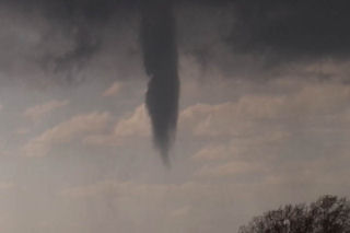
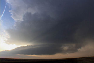
March 27 took me to southwest Kansas. A triple point set up was to be the focus for initial supercell development this day. Models showed a couple waves of convective development with the advancing trough and cold front with the dryline and triple point to be the focal point for potential tornadic supercells by late afternoon. However, the first wave of convection of the day, which developed late morning and early afternoon, was the only wave to happen. Fortunately I left early for my target of Dodge City, Kansas. After driving through blizzard conditions in Colorado, I got in front of the advancing cold front just west of Ogalla, Kansas on I-70. I dropped south to get to my target, and at the same time a supercell developed just east of Dodge City. This storm rapidly intensified and produced several tornadoes. I had to core punch the FF core to get to the updraft and managed to break my first windshield of the year with 2.5″ diameter hailstones. By the time I got to the updraft, the first LARGE tornado (F3) was dissipating. I managed to see it as it dissipated, but missed the biggest action by 10 minutes. Two other tornadoes and several funnels formed. Also included in the photos, was an LP supercell from the night before that my wife Caryn and I intercepted near Boise City, OK. Check out the photos below.