OKC at 7:30, we made our way to Topeka, KS. My optimism regarding the potential for visible tornadoes had evaporated the evening before due to the upper-tropospheric wave responsible for surface cyclogenesis being progged to fill/weaken rapidly due to stretching deformation (a tendency apparently underestimated rather badly by most models 2-3 days prior to the event). Nonetheless, we were optimistic about the likelihood of HP supercell thunderstorms initiating along the frontal boundary from NE KS to S IA/N MO. The focus of our afternoon data analysis was on finding the likely initiation point and best environment for daytime supercells; NE KS to S IA is an unacceptably large target area when storm motion vectors are going to be 35-40 kt. We became convinced that initiation would be near Falls City, NE with rapid intensification and maturation of supercells across extreme NW MO. Our mistake was that we didn’t have enough confidence in this to set up shop downstream of the expected initiation point – there have been many times when I overshoot the area of initiation and have to backtrack westward.
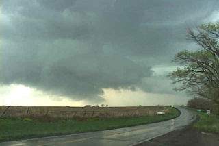
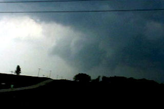
We moved north from TOP on Hwy 75 at about 4pm CDT, observing congested (albeit mushy) CU and TCU to our NW through E. At the Hwy 36 junction we observed glaciated convective towers to our not too distant N and NNE; additionally, the developing congestus N through NW was being visibly undercut by scud apparently associated with the leading edge of the cold front, so we continued on eventually crossing into MO east of Falls City. When we turned north on Hwy 59 in east-central Holt county we could make out much cloud base structure associated with our target supercell. We observed a well-defined dry slot with developing RFD gust front; to the NE of that was a very ominous block-shaped lowering/wall cloud that definitely had a tornadic appearance. We were too far to discern any detail. We continued stair-stepping N and E and when we were just east of Maitland on CR A we observed a fully occluded wall cloud with truncated cone shaped funnel cloud about 4-5 miles NNW of our location; the wall cloud and accessory scud tags were wildly rotating and I estimate its location to have been close to the town of Skidmore; I don’t remember the exact time (too busy navigating to keep a log) but it was probably around 6-6:15pm and we were too distant to confirm/deny that the funnel cloud was actually a tornado. I would not be surprised if a large tornado occurred somewhere N or W of Skidmore.
Unfortunately, we had been effectively outflanked by the storm so could not achieve the desired position due E or ENE of the meso. New mesocyclogenesis was rapidly underway to our immediate ENE and the RFD gust front was loaded with vorticity and wild, fluid vertical motion. Soon thereafter, the storm tended more to HP characteristics and developed a menacing rear-flank core with encircling shelf cloud. However, it refused to give up on trying to develop a forward flank updraft/meso as inflow stratus continued to fly into the storm from the E and SE and scud rose and attached to cloud base at the E edge of the core. East of Conception Junction in eastern Nodaway County we were briefly overtaken by the southern edge of a tightly circular precip curtain, the apparent center of low-level circulation passing just to our north. Our winds turned from SSE to W, gusting to near 50 kt. We finally got to the junction of US Hwy 169 and CR O at Gentry. The storm was now decidedly HP in character with a substantial surging RFD core/gust front bearing down on us from the SW and a less menacing FF core to the NW; we were sitting in the notch at this crucial intersection with no more east option. To our immediate SW and almost overhead a patch of cloud base was swirling wildly as the RFD core pivoted around from the W and SW to overtake us.
The rotating cloud base moved quickly to our east across open pastures near Gentry, MO and we were forced north into the SW edge of the FF core, letting the more dangerous RFD core pass to our SE. After the maelstrom passed we once again attempted to outflank the storm but decided to blow it off at I-35 in favor of targeting a more isolated storm SE of STJ. Downloading radar as we drove (my goodness gracious, I never failed to get a wonderful cell phone connection yesterday), we headed directly to I-35 exit 40 at Lathrop. Too late (we heard the warming for the spotter-indicated tornado near Edgerton); it was an interesting looking soda can LP storm (we got 1″ diameter in the vault and cars were briefly blocking the interstate at an underpass) with an amusing array of sheriff deputies and other gawkers staring up at the sky. On the way south, we were mightily distracted by a ridiculously explosive convective bomb forming over STJ. As we drove south on the interstate we watched as the fat convective tower expanded, grew, overturned and went crazy. We turned around at Lathrop and stopped west of Cameron on Hwy 36 for a very entertaining lightning show (great anvil crawlers in the vault/overhead anvil). Stayed around until the storm lost supercellular characteristics and lined out.