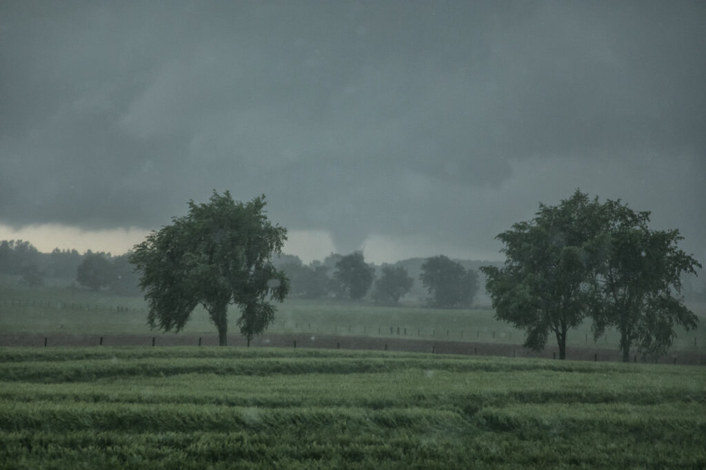
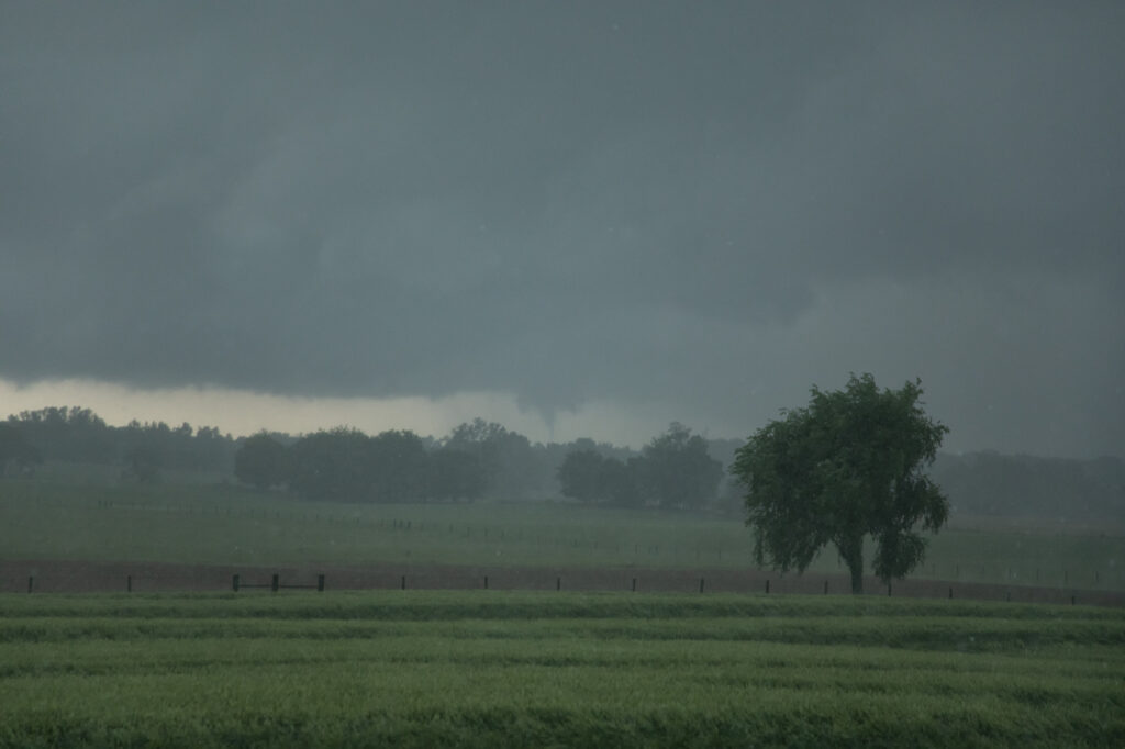
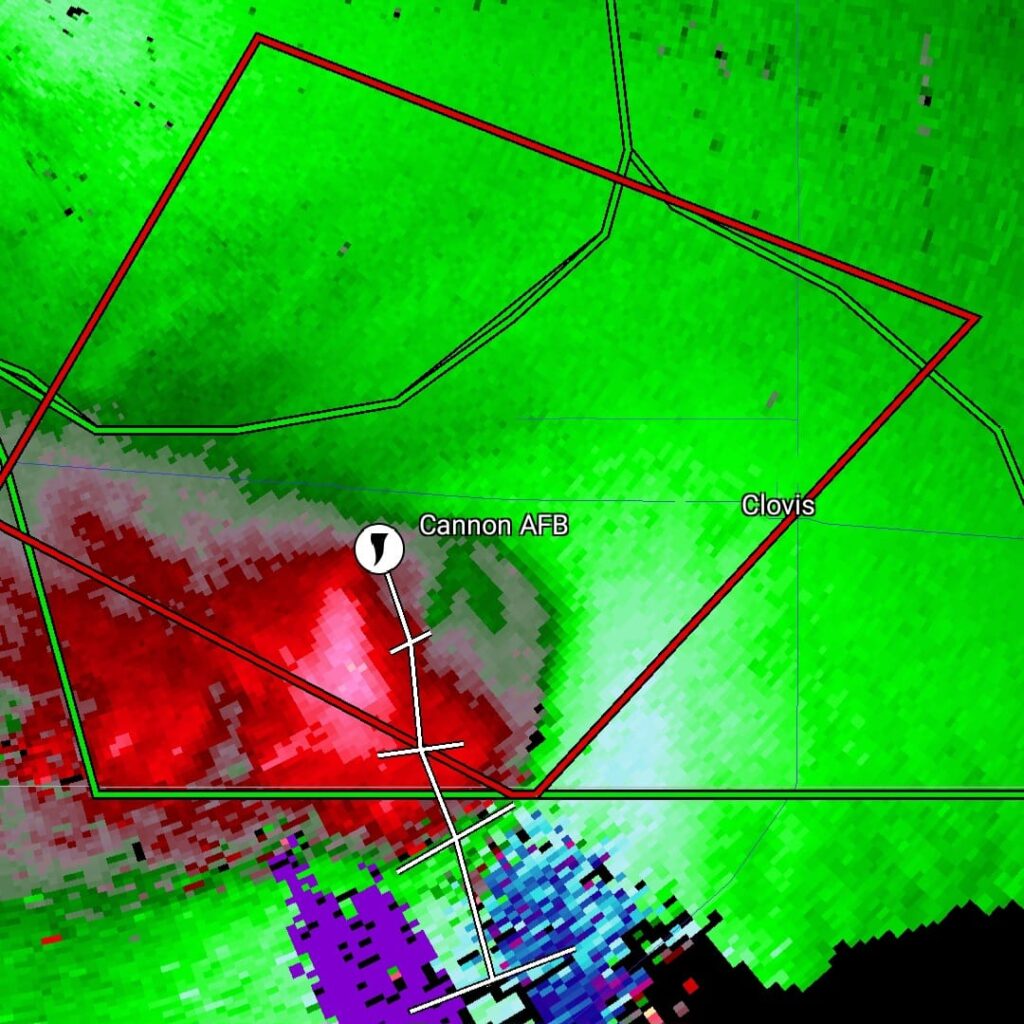
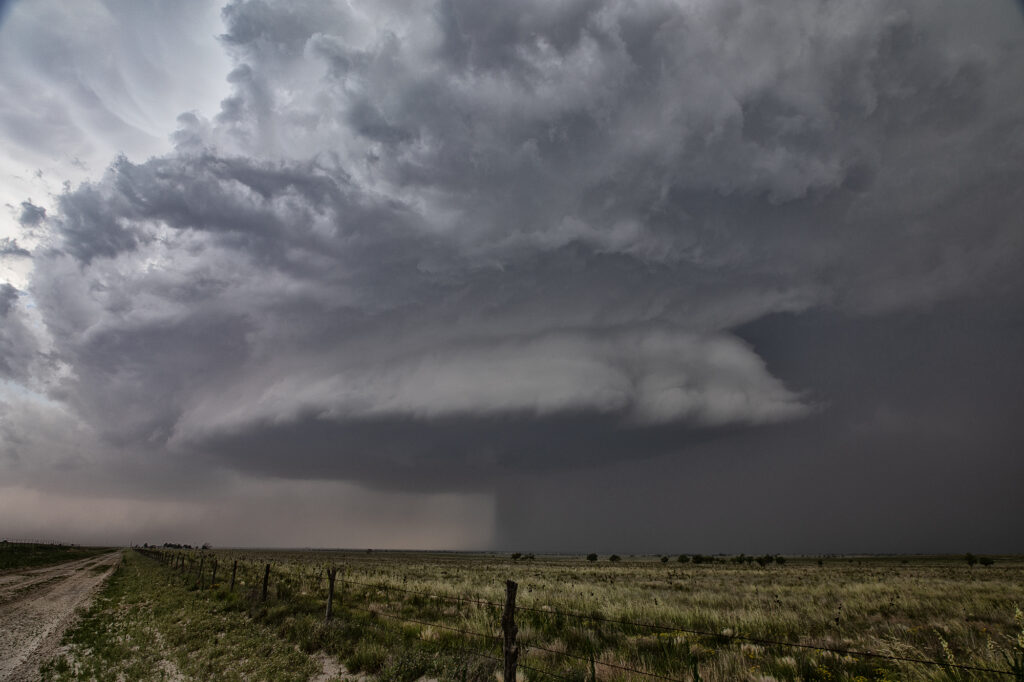
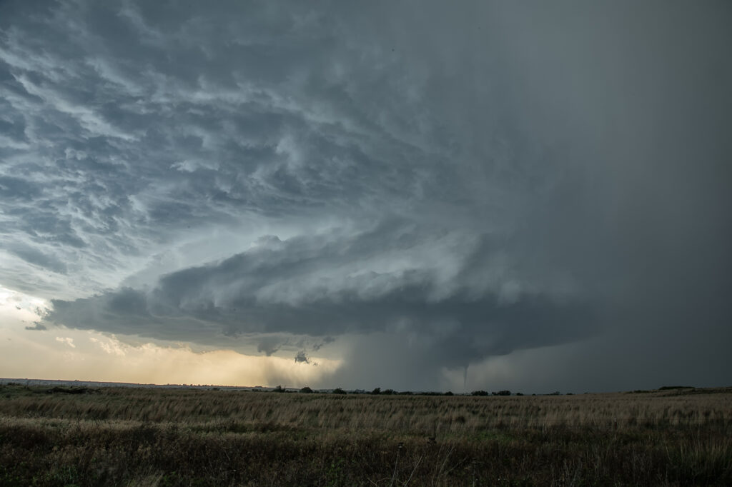
May 29th was a marginal day at best. Southeast Colorado looked like the place to be. However, with moisture pooling along a boundary in east central New Mexico, I had a hunch that would produce decent supercells late in the day and evening. The Colorado target got interesting and produced a couple tornado warned storms ( See the previous chase account for the Prime Time Minitour!!!), but I chose to wait and see what would happen in New Mexico. I was not disappointed!!!! By early evening as a short wave trough approached, storms developed northwest of Clovis. It didn’t take long to see they were anchored and would start spinning quickly. As we approached the northeast side of Clovis, a tornado warning was issued. Numerous images from various locals and also my defunked video camera showed what appeared to be a cone tornado northwest of town. The NWS in ABQ is currently validating the tornado based on images, video and local chasers in the area. We nearly had the storm to ourselves, which is quite rare in this day and age!!!! We dropped through Clovis and ended up north of Portales, NM and sat and watched the storm spin like crazy. It was constantly tornado warned. The structure was absolutely top notch, even in the dark and hook after hook formed on this anchored supercell! Finally, by late evening, things started winding down, so we drove to Amarillo to our hotel for the night. One of the BEST structured supercells of 2024, even in the dark! Please enjoy the pics and NO they are not photoshopped!!!!

May 29th Southeast Colorado Tornado Warned Supercells
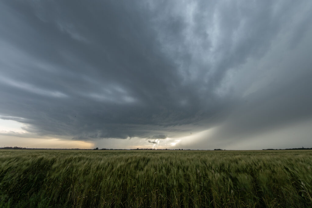
May 29th brought the last tour day of the Prime Time Mini-tour and Mother Nature brought some nice storms for the ride back to Denver. Started the day in Lubbock, TX with a plan to chase around the Springfield, CO area. Moisture started to mix out in that area, but a nice cumulus field started to build just west of Lamar as a weak La Junta low was forming. We headed for that area and watched from just south of Highway 50 as cells developed between Caddoa and Lubers. As the cells consolidated, lightning became more frequent and we got some nice lightning photos. The southernmost cell then became severe warned and we headed towards the east side of Wiley to stay in front of the strengthening southern storm. After a short time, we had to reposition to the east again along county road 196 and then south to Highway 50. During this time, the cell just to the north of our storm became tornado warned (radar indicated). Unable to get closer to the northern cell, we were able to watch that supercell and the southern LP supercell from our position. As both supercells began turning hard right over and just to the east of Lamar, we took dirt roads to get to a great vantage point looking over open land and observing both cells. The northern supercell was once again was radar indicated tornado warned, but no tornado was observed nor reported. The storms were nearly stationary at this point, moving southeast very slowly which allowed us lots of time to watch and admire. As darkness set in, we decided to start our 4 hour drive back to Denver. Working our way around the south side of the storm, we were treated to an incredible view of the structure of the southern LP cell, causing us to stop and take more pictures. A great day was had by all, super way to end the 4 day tour!


May 28th Morton, Texas Supercell with HUGE hail
May 28th set up had a dryline in west Texas, with strong southeast winds bringing modest moisture westward. Moderate CAPE developed as well and storms formed mid afternoon along the dryline. Storms pulsed quite a bit, and due to straight hodographs, storms split and many mergers occurred. Eventually a supercell developed, anchored near Morton. Structure became better, but due to modest moisture, the cloud base was too high to produce tornadoes. As it moved east it encountered a boundary and spun nicely. After several cycles, it produced 5 inch diameter hail west of Lubbock! We blew it off as it weakened and played further south with a supercell that had softball sized hail. The tornado threat this day was quite low due to high bases, but with strong shear in place and low freezing levels, storms were prolific hail producers.

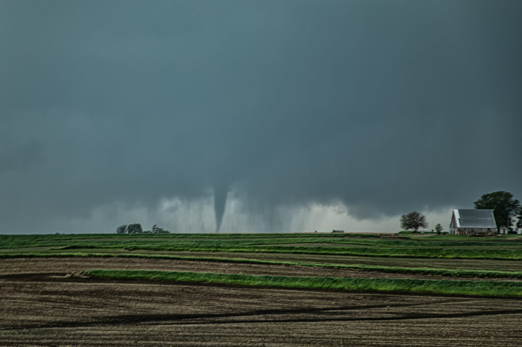
May 23rd Eldorado, Oklahoma Large Violent Tornado
May 23rd was the final day of Tour #4, the Prime Time tour. As often occurs, the final day of the tour would be quite eventful!!! A triple point boundary was present north of Childress, Texas. Good moisture and instability were present as well as increasingly favorable wind shear. Mid afternoon storms formed at the triple point. They quickly became severe for large hail. As they moved the boundary, they weakened and died. Soon other storms formed at the same spot and also became severe. One also became tornado warned, but did not produce. Another cell formed to its southwest and eventually merged with the lead cell and also became severe and tornado warned. We stayed with it as it tracked southeast along the boundary. Just northeast of Eldorado, Oklahoma, a lowering formed in the 70 dewpoint air and started spinning. Soon a tornado formed. This tornado morphed several times from nearly a wedge, to a cone, to a multivortex and another cone before dissipating. Quickly a spectacular barrel tornado developed and tracked slowly east. Our position was perfect with the sun lightning up the barrel and collar cloud making for a spectacular sight! Just an amazing day and thankfully the tornadoes hit no towns! Enjoy the pics!


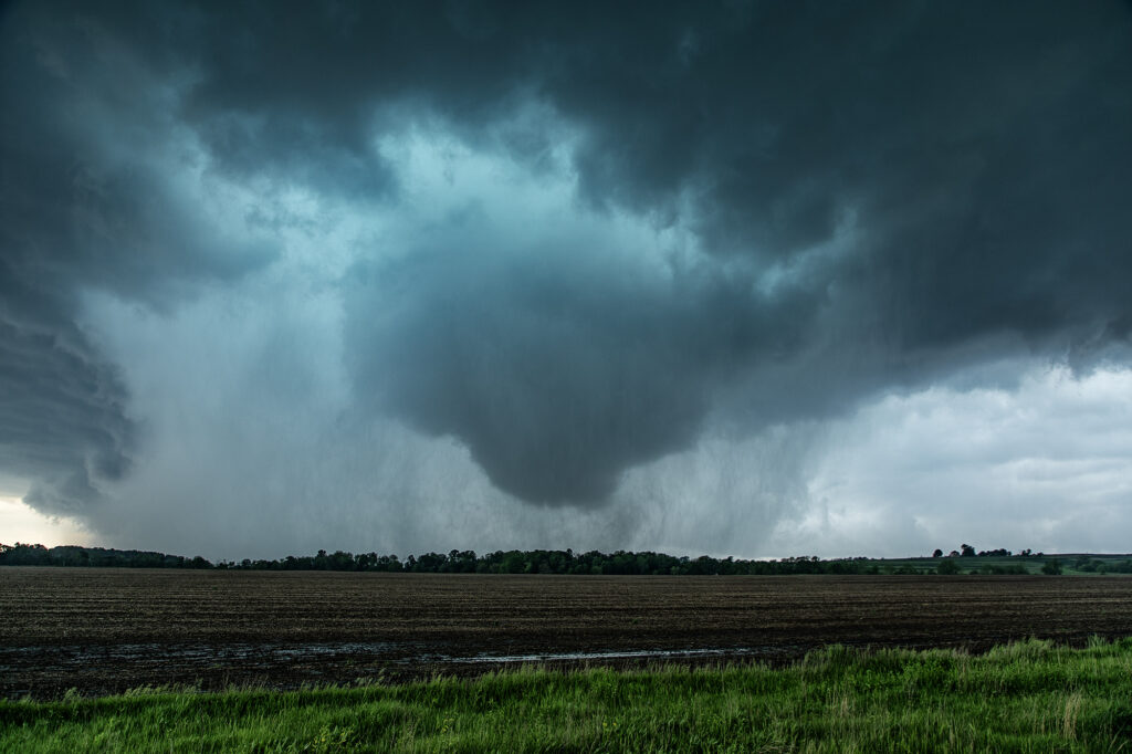
May 21st Southwest Iowa Tornado Outbreak
May 21st was a high potential set up in Iowa. A strong dry line, with fantastic shear, high CAPE and deep moisture would create a very dangerous environment in Iowa. By early afternoon storms exploded along the dry line and intensified as they moved east. Initial storms were not tornadic, but as the afternoon progressed, low level shear increased and tornadoes occurred with many storms! Our first tornado intercept was near Red Oak, Iowa as a supercell started spinning hard. The tornado went from a slender elephant trunk to a stovepipe and persisted for several minutes. The second tornado formed southwest of Carbon. It started as a big bowl, then vortices spun up and wrapping rain curtains were rotating violently around it. With motions of 60 mph we had to get out of its way as it approached us within a mile. The next tornado is now probably the most well-known. A strong multivortex tornado formed to our south near Corning and intensified as it moved northeast. It eventually turned into a raging F3 tornado that caused significant loss of property and life in the town of Greenfield. Our heartfelt sympathies go out to those who suffered losses there. Always the downside of significant tornadoes. Another tornado occurred to our southeast as a cell raced north towards Creston but we lost it due to storm motion and another core with huge hail causing us to have to slow down. Crazy, wild day that most will never forget.
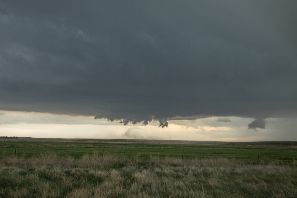
May 20th Akron, Colorado Tornado Warned Supercell
May 20th took us to eastern Colorado for what appeared to be a decent set up on paper. High based storms formed before moisture could work its way west, however they did not last. By later in the afternoon a storm developed rapidly southwest of Akron as a cluster of cumulus deepened. The storm hit the better air and became severe. Structure improved, and soon a lowering developed with RFD dirt wrapping around it. A merry go round ensued. The developing rotation could not tighten enough to produce a tornado, but it was fun watching it try. Lightning became intense so we had to vacate our position and move east and south. Eventually the storm became quite messy and we chose to leave it since we had to be in Iowa the next day on a far better set up (see the next chase account!!!). Enjoy the pics!

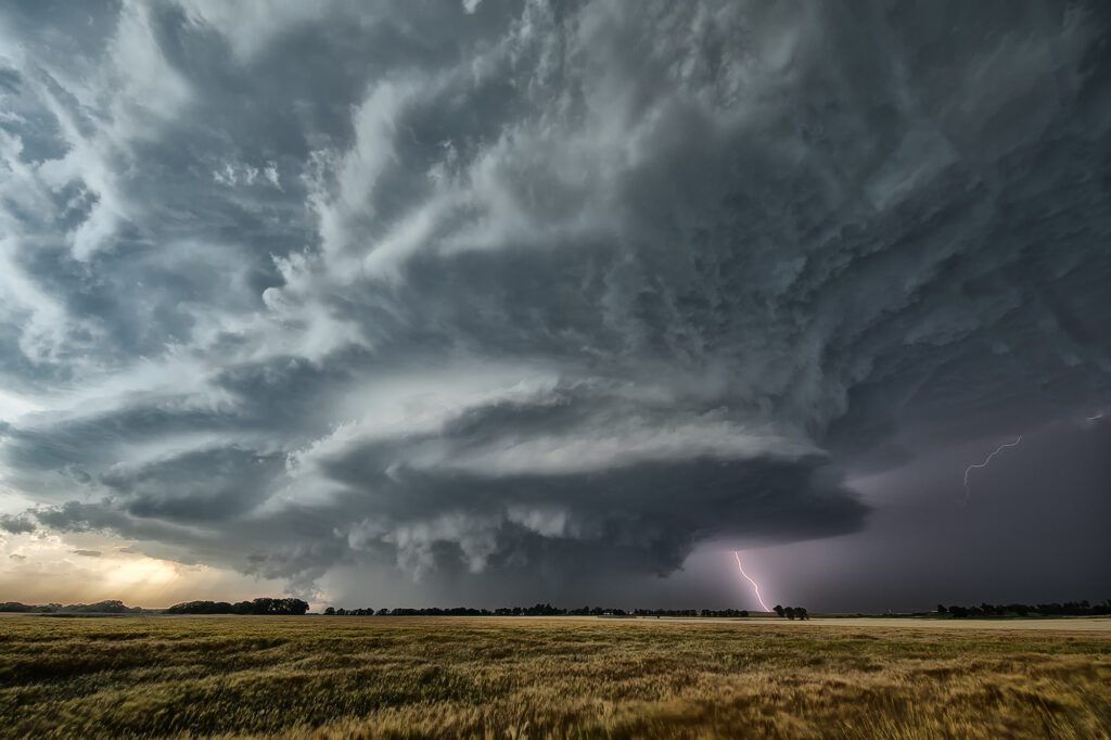
May 19th Butler, Oklahoma Tornadic Supercell
May 19th had a lot going for it. Good shear, instability and moisture, as well as a dryline in the eastern Texas panhandle set the stage for intense storms to form. By mid afternoon numerous storms formed and it wasn’t long before one updraft became dominant. Structure became quite good, and quickly a very slim tornado formed and disappeared in less than a minute. This just attested to the shear that was present. As the storm moved into Oklahoma, structure became amazing! A big soda can updraft with striations and a wall cloud were visible. As the storm approached Butler, it became tornadic and produced a cone tornado, near Custer City followed by w wedge north of Hydro. We got in intense RFD and had trees coming down around us, so we had to get out and move them ourselves so we could continue the chase. As we later past ElReno, we stopped at an exit and filmed the storm coming at us, complete with rapid rising and twisting scud, which soon a debris cloud appeared. We were trying to get through OKC and head north for the night and didn’t want to chase in the city as a substantial tornado touch down south of ElReno. Chasing at night is a challenge, but around a larger city, it is dangerous. We drove north to spend the night in Salina and get ready for the next day which would be a chase day. Enjoy the pics!
May 15th Ponca City, Oklahoma Supercell
May 15th featured a boundary across far southern Kansas into northern Oklahoma. Strong convergence, decent moisture and good shear would set the stage for supercells to form along it. By mid afternoon, storms did just that. One main supercell developed and right turned into northern Oklahoma. Structure was very nice and at one point it even produced a funnel halfway to the ground. The supercell was a prolific hail producer with stones falling as large as softballs. As it moved east, it eventually out ran the instability and weakened near dark. One of the prettier supercell of this year so far, and even though it didn’t produce a tornado, the guests loved it! Enjoy the pics!

May 11th Pecos, Texas LP Supercell
https://youtu.be/j6viBkgwuzgMay 11th was a tough one to gage severe potential. Plenty of outflow boundaries were around, and an advancing cold front as well. Shear was decent, but moisture and instability were scant. We positioned ourselves near Pecos, Texas and finally by late afternoon a supercell formed northwest of town and became severe. The drifted east spinning like crazy and was warned for golfball sized hail. As the sun set, the storm died as stability occurred as the diurnal cyclone ended. A fun chase and a cool time lapse can be found here:


May 8th Springfield, Tennessee Tornadic Supercell
May 8th had a lot going for it. Strong instability, good shear, high CAPE and several boundaries played into the end result. We caught several tornado warned supercell, including one near Springfield, TN that produced a cone tornado. Between slow, curving, winding roads, low speed limits and slow traffic, it made it difficult to get in front of storms. The Springfield supercell spun like crazy and produced a cone, causing damage. It took us what seemed like forever to get in front of it. As we broke through the core, we could see the cone tornado behind us in the distance. It had been on the ground over 10 minutes. As we got into a better position to see it (due to hills and trees!), it dissipated. We then blasted south to catch a supercell near Columbia, TN that showed signs of strong rotation and was tornado warned. As we approached Nashville, insane traffic slowed us down by 30 minutes. And of course the supercell produced a violent wedge tornado that became rain wrapped by the time we could get to it due to traffic. Frustrating day, but we DID see a tornado! Tennessee and Kentucky are extremely difficult to chase in!!!! Enjoy what pics we could get!