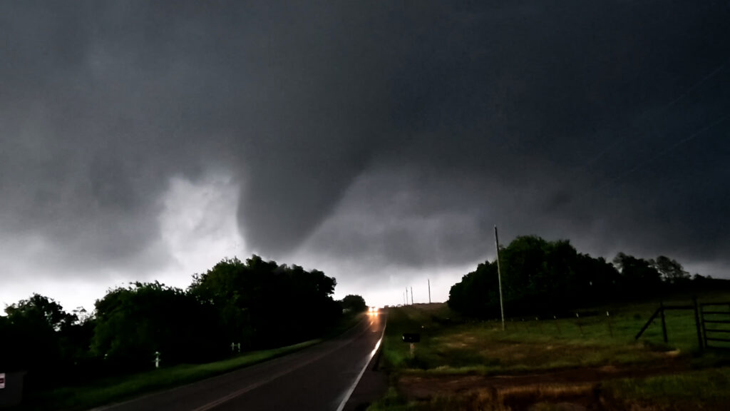
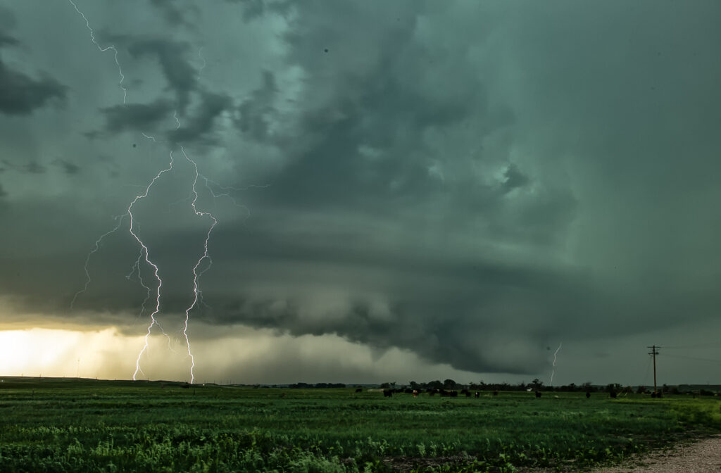
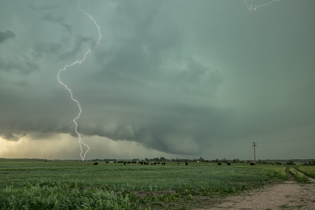
June 24th promised some intense supercells in Colorado and nature did not disappoint. Mid afternoon saw storms erupt on the south side of the Cheyenne Ridge north of Ft Morgan. These became severe and supercellular quickly, eventually resulting in a tornado warning south of Brush. As the supercells moved south, they encountered drier air and weakened. Then another storm formed on an outflow boundary north of Haxtun and became tornadic. Several tornado reports came in as we blasted north. When we got within 15 miles, you could make out the broad cone shaped funnel, but could not confirm touch down. As we got close, of course, the storm weakened. Other storms formed along the outflow boundary to our west and also became severe. Quite the sight at sunset watching the raging supercell with lightning strafing across the sky!

June 17th Illinois Tornadic Supercells
This day had big potential, but one huge problem. Unusually strong mid level winds would cause storms to move near 60 mph, more resembling March than June. Dual outflow boundaries would also wreak havoc on which one to chase, but it became clear the southern one would produce. Tornado warned storms on the northern boundary, would eventually move right and interact with the south boundary and that’s when they became tornadic. With highway alignment and speed limits not being our friend, it was extremely difficult to stay up with any storm. We intercepted 5 different storms that were tornado warned and a couple produced. We started the day near Springfield, IL and ended west of Effingham, IL, chasing like crazy. Fun day, so many close opportunities, so little rewards unless you were able to be in the right place at the right time.

April 25, 2026 Southeast Oklahoma Tornadic Supercell
Day 1 of the Close Encounters tour kept us very close to Oklahoma City. A warm front/dryline triple point was just south of town. Models show extreme instability developing during the afternoon, with isolated supercells forming. Mid afternoon we drifted to Sulfur as storms formed close by. As they moved east the weakened moving north of the warm front. Eventually one storm anchored on the boundary and started spinning. It produced and bog cone funnel that just could stay consolidated, and fell apart after a few minutes. Due to many storm interactions, we dropped south to the tail in cell near Mill Creek. As we arrived a tornado formed. We saw the debris cloud from a rock plant and were able to stop in time to take photos and videos. It was on the ground for about 5-6 minutes. This day was a ton of hard chasing but in the end we managed to see a tornado. Enjoy the pics!
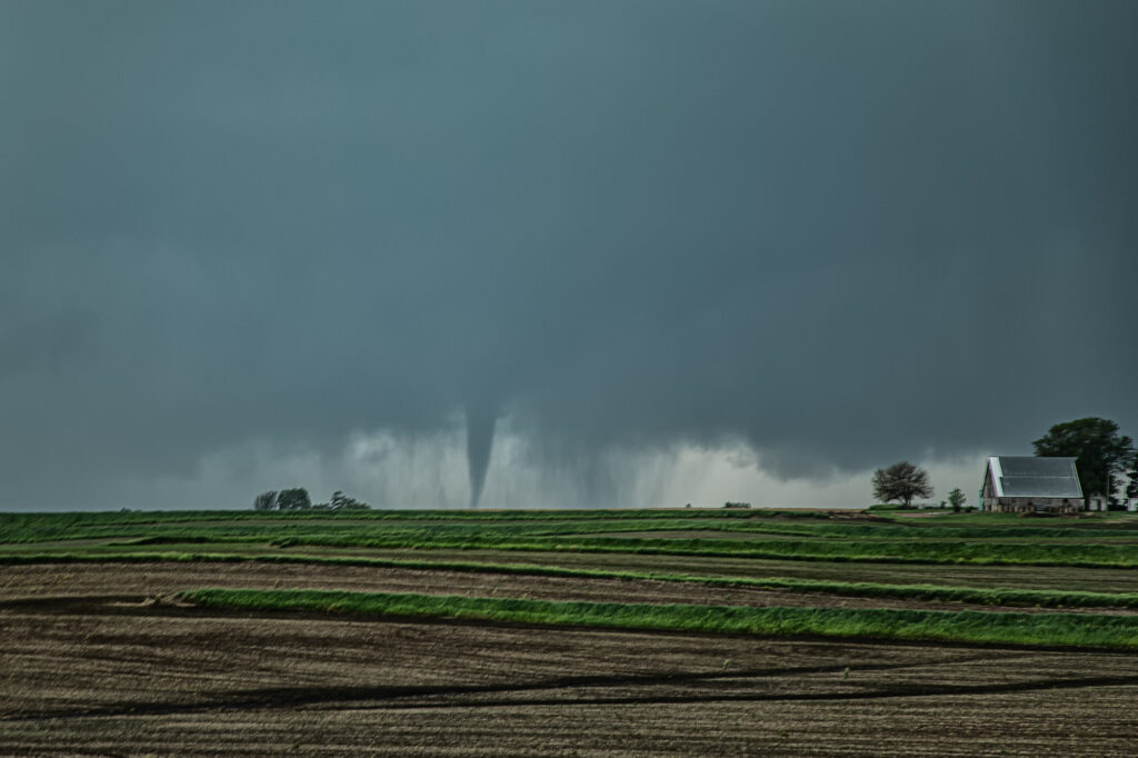
June 16th Dickens, Nebraska Once a Decade Tornado!!!!!!
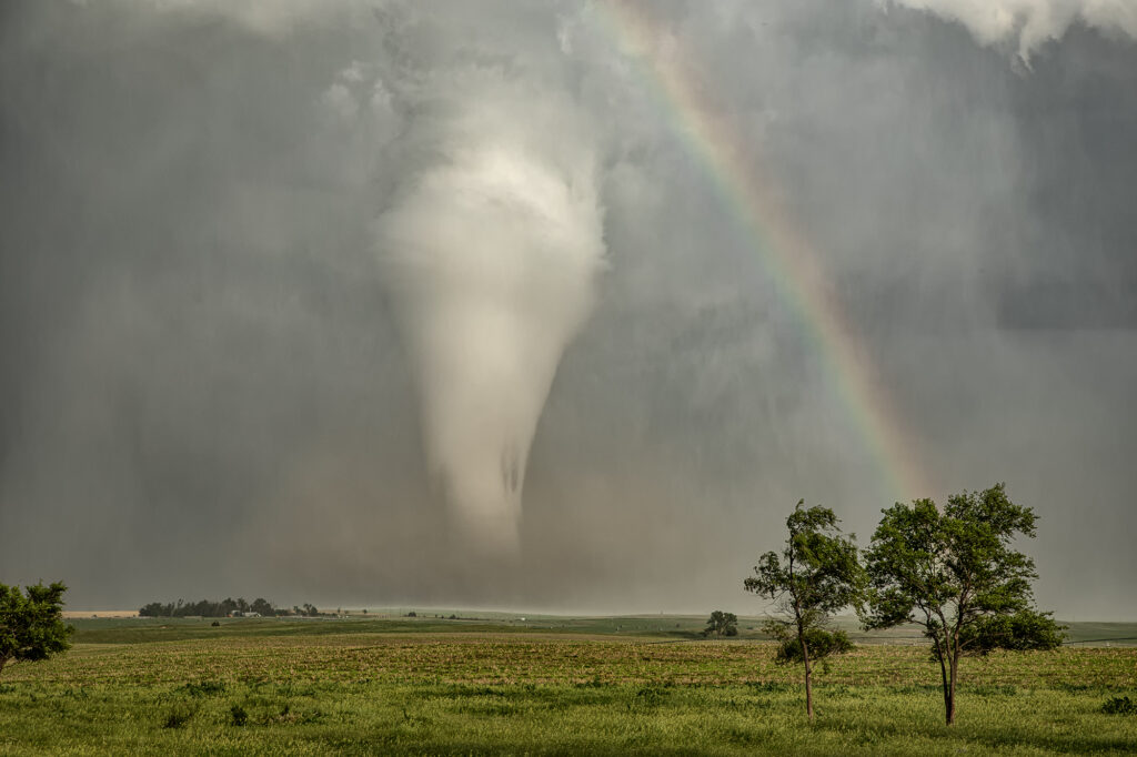
June 16th, a day that is now etched our my mind forever. Two targets were evident in the morning, the warm front in Minnesota and the front/theta e axis in Nebraska. Minnesota produced a few tornadoes, but nothing compared to the long lived photogenic beauty in Nebraska. After chasing in Montana the day before, we had a long drive to make Nebraska in time for storm initiation. Over 4000 CAPE, moderate shear and near 70 dewpoints present, we knew we had no time to waste! We blasted towards the target south of I-80 between Ogallala and North Platte, as we approached Lake McConaughy, strong updrafts started forming south of North Platte. We jumped on I-80 headed east as one updraft took over the show! It looked like a nuclear bomb had gone off! Within 20 minutes a tornado warning was issued and almost immediately a tornado was reported on the ground. This was a landspout that last 8 minutes. Soon after that a supercellular tornado formed, and firmly planted itself just east of Dickens. We were finally in a position to blast south on the back side of the supercell and could see this tornado 25 miles away! About 20 minutes later we arrived near Dickens as the tornado became a huge cone/stovepipe shaped tornado, barely moving! We sat up our cameras and camcorders and captured this 45 minute long EF2 tornado as is barely moved, only traveling 3 miles in it’s lifetime. Sitting up on a hill gave us a great view of the tornado and the sun lighting it almost white with a rainbow was a sight to behold! One of the prettiest tornadoes this decade! It eventually roped out, moving slowly southwest and tried a couple more times to produce. It was amazingly electrified during this phase as well, with a classic liberty bell shaped structure! A day we’ll never forget! Enjoy the pics!

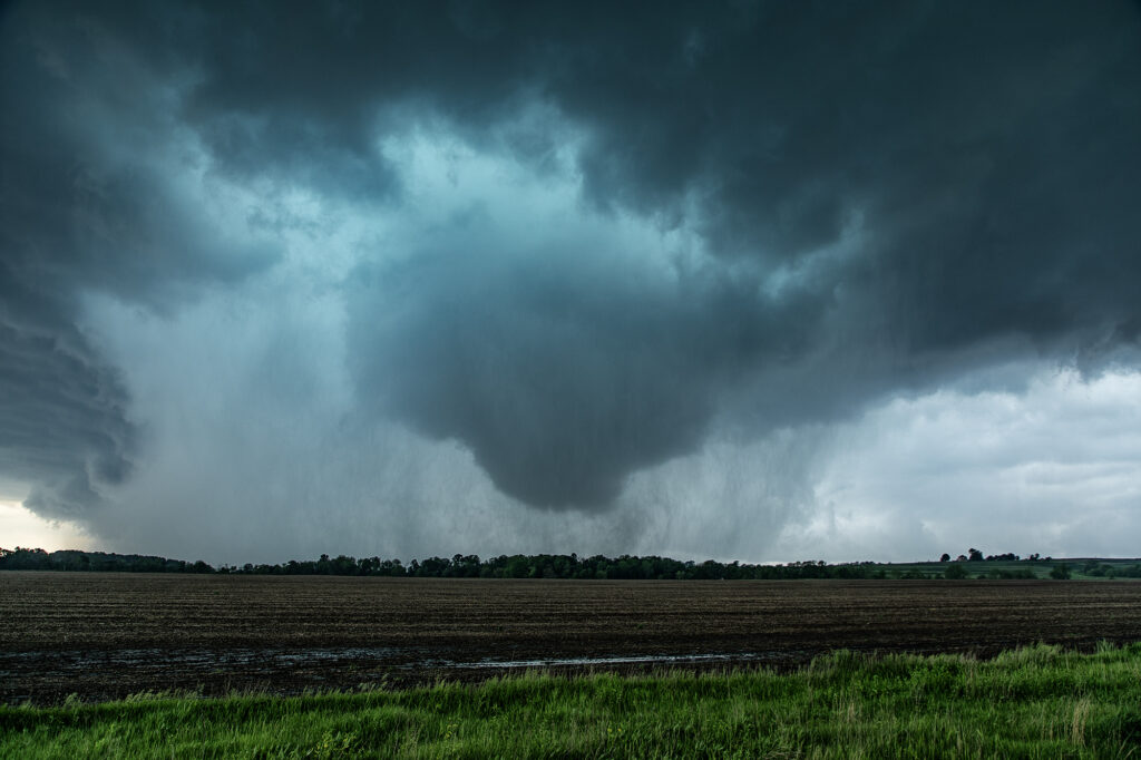
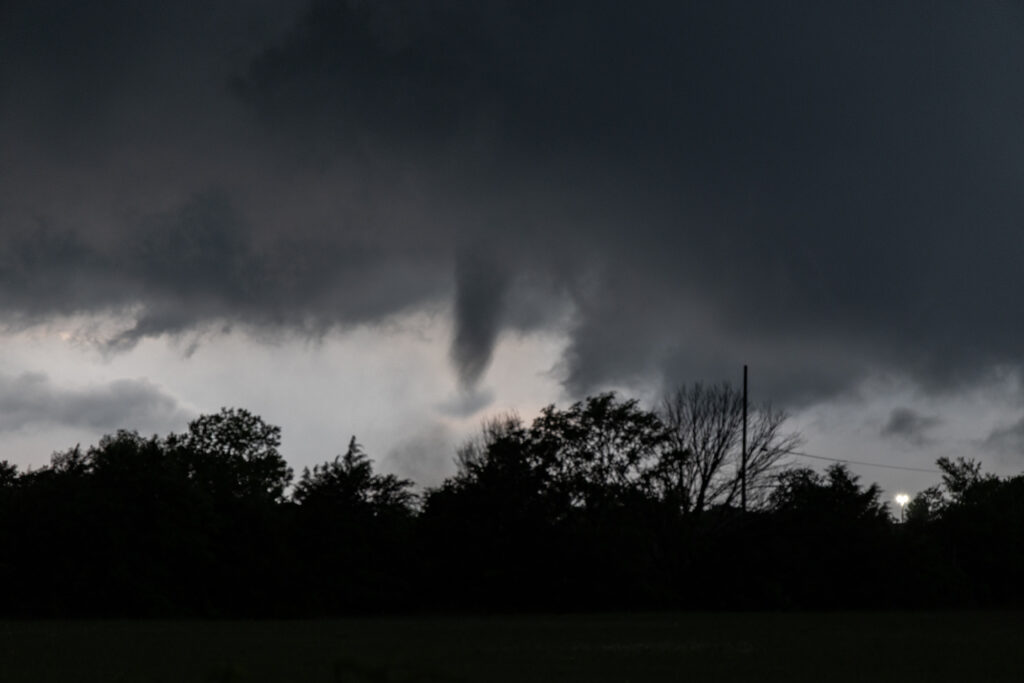
June 13th Potter, Nebraska Surprise Tornadic Supercell
June 13th looked poor on paper. Modest shear, moisture and CAPE along the Cheyenne Ridge between Colorado and Nebraska. We started west towards Cheyenne where moisture was really quite meager. Much better and deeper moisture and instability existed further east, from near Sidney, Nebraska eastward. Strong easterly winds were pushing that moisture westward, but it didn’t look like it would make it in time before storms collapsed. Outflow surge from Cheyenne storms blew east and when it interacted with that deeper moisture, a line of storms, some supercells, exploded. Near Potter, NE on I-80 an updraft anchored and spun hard. It became incredibly electrified! It also produced a 5 minute multivortex tornado before it produced a tapered truncated cone tornado right near the interstate. Staying down wind a few miles allowed us to get out of the intense lightning threat, but also limited the view we had. But we were able to see the tornado and structure of the supercell together. It was very nice! Quite the surprise ending to a marginal day. Once in awhile nature gives you those surprises! Enjoy the pics!
May 16th, Southeast Missouri Tornadofest
May 16th was advertised by SPC with a MODERATE RISK across the MS/OH river areas. It did not disappoint! Strong shear, high moisture and instability, and a slowly advancing front set the stage for what would be the most significant severe weather outbreak of the year so far. We started in Springfield, IL and blasted towards Sikeston, MO, which was my target. Storms formed west along the front and moved east and intensified. We decided to push west a bit and meet them as they came out of the Ozarks (a nearly impossible area to chase in!). As is often the case, we targeted the tail end storm, which typically gets the best feed of moisture, as it moved just north of Poplar Bluff. It had a great hook echo on radar and showed a strong velocity couplet. As it emerged onto the flat terrain, a truncated cone tornado formed and went on to be on the ground over 15 miles. It caused significant damage and was rated EF3. Another tornado formed just east of the first, a long slender elephant trunk shaped tornado, and ended up getting rated EF1. The supercell moved east across the Mississippi and Ohio rivers west of Paducah, and due to terrain and poor road networks, we couldn’t stay up with it.
More storms formed back west into southeast Missouri, so we pursued them. We caught up to them just west of Morley. An elephant trunk shaped funnel descended and touched down just west of town causing EF1 damage. Soon another EF1 tornado formed just to out northeast and eventually dissipated as it crossed the river. Numerous tornadoes occurred across this area during this event, causing extensive damage and unfortunately even loss of life. Our heartfelt sympathy goes out to those who suffered, including a tornado that directly hit St Louis. Please take the time to donate to local charities to help those impacted by these tornadoes and supercell thunderstorms.
April 24th, 2025 Matador, Texas Tornadic Supercell
What a day April 24th was!! There was a high threat for supercells and if one could latch on to a boundary in place it had the potential to produce tornadoes. Strong shear, great moisture for late April standards, and good instability were all present. I headed down from Woodward to the Texas Rolling Plains. When I arrived, a supercell had formed and started spinning hard not far from Silverton. As I approached it from the east at Turkey, I encountered baseball sized hail and dropped south to get out of it. I set up my camera and soon an elephant trunk shaped tornado formed. It planted firmly for about 10 minutes before dissipating. Soon the storm started reorganizing and I dropped south to just north of Matador. It cycled and developed a wall cloud, then a bowl and then a multivortex tornado. That turned into a huge cone, then close to a wedge before becoming rain wrapped. It was on the ground for probably 25-30 minutes!! After that the storm became quite HP and, having to be back in Oklahoma City that night, I left it and proceeded back to our base city. An amazing day, structure, 2 tornadoes, huge hail and lightning. Enjoy the pics!

April 19, 2025 Mertzon, Texas Tornado
April 19th was a long drive. Up at 4am to hit the road, we blasted nearly 700 miles, only to miss the best tornado of the day by 20 minutes. Talk about frustration! Models/NWS/SPC stated the tornado threat wouldn’t ramp up until after 6pm when the low level jet kicked in. All were wrong! Before 4pm a supercell hit the boundary and became tornadic. By the time we arrived, that storm had weakened so we targeted another supercell west/northwest of San Angelo. It also became briefly tornadic as the main meso wrapped up and dropped a cone funnel to the ground! It was only down a couple of minutes before lifting back up. A long drive, but we at least were able to capture a tornado!


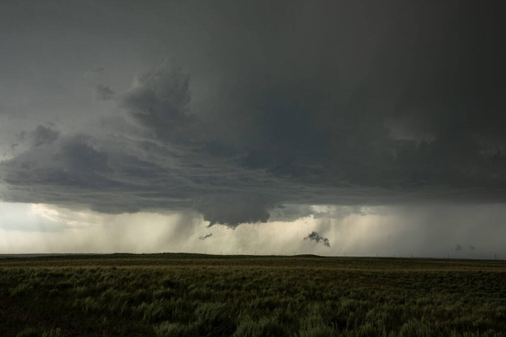
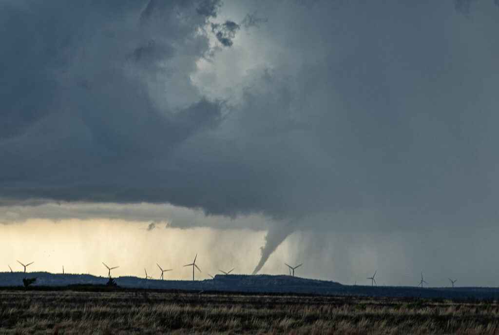
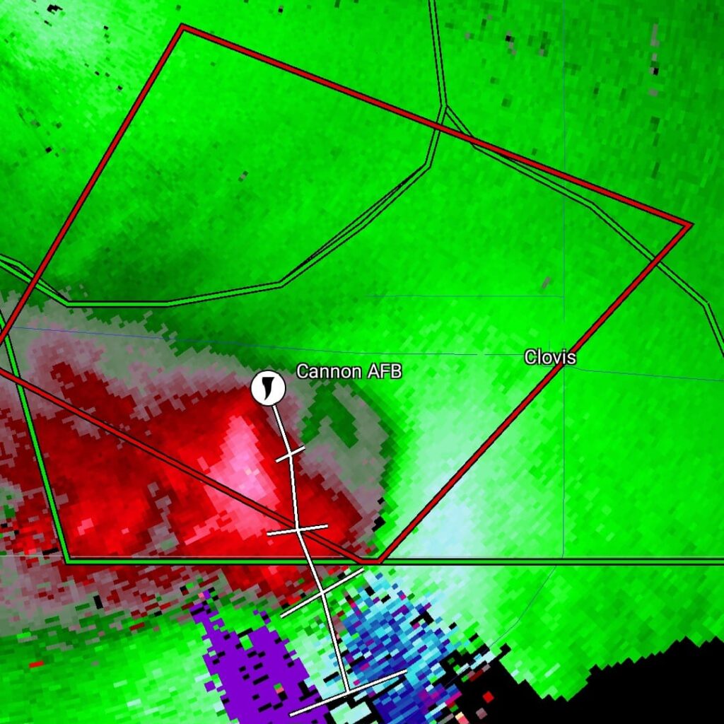
May 29th Clovis New Mexico Tornadic Supercell
May 29th was a marginal day at best. Southeast Colorado looked like the place to be. However, with moisture pooling along a boundary in east central New Mexico, I had a hunch that would produce decent supercells late in the day and evening. The Colorado target got interesting and produced a couple tornado warned storms ( See the previous chase account for the Prime Time Minitour!!!), but I chose to wait and see what would happen in New Mexico. I was not disappointed!!!! By early evening as a short wave trough approached, storms developed northwest of Clovis. It didn’t take long to see they were anchored and would start spinning quickly. As we approached the northeast side of Clovis, a tornado warning was issued. Numerous images from various locals and also my defunked video camera showed what appeared to be a cone tornado northwest of town. The NWS in ABQ is currently validating the tornado based on images, video and local chasers in the area. We nearly had the storm to ourselves, which is quite rare in this day and age!!!! We dropped through Clovis and ended up north of Portales, NM and sat and watched the storm spin like crazy. It was constantly tornado warned. The structure was absolutely top notch, even in the dark and hook after hook formed on this anchored supercell! Finally, by late evening, things started winding down, so we drove to Amarillo to our hotel for the night. One of the BEST structured supercells of 2024, even in the dark! Please enjoy the pics and NO they are not photoshopped!!!!

May 21st Southwest Iowa Tornado Outbreak
May 21st was a high potential set up in Iowa. A strong dry line, with fantastic shear, high CAPE and deep moisture would create a very dangerous environment in Iowa. By early afternoon storms exploded along the dry line and intensified as they moved east. Initial storms were not tornadic, but as the afternoon progressed, low level shear increased and tornadoes occurred with many storms! Our first tornado intercept was near Red Oak, Iowa as a supercell started spinning hard. The tornado went from a slender elephant trunk to a stovepipe and persisted for several minutes. The second tornado formed southwest of Carbon. It started as a big bowl, then vortices spun up and wrapping rain curtains were rotating violently around it. With motions of 60 mph we had to get out of its way as it approached us within a mile. The next tornado is now probably the most well-known. A strong multivortex tornado formed to our south near Corning and intensified as it moved northeast. It eventually turned into a raging F3 tornado that caused significant loss of property and life in the town of Greenfield. Our heartfelt sympathies go out to those who suffered losses there. Always the downside of significant tornadoes. Another tornado occurred to our southeast as a cell raced north towards Creston but we lost it due to storm motion and another core with huge hail causing us to have to slow down. Crazy, wild day that most will never forget.