June 16th, a day that is now etched our my mind forever. Two targets were evident in the morning, the warm front in Minnesota and the front/theta e axis in Nebraska. Minnesota produced a few tornadoes, but nothing compared to the long lived photogenic beauty in Nebraska. After chasing in Montana the day before, we had a long drive to make Nebraska in time for storm initiation. Over 4000 CAPE, moderate shear and near 70 dewpoints present, we knew we had no time to waste! We blasted towards the target south of I-80 between Ogallala and North Platte, as we approached Lake McConaughy, strong updrafts started forming south of North Platte. We jumped on I-80 headed east as one updraft took over the show! It looked like a nuclear bomb had gone off! Within 20 minutes a tornado warning was issued and almost immediately a tornado was reported on the ground. This was a landspout that last 8 minutes. Soon after that a supercellular tornado formed, and firmly planted itself just east of Dickens. We were finally in a position to blast south on the back side of the supercell and could see this tornado 25 miles away! About 20 minutes later we arrived near Dickens as the tornado became a huge cone/stovepipe shaped tornado, barely moving! We sat up our cameras and camcorders and captured this 45 minute long EF2 tornado as is barely moved, only traveling 3 miles in it’s lifetime. Sitting up on a hill gave us a great view of the tornado and the sun lighting it almost white with a rainbow was a sight to behold! One of the prettiest tornadoes this decade! It eventually roped out, moving slowly southwest and tried a couple more times to produce. It was amazingly electrified during this phase as well, with a classic liberty bell shaped structure! A day we’ll never forget! Enjoy the pics!


May 2nd Hawley, Texas Violent Tornado
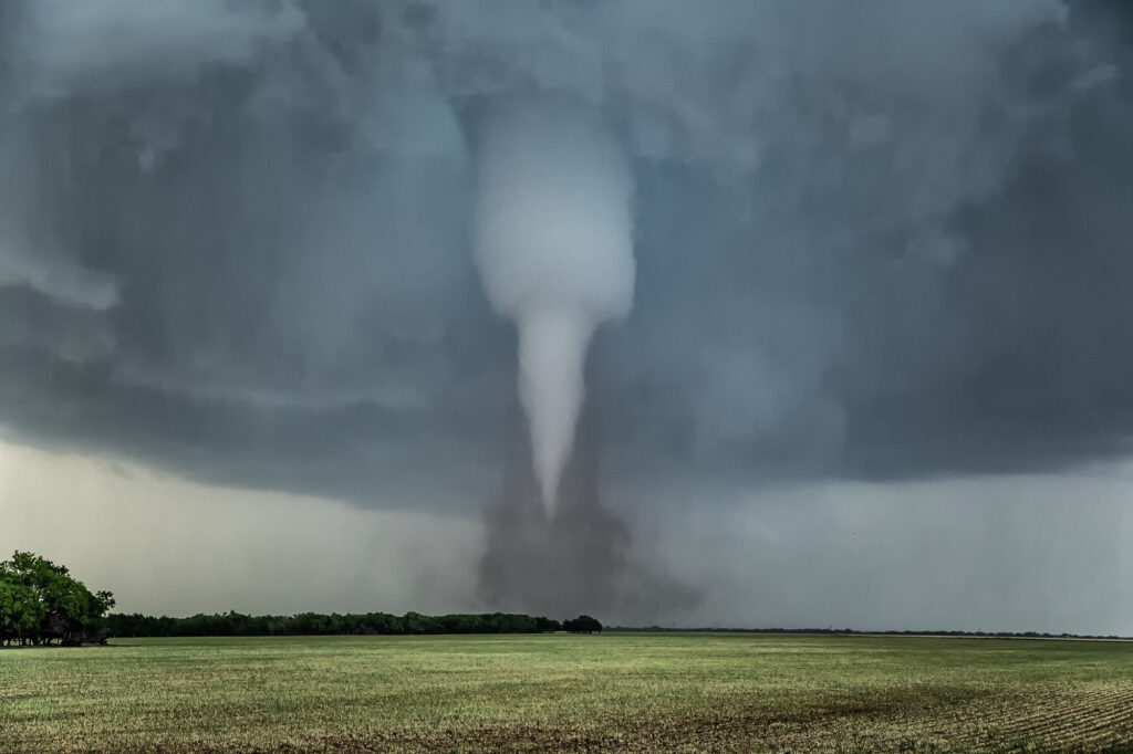
May 2nd featured a weak boundary in central Texas that would be the focus for storm development late in the day. Numerous storms formed along the boundary. Due to shear profiles, storm splits and mergers were evident. By mid to late afternoon a few storms formed along highway 277 north of Abilene, Texas. One split happened that passed in front of a right moving supercell near Anson and caused it to increase rotation rapidly. West of Anson a tornado touched down and was on the ground for a few minutes. As the old occluded mesocyclone weakened and dissipated, another one formed to the east/southeast of the first one. Soon rapid rotation occurred and eventually led to a small funnel. The funnel ascended and descended several times before it finally touched down northwest of Hawley. As the tornado firmly planted, a debris cloud formed. The tapered tornado widened into a text book drill press type tornado, with its strongest winds at ground level. The waterfall sound of the roar of the tornado was quite audible as it churned towards highway 277. Unfortunately it hit a couple houses, levelling them in its wake. The tornado then moved southeast and dissipated. All in all it was on the ground for over 20 minutes. The damage it causes was sporadic, but was rated high end EF3.
A great chase day, but with sad results due to the destruction the tornado caused. You NEVER want to see that happen anywhere. Fortunately the NWS in Abilene was able to give advanced warning to local residents, which resulted in no fatalities, but a few injuries did occur. Our thoughts and prayers to go to those families who were affected by this violent tornado.