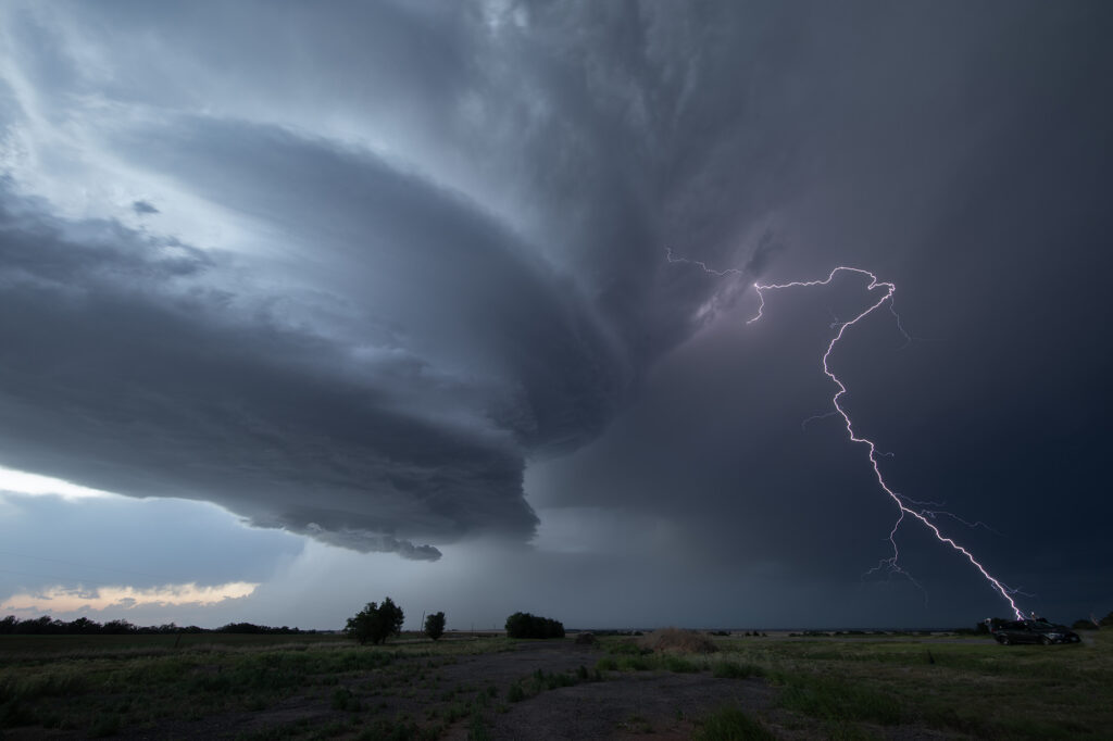
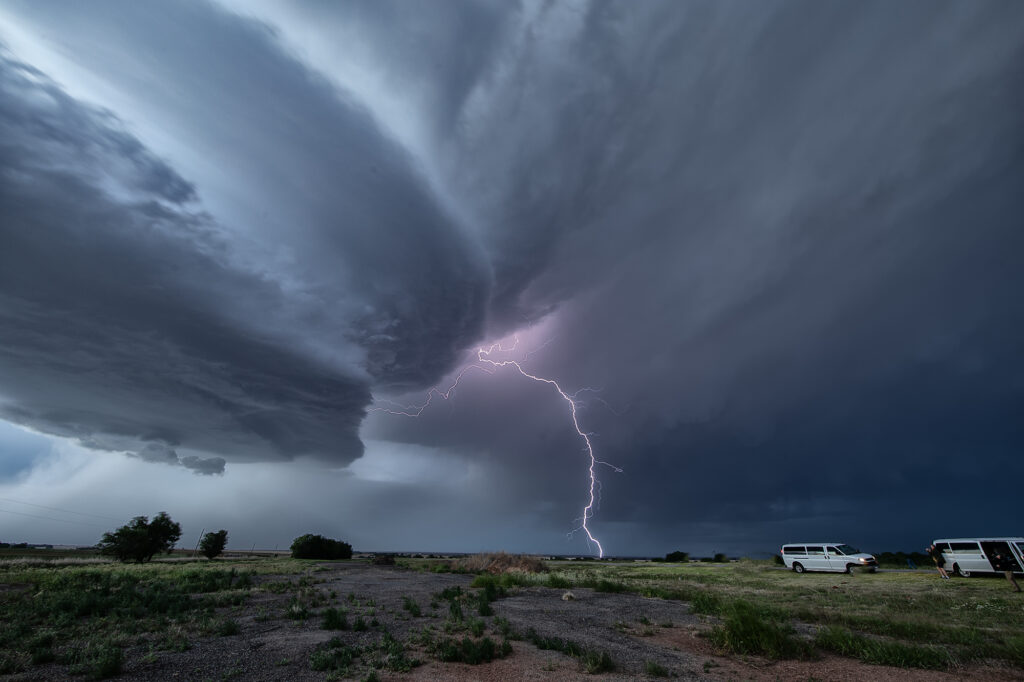
May 9th looked like a day where things just weren’t in sync. Good shear and lift were in place, but poor moisture with moderate CAPE were also in play. We targeted southwest Oklahoma where there was a bit higher moisture, however it was very thin. Storms blew up along a boundary near I-40 and became severe. They were fairly high based, but with good shear and steep lapse rates, they rained down hail to baseball size. We blasted north to catch the tail end storm as it moved into western Oklahoma. It hit the theta-e axis and rapidly strengthened. As it moved southeast towards us, structure steadily improved. We stayed with it till after sunset as it started producing copious amounts of CGs. Finally, it weakened around 10pm so we left and made it to the hotel before midnight. A great day with arguably the best structure of this young 2026 season! Enjoy the pics!!!
June 25th Whitman, Nebraska Incredible Supercell and Strong Tornado
June 25th had a lot going for it. Dewpoints in the 70s, an old outflow boundary, high CAPE and convergence would get storms exploding in the afternoon hours. We targeted a pair of severe storms west of O’Neill, NE and watched them intensify and move south. However the western most storm quickly died when it moved over the boundary and the second one also met the same fate. Meanwhile towards Norfolk a supercell became tornado warned and produced a brief tornado. I always watch trends in surface observations and satellite and noticed the boundary sharpening up and angling towards the northwest to the west of us. Moisture was rapidly increasing with dewpoints in Thedford, NE rising from the low 60s into the low 70s with strong easterly winds. Soon, a storm formed along the boundary northwest of Mullin and anchored for awhile. It steadily intensified as we blasted west. By the time we got to Thedford, the storm was strongly severe and we could see an impressive mammatus field under the anvil. As we continued westward to get a better view, the storm formed a strong couplet and a hook. Structure was starting to become visible as we approached Mullin. We continued west and soon were greeted with a magnificent sculpted supercell and a rapidly growing tornado! The tornado grew to an impressive cone, then wedge as it moved south towards the small town of Whitman. We stopped about 3 miles from it as it was getting ready to cross the road and continue southward where we had no south roads! Frustrating! The sight of both the supercell with large tornado under was the best I’d seen in 2024!! Just an amazing scene! We had to back track to Mullen and drop south so we could catch up to the supercell again. We would not see the updraft again in the daylight. As it approached North Platte, it weakened and eventually died. An absolute phenomenal day! Unfortunately the tornado hit a couple of houses near Whitman and caused significant damage and 1 injury. I shudder to think what could have happened if it hit the town directly!
Check out our Youtube video from the even here:
https://youtu.be/Zx9_R1aMxQ0


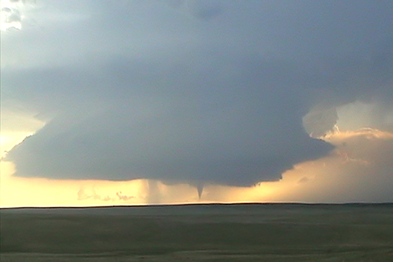
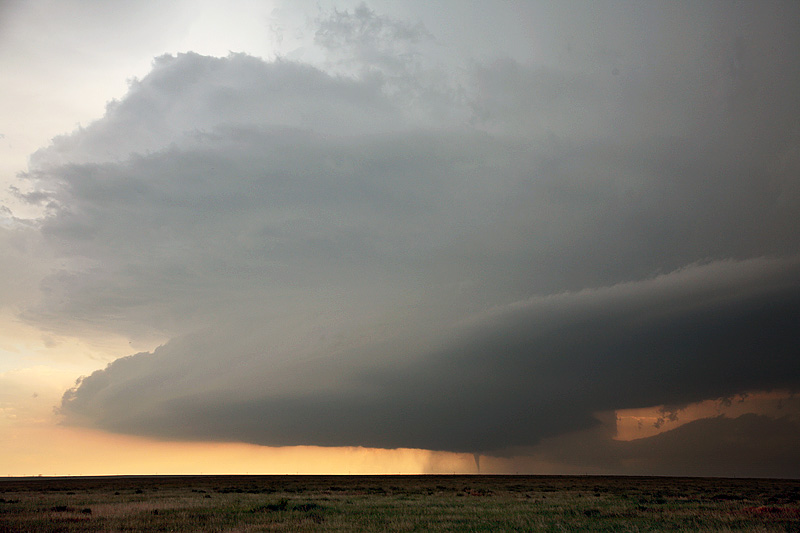
June 10, 2010 Last Chance, Colorado Tornadoes
June 10th had very good instability and moisture, and fairly decent shear. Upslope flow at the surface with moderate southwesterly flow aloft would set the stage for supercell development off the Palmer Divide and the Cheyenne Ridge in Colorado. We ended up a bit late to the Palmer Divide to chase the Last Chance storm due to a large tornado warned supercell near the Cheyenne Ridge northward, but we soon left it and made it in time to witness two tornadoes and gorgeous structure of the Last Chance supercell. Some of these images are digital stills and a few others are video grabs from Caryn’s camcorder.