Tag Archives | Missouri

May 10, 2014 – Orrick, Missouri Tornadoes

I must admit what happened this day was a bit of a surprise. Low level moisture was quite lacking, however, pooling along the warm front deepened the moisture and allowed cloud bases to come down a bit, low enough to produce at least 3 tornadoes we witnessed. Several storms exploded over the Kansas City area, and the tail end storm ended up riding the warm front east/southeast on the strong shear and temp/dewpoint gradient. It became tornadic near Orrick, as an EF2 tornado unfortunately hit town. We also witnessed a brief elephant trunk and a larger cone/wedge looking tornado east of there. Fortunately there were no fatalities with any of the tornadoes.


May 22nd, 2011 Joplin, MO Devastating EF5

2011-joplin-mo

May 22nd, 2011 was a day I will never ever forget. It was one of the most horrific experiences I have ever had chasing. One engrained deep into my mind for the rest of my life. Some decisions we made this day saved our lives. To be within 5 blocks of one of the most devastating tornadoes in US history and to be able to write about is not something I take lightly.

We started in Wichita, KS, expecting a big day in southeastern Kansas and southwest Missouri. Our initial target was an Independence to Joplin line. Things looked good early with ample moisture, high CAPE, and good surface winds. I was afraid of the weak upper level flow not venting precip far enough downwind to keep storms from being HP and quite messy, and in the end, this was exactly what got us in trouble.

The first storms went up near Independence, KS and were quite explosive. They turned into a pile of outflow dominant cores quickly and were impossible to chase. These highly electrified cores were fun to watch as the CGs bounced around but updrafts never looked like they were ready to drop a tornado. Just too much outflow out of control, and too HPish.

As we moved from storm to storm, we continued eastbound towards the Missouri border as outflow spewed south of us. We knew we had to get back south and east of the OFB or we were in for a long evening. Storms would develop on the dryline to our south and move northeast, crossing the boundary, spin, become undercut and weaken. We chased a number of these cores, slowly moving east through the towns of Rosewood, Columbus, and Cherokee and into Missouri.

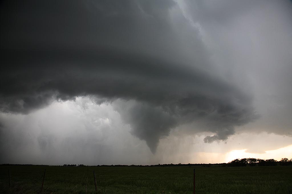
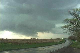
As we continued into Missouri, northwest of Joplin, one storm interacted with the boundary, developed a well shaped wall cloud, and became tornado warned. It pummeled us with large hail golf ball/tennis ball sized, but also crossed into the cold air and weakened. This was the first storm that became tornado warned in Joplin.

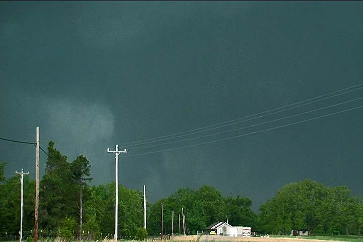
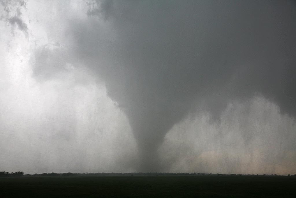
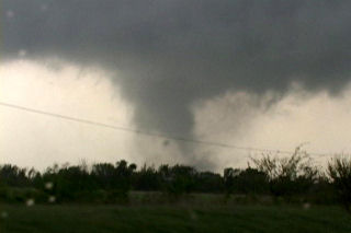
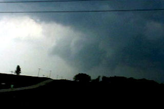
What happened next occurred at a time we were not really chasing, but with our guards up at all times, as one should. We came southeast into town and dropped south on Range line Road, (71Business) not aware of what was soon to happen to our west. A storm was developing on the dryline and started spinning before it hit the OFB. As it hit the boundary it became violently tornadic in 15 minutes! The rest is a historical section in US tornado events.  This storm turned hard right along the rolling spinning outflow boundary and quickly developed supercellular features and was extremely wet. HP storms are not fun to maneuver around as you cannot see what is going on under the mesocyclone.

Before this, we headed down Bus 71 and found a gas station to stop and refuel, and those who really needed to use the facilities were allowed out as it had been a long while since we’d taken a break. Fortunately as it happened, the attendants at the store would neither allow folks in, nor allow us to pump gas, because we were under a tornado warning from the storm that had already crossed the boundary and moved into cold air.  We pondered where we could use restrooms and decided to get back into the vans and head south looking for another stop. At that point I looked at the latest radar update and the storm now had a violent hook on it. I knew we had to act and act fast! I was pretty certain there was a tornado coming at us and at a steady pace, but had NO idea how significant this tornado was.

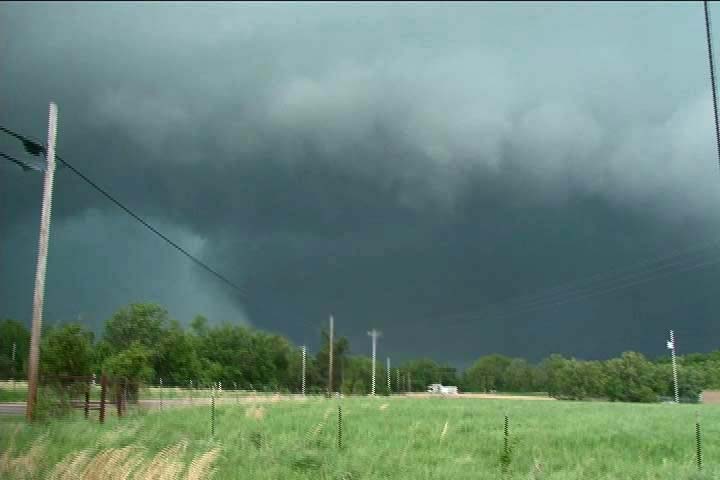
As we continued south on Range line Road, power flashes were seen to our immediate west, only 1-2 miles away. I knew we had to do whatever we could to get out of the way and NOW! We were 2-3 miles north of I-44 and I knew we had to get there, then head east and drop south on 71 to get out of the way forever! Very heavy traffic was on the road, and traffic lights every block, so progress was very slow and the situation became more and more intense.  As we progressed south, we started yelling at people to take shelter. They would point and laugh at us as we continued steadily south. I was concerned about folks at the many fast food places IN LINE to order at the drive through lanes, totally unaware of the approaching tornado. We honked, yelled, did whatever we could to inform people of the approaching danger. One guide called out to take shelter under the Home Depot covering, but looking up at the black spinning mass approaching I knew that was not an option. The Home Depot was totally destroyed with fatalities inside.

It was beginning to look like we were in big trouble when suddenly the power went out, including the traffic lights. We were moving again! We started weaving around traffic and charging towards the on ramp only a few hundred yards or so away. Just to our west, you could see wrapping rain curtains around the tornado as they hit us with 60-70 mph winds and pieces of debris falling on the vans. We knew we were in huge trouble if we couldn’t get to the on ramp that seemed miles away. The eastern edge of the tornado was getting close now!!!!! We had to head east/northeast on I-44 to get to 71 south, and that was the exact path the tornado was moving in! People were driving slow with the intense wind and rain/debris, and we had to weave around them to get east and fast. We made it to 71 south and blasted 5-6 miles south until we were clearly out of the way.  Many tractor trailers were flipped and destroyed on the Interstate just up the road just seconds after we got out of the way.

Our entire tour, including the guides, were pretty shook up by what had just happened. We had no idea how intense this tornado was and found out later just how strong it indeed was, an EF5. Only after stopping for a few minutes did we start hearing reports of heavy damage and as we headed south we noted many emergency vehicles heading north towards Joplin. It would be well into the evening before we understood the true magnitude of the disaster that had occurred.

As Rich Hamel stated (and I borrowed some of his content here!), in hindsight, three seemingly random events might well have saved us:

  1. The gas station refusing us service. If they had, we very likely would have stayed north of the tornado.
  2. The decision not to shelter at Home Depot. As stated above, the Home Depot was completely destroyed.
  3. The power going out, taking the traffic lights down. If not, I’m not sure we could have gotten moving fast enough to get out.

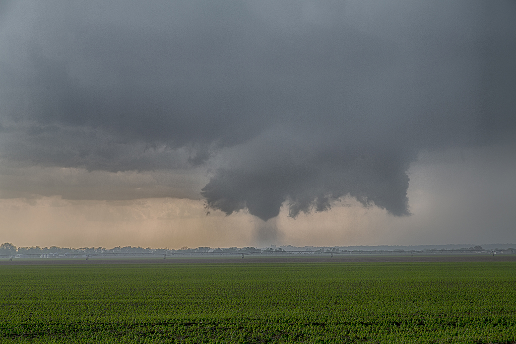
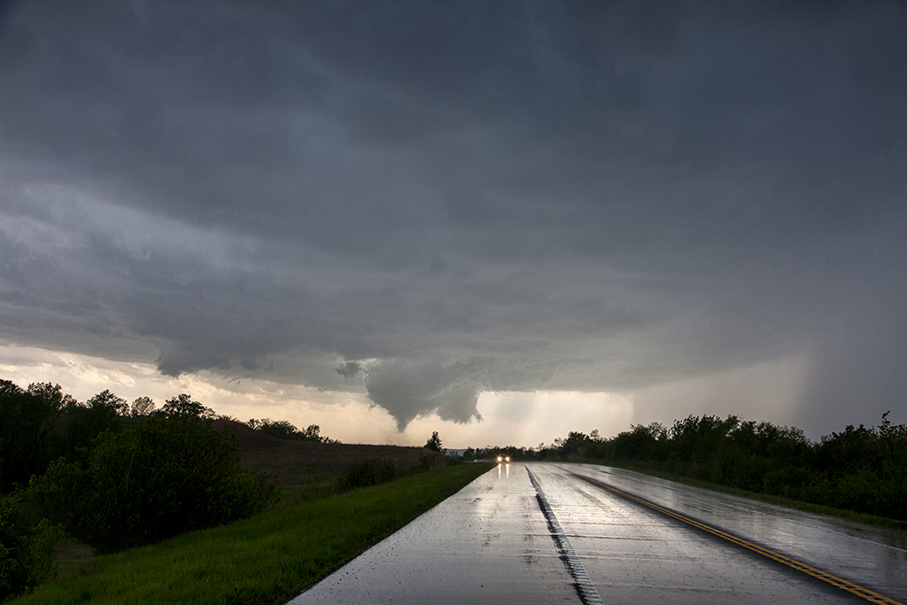
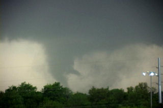
We drove south and intercepted another tornado in its late stages near Southwest City, MO as the tornado moved away through the trees and debris was falling, and then continued south to Siloam Springs, AR to head west to our destination for the night in Tulsa. As we headed west from Siloam Springs, a stout stovepipe became illuminated by lightning as it crossed the highway in front of us. Debris was strewn all over with pieces of insulation, sheet metal and chunks of woods all over the highway as we maneuvered around it.

We finally called it a night after that, but had one more surprise in store. As we entered Tulsa where our hotel for the night was, we ran into a big hail core from another storm that had just popped up to the southwest. It was on top of us before we knew it and soon we were getting hammered with huge hail! We witnessed two hail stones of at least tennis ball size slam into my windshield, which literally bowed with the force but somehow did not shatter! Then off to our left KABOOM! A bright blue flash and the power went out over the entire southern part of Tulsa. A power main must have been damaged by hail is all we can guess, but of course with everyone jittery from Joplin, people were worried about a rain-wrapped tornado. In only a few seconds, the power was back on and we finally got to the hotel, ending a long, dramatic chase day.

Thanks Rich Hamel for your account and SUPERB driving this day. Thanks to all SLT guides, Tom Howley, Andrew Gardiner and Matt Jones for your steadfastness in getting us out of a horrendous situation.

(NOTE THS CHASE ACCOUNT HAS BEEN EDITED TO CLARIFY THE EVENTS OF THIS DAY.)

Here is a map from Rich that shows the path we drove to get through Joplin, along with the tornado’s path.

247842_10150211169194386_737974385_6794026_5766282_n

Here’s a shot of the Siloam Springs, Arkansas tornado courtesy of tour guest Justin Noonan:

SONY DSC

April 30, 2010 Ozark County, Missouri Tornadoes

April 30th took me to southwest Missouri for what ended up being a High Risk day from SPC. All the ingredients were coming together for a tornado outbreak in Missouri and Arkansas. We targeted a pinch point in the boundary that occurred near Muskogee, Oklahoma. Storms kept firing in that location and then raced north into colder rain cooled air in southwest Missouri. Finally, one storm was able to right turn and not race into the colder air. This storm produced several confirmed tornadoes in northwest Arkansas and southwest Missouri as it pulled the boundary into it. We intercepted two of those tornadoes. If you have never chased in the Ozarks before, it is a very difficult task. With storm motion at 50 MPH, we were on curvy, winding, hilly roads that you could not drive over about 40 mph safely on. Thus as the storm passed us we could never catch it again. Below are a few pics and also a video I shot. Still it was an exciting successful chase!

May 13, 2009 Kay County, Oklahoma Tornado

May 13th took us to the Kansas/Oklahoma border. Our initial target was north central Missouri but due to a late night in northwest Texas, it wasn’t going to happen. We positioned ourselves north of near Blackwell and watched as numerous cells developed on the front until finally a decent supercell formed just to our west. It quickly started rotating and produced a very nice tornado that was on the ground for over 15 minutes. Please click on the video link for a neat 2 minute video and click on the photos for a larger image of this very pretty and well structured tornado.

May 4th, 2003 Pierce City, MO Long-tracked Tornado

Unbelievable day in the southeastern plains today! We began the day in OKC, determined to consider playing the tail end of this system. My concern (in addition to storm motion) was that the best show might occur in a narrow and early window over SC-E Nebraska (16-19Z) and then it would be over. Upon waking and looking at the data, it became apparent that the setup was indeed outbreak-like and that therefore one could likely pick about any storm and expect to see large tornadoes. Analysis soon suggested that the cap would break explosively in the HCRs ( horizontal convective rolls – bands of congested cumulus from which the most important storms of the day often develop; these bands are generally oriented along the low-level shear vector ) embedded within the highly unstable, strongly sheared warm sector. Stopping in El Dorado for fuel we watched as our surface winds slowly veered and our dewpoint spiked lower. Surface analysis revealed an intense low-level dry punch surging inexorably eastward towards SE KS and NE OK. I couldn’t believe it when I downloaded the SPC STOR and saw the 8-11 values blanketing the entire risk area from SE NE to N TX.

We decided on the spot to target SE KS, first intercepting storms on the northern portion of the E KS theta-e tongue and then dropping southward on different storms. We drove east on Hwy 54 to Iola and then north on 169 to Welda, KS where we sat for close to an hour watching convective towers get shredded to bits. Radar downloads revealed an intensifying cell moving NE towards the area south of CNU; rather than jumping on that as soon as we saw the first reflectivity core in NE Osage County, Oklahoma we sat watching convective towers closer to us. However, as the cell slowly matured and moved into Chautauqa Co. (see the radar downloaded via cell phone at the time, shown in Fig. 6 below), we could no longer sit still as we became convinced that this storm would become a prolific tornado producer. Driving south and then navigating around the NE side of CNU, we dropped SE in a desperate attempt to get ahead of this incredible storm (radar shot at the time, Fig. 7). As we passed the junction of Hwy 57/59 driving south on Hwy 59, we drooled at the spectacle of the rock hard convective bomb to our ESE. Following the western edge of the updraft down to cloud base, we immediately spotted a classic stovepipe tornado spewing debris about 7-8 miles to our E, somewhere near or just east of the Neosho wildlife area. Cursing at our failure to jump right on this storm as quickly as we noticed it on radar, we drove east on 160 out of Parsons, quickly taking up the rear of a very long and very sloooow moving caravan of storm chasers. We busted north and east on Hwy 126 intending to eventually intercept the classic tornadic supercell east of Girard, KS at or near the MO border. I gasped at the radar depiction of the storm’s hook overtaking Girard and wondered what kind of devastation was in store for towns east of this storm.

We were making great time and might have actually outflanked the storm as planned. However, fresh radar downloads revealed a very good looking tail end storm in Nowata Co. OK and we became convinced that this storm would eventually go on to produce significant tornadoes provided the dreaded 80-mph left mover to its SSE didn’t interfere too badly (this bit of bad luck killed what might have been a strong tornadic storm the day before near Childress, TX). On the way south to intercept the OK storm, we quickly detoured to check out the updraft base of another supercell moving NE through Labette Co., KS and quickly spotted a truncated cone tornado emanating from cloud base to our distant west. The storm started to look a bit more organized shortly afterwards and we pressed south, worrying that the Labette Co. storm would be interfered with by the tail end Charlie and would too seriously detract us from intercepting the southern storm. Driving through scattered golf ball -sized hail in the FF core, we observed the updraft (completely separated from FF core) and immediately noticed a fat, nubby funnel cloud just NE of Fairland, OK (we later learned that this was a weak tornado but couldn’t see the ground-based circulation for all of the trees and hills). Soon thereafter, the storm became rather disorganized as it merged with the left mover. Nonetheless, we persisted chasing this storm noting that inflow was still quite strong and moist southeast of the RF gust front . The storm began to intensify and take on scary HP/classic hybrid characteristics east of Neosho (which was devastated by a tornado on 4/24/75). Racing east on Hwy 86, we attempted to get to Hwy 60 north of Newtonia but the storm’s horrendous looking rear-flank core soon overtook the road before we got there and, fearing very large hail and powerful winds, we turned around and continued E and SE on Hwy 86, eventually turning north on Hwy 37 at the town of Purdy.

All this time, we were experiencing the storm’s ambient inflow which was 76/66 on 1725 winds. A new radar download revealed that this storm had retained classic supercell character with a vengeance and we wasted no time at all getting north to Monett , MO. The clefted -out barrel-shaped meso of an incredible beefy tornadic storm revealed itself to us soon after turning north out of Purdy and, 1 mile south of Monett , we observed a very large strong/violent tornado just northeast of town. We turned east on 60 and for the next 35-40 minutes experienced one of the most thrilling and fascinating tornadic experiences I’ve had. We watched in amazement as this fat, inky black-blue tornado rampaged across the countryside between Monett and Verona, spewing huge plumes of dirt/debris skyward. The tornado morphed into a fabulously fluid and dynamic multiple vortex tornado with evolutions that are best viewed on video rather than described. We got closer and closer to this high-contrast, long-lived tornado, watching as it lofted debris into cloud base and fearing for all in its path. I relayed reports to people with access to NWS numbers the best I could. I fear the tornado hit the north side of Aurora, MO. At times we got as close as 2/3 of a mile from the tornado as we drove northeast on Hwy 60 and then east on farm road 2200 south of Marionville and then Hwy 173 east of town. We got farther south of the tornado than we would have liked by this time (after being so close for so very long) but we got view of it again beneath the center of the incredible ground-dragging, clefted mesocyclone SW of Springfield: now it was an intense looking high-contrast stovepipe tornado with a fan-shaped debris cloud near Battlefield, MO. We watched as the tornado endured a classic rope-out on the west side of SGF, sparing the fortunate citizens of that city a bad tornado disaster.


April 30th, 2003 Northwest Missouri Supercell & Funnel

OKC at 7:30, we made our way to Topeka, KS. My optimism regarding the potential for visible tornadoes had evaporated the evening before due to the upper-tropospheric wave responsible for surface cyclogenesis being progged to fill/weaken rapidly due to stretching deformation (a tendency apparently underestimated rather badly by most models 2-3 days prior to the event). Nonetheless, we were optimistic about the likelihood of HP supercell thunderstorms initiating along the frontal boundary from NE KS to S IA/N MO. The focus of our afternoon data analysis was on finding the likely initiation point and best environment for daytime supercells; NE KS to S IA is an unacceptably large target area when storm motion vectors are going to be 35-40 kt. We became convinced that initiation would be near Falls City, NE with rapid intensification and maturation of supercells across extreme NW MO. Our mistake was that we didn’t have enough confidence in this to set up shop downstream of the expected initiation point – there have been many times when I overshoot the area of initiation and have to backtrack westward.

We moved north from TOP on Hwy 75 at about 4pm CDT, observing congested (albeit mushy) CU and TCU to our NW through E. At the Hwy 36 junction we observed glaciated convective towers to our not too distant N and NNE; additionally, the developing congestus N through NW was being visibly undercut by scud apparently associated with the leading edge of the cold front, so we continued on eventually crossing into MO east of Falls City. When we turned north on Hwy 59 in east-central Holt county we could make out much cloud base structure associated with our target supercell. We observed a well-defined dry slot with developing RFD gust front; to the NE of that was a very ominous block-shaped lowering/wall cloud that definitely had a tornadic appearance. We were too far to discern any detail. We continued stair-stepping N and E and when we were just east of Maitland on CR A we observed a fully occluded wall cloud with truncated cone shaped funnel cloud about 4-5 miles NNW of our location; the wall cloud and accessory scud tags were wildly rotating and I estimate its location to have been close to the town of Skidmore; I don’t remember the exact time (too busy navigating to keep a log) but it was probably around 6-6:15pm and we were too distant to confirm/deny that the funnel cloud was actually a tornado. I would not be surprised if a large tornado occurred somewhere N or W of Skidmore.

Unfortunately, we had been effectively outflanked by the storm so could not achieve the desired position due E or ENE of the meso. New mesocyclogenesis was rapidly underway to our immediate ENE and the RFD gust front was loaded with vorticity and wild, fluid vertical motion. Soon thereafter, the storm tended more to HP characteristics and developed a menacing rear-flank core with encircling shelf cloud. However, it refused to give up on trying to develop a forward flank updraft/meso as inflow stratus continued to fly into the storm from the E and SE and scud rose and attached to cloud base at the E edge of the core. East of Conception Junction in eastern Nodaway County we were briefly overtaken by the southern edge of a tightly circular precip curtain, the apparent center of low-level circulation passing just to our north. Our winds turned from SSE to W, gusting to near 50 kt. We finally got to the junction of US Hwy 169 and CR O at Gentry. The storm was now decidedly HP in character with a substantial surging RFD core/gust front bearing down on us from the SW and a less menacing FF core to the NW; we were sitting in the notch at this crucial intersection with no more east option. To our immediate SW and almost overhead a patch of cloud base was swirling wildly as the RFD core pivoted around from the W and SW to overtake us.

The rotating cloud base moved quickly to our east across open pastures near Gentry, MO and we were forced north into the SW edge of the FF core, letting the more dangerous RFD core pass to our SE. After the maelstrom passed we once again attempted to outflank the storm but decided to blow it off at I-35 in favor of targeting a more isolated storm SE of STJ. Downloading radar as we drove (my goodness gracious, I never failed to get a wonderful cell phone connection yesterday), we headed directly to I-35 exit 40 at Lathrop. Too late (we heard the warming for the spotter-indicated tornado near Edgerton); it was an interesting looking soda can LP storm (we got 1″ diameter in the vault and cars were briefly blocking the interstate at an underpass) with an amusing array of sheriff deputies and other gawkers staring up at the sky. On the way south, we were mightily distracted by a ridiculously explosive convective bomb forming over STJ. As we drove south on the interstate we watched as the fat convective tower expanded, grew, overturned and went crazy. We turned around at Lathrop and stopped west of Cameron on Hwy 36 for a very entertaining lightning show (great anvil crawlers in the vault/overhead anvil). Stayed around until the storm lost supercellular characteristics and lined out.