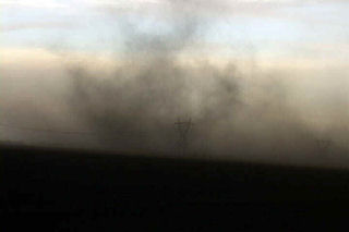
I must admit, this day caught me by surprise. We started in eastern South Dakota. After morning analysis and looking at model data, it appeared to be a respectable chance for large supercells in eastern Kansas with extreme instability and decent shear. As we arrived in Jefferson county, Kansas a supercell exploded from a small cumulus tower. Within 20 minutes the top was at 60,000 feet. Within another 30 minutes a tornado formed. This tornado narrowly missed the town of Oskaloosa.
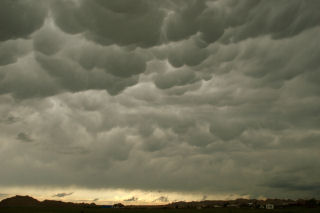
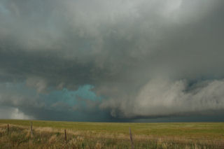
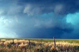
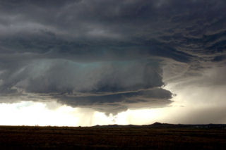
June 7th, 2005 South Dakota Badlands Supercell & Tornado
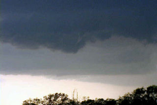
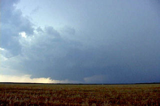
June 7 looked like a big tornado day in South Dakota. By the end of the day, it would be disappointing from the aspect, but the supercell I caught that day was special. The structure was phenomenal!!! This storm formed on the western end of the Badlands, and slowly tracked east/northeast towards I-90. This storm produced at least 1 tornado, and hail to 3″ in diameter. The prettiest part about this supercell was the structure.
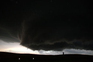
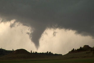
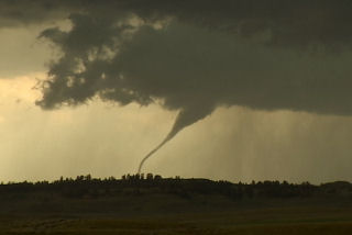
June 6th, 2005 Ekalaka, Montana Tornadic Supercell
What an interesting day this turned out to be. We started in Gillette, WY, blasted to Ekalaka, MT and sat north of town and waited, and waited and waited 🙂 Finally a high based little LP updraft developed, as usual, and was severe warned. The interesting thing with this is it was feeding on 72/56 air. It moved north and weakened. Then another storm RAPIDLY developed and intensified, southwest of town. This storm became a BEAUTIFUL striated stack of plates supercell, and quickly developed a nice wall cloud. Condensation streamed in from the northeast and soon a lowering was observed almost to the ground. Rotation developed and a funnel formed AWAY from the wall cloud. It extended a third of the way to the ground and dissipated.
Then a second funnel formed without being connected to the base, then developed a debris cloud and connected to the base!! Bizarre tornado! It stayed on the ground maybe 2 minutes and dissipated too. A third funnel formed and became a gorgeous elephant trunk tornado with INTENSE rotation and cascading motion in the cloud base. This also lasted 2-3 minutes. It also was rotating around the outer edge of the meso. A fourth funnel formed, a truncated cone, and became tornadic too with a debris cloud. This one lasted at least 5-6 minutes before dissipating. Eventually the lowering wrapped in rain, and then the rain curtains parted revealing a long slender funnel halfway to the ground!! What a surprise! I was NOT expecting this type of a supercell today at all!!
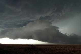
May 31st & June 2nd, 2005 Texas & Colorado Supercells
Despite strong shear and better moisture, both of these days would prove unfruitful for tornadoes. However, two incredible supercells developed that had beautiful structure. The second supercell, June 2, also produced a weak tornadic circulation near Arriba, Colorado. Both of these storms turned HP, and produced hail baseball to softball size.
May 25 – 30th, 2005 New Mexico & Colorado Supercells
The last week in May was to prove unfruitful for tornadic supercell development. Very few tornadoes occurred, and even those that formed were weak. Due to upslope flow into New Mexico and Colorado, I would spend the entire week there. I captured numerous supercells, and a couple of weak tornadoes.
May 20th, 2005 Harding County, South Dakota Supercell
What a remarkable day this turned out to be. We were in O’Neill, NE overnight and decided to blast towards northwest South Dakota for what we hoped would be a nice high based supercell. And what a supercell it was! We spent some leisure time in Belle Fourche, SD waiting for things to happen. We spotted a tower to our north and blasted to the Buffalo area. When we arrived we witnessed a convective explosion!!! A gorgeous rock hard updraft formed and produced one of the most scenic supercells I have seen this year. This storm produced hail golfball sized and was tornado warned for two hours. We were witness to several funnels, but could never confirm any touchdown. Several times, the clear slot produced a nice wall cloud, only to be shrouded by rain and hail.
May 17th, 2005 North Platte, Nebraska Supercell Spin-ups
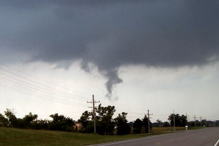
We spent the night in North Platte on the 16th, thus allowing us to stay in the area for the 17th. Everything pointed to strong linear forcing and a quick evolution into a squall line for any storm that formed. By mid afternoon, a triple point became very clear southwest of North Platte. We were able to sit and watch a supercell develop on the triple point. What a treat!!! This storm was fairly high based, but produced several spins ups, a couple tornadic and many on the gust front.
May 13th, 2005 Northwest Texas Supercell
This was a tough day for me. It looked like a potential for a tornado outbreak near the Red River that ended up never materializing. Surface moisture was shallow and mixing lowered dewpoints and allowed storms to be high based and outflow dominant quickly. There was a tornado on the storm we were on, but we never had great visibility of it. This was a MONSTER spiraling high precipitation supercell that was the most electrified storm this year so far. We intercepted it north of Paducah, TX and stayed with it all the way to Throckmorton.
May 12th, 2005 South Plains, Texas Tornadoes & Hailstorm
It was the day in between tours and Dr Dave Gold rallied the troops to meet me in OKC early. We didn’t get out the door till 1 PM, headed southwest towards the triple point near Plainview. By 3 PM we were hearing of tornado reports and the Baron system showed a nice supercell near Plainview. I thought we would get storms firing off that boundary most of the afternoon, but never figured on what we saw.
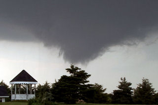
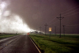
We arrived southeast of Silverton by 5 PM and watched as the eastern supercell spun and tried hard, but developed outflow problems. We finally blew it off and headed through Silverton and south towards South Plains. The storm looked MONSTROUS and very HP. As we approached 207/689 intersection a tapered elephant trunk tornado formed just to our southwest. This tornado widened and strengthened as it moved east across 207. We SLOWLY drove south as it approached the highway, and at one point were about 200 yards north of it, getting the best contrast we could get. We had a Japanese film crew with us who had a probe similar to Tim Samaras’s, and they were able to drop it in the path of this tornado. The footage was INCREDIBLE!
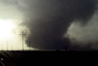
The tornado crossed 207 and dissipated about one mile east of the highway. According to my time stamp on my camcorder, it was on the ground for 12 minutes. Many power poles were down, blocking 207, with some out buildings destroyed. It missed South Plains by about 2 miles or it could have been devastating!!! A second broad circulation developed about two miles east of the first tornado and a multivortex tornado formed. The motion in the cloud base and the tornado was horrendous!!!!! At one time I counted 4 vortices in this tornado. Then the real fun started as we were getting softball sized hailstones wrapping around the back of the tornadic circulation. It dissipated after about 5 minutes. Due to softball sized hailstones, we stopped and to seek shelter in a farmer’s tin carport. Then we had to sit and watch as baseball to softball sized hail took the farmhouse apart, along with trees and two windows in the van as we couldn’t get it totally under the shelter. One of the most prolific hailstorms I have EVER witnessed. Then we took off and headed east to Childress and watched the fantastic CG display with this monster!
May 10th & 11th, 2005 Supercells & Tornado
An interesting period for May 10 and 11. I captured an incredible mothersip supercell May 10 near Grand Island . This storm formed on the triple point and became one of the prettiest supercells, structure wise, that I had ever seen. It almost immediately started rotating and became severe quickly after it formed. There were many reports of tornadoes with this storm, none of which I believe are true. It was fairly high based its entire life.
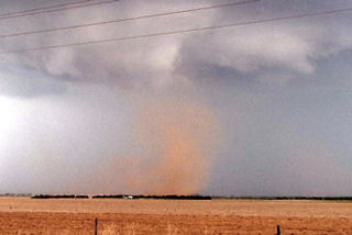
On May 11 we left Kearney mid morning headed south towards Stockton , Kansas . When we arrived it was 81/68 with a nice southeast wind early afternoon. We watched as soft towers would go up and get sheared over. We ended up chasing the cell that was tornado warned northwest of Stockton . These cells were high based, and not very organized. As they crossed front, they became even more elevated and did not much of anything.
Mid afternoon we blew of this junk and headed west to the triple point as cell exploded there. We arrived near Benkelman and came over a hill to catch a glimpse of a weak skinny tornado west of town. The storms looked linear somewhat with a shelf cloud racing northeast. Updrafts were visible behind the shelf. Then something weird happened. My temp and dewpoint went from 63/59 to 71/64 in a matter of 1 minute. All of a sudden an updraft base starting rapid cascading motion, then rapid anticyclonic twisting and turning. Then a loud waterfall sound formed and a few seconds later a tapered cone funnel formed almost overhead. As quick as all the happened, less than a minute, a debris cloud formed in a field just to the southwest of the van. RFD hit the van on the NORTH side of the tornado, which we determined WAS anticyclonic!
We blasted north away of this northeast moving tornado as condensation developed to the ground. Our view out the west side of the van was one of condensation lifting with multiple vortices twisting and turning as debris, old corn stalks and tumbleweeds went flying up and rapidly rotating around the vortex! This tornado was no more than 100 yards from us and closing. We drove at a fast pace to get away from this tornado and managed to get a quarter mile away and we stopped. It immediately dissipated as the funnel rapidly vanished. This entire sequence happened in 3 minutes!