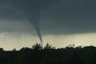
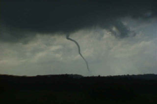
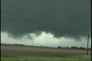
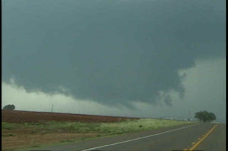
May 6 was an incredible day. It was to be the “day after the big day” type scenario. On May 5, a couple of weak tornadoes occurred, but did not destroy the set up for May 6. The morning models showed an explosive situation with over 5,000 j/kg of CAPE, strong westerly 500 mb winds across southern Oklahoma, and an old boundary. We headed south towards the Ardmore area to play the better shear, and much to our dismay, severe thunderstorms developed back in Oklahoma City where we had come from. The temptation to go back and chase these cells was short lived as two explosive supercells developed in a north/south line from Springer to Overbrook. The first storm produced the first tornado below, an F2 that was gorgeous. The second storm also produced an F2 near the town of Overbrook. Finally we ended up near Denton, Texas chasing a gorgeous LP supercell that is shown in the last photos.
May 3rd, 2001 Morton, Texas HP
After a quick return southward from the Glenville, Minnesota chase, the Texas panhandle was the place of choice. Rapidly returning moisture from the gulf on southeasterly winds pushed the dewpoints to near 70 at Lubbock. An old stationary front and an approaching short wave trough would be the fuel this day to kick off a large HP supercell thunderstorm. This storm produced over a half foot of rain near Morton, Texas as well a copious amounts of baseball sized hail. Further a small fairly weak tornado did occur and I was able to catch it on film.
May 1st, 2001 Glenville, Minnesota Tornadoes
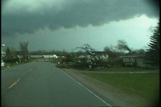
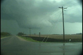
The day of May 1, 2001 will live a long time in my mind. The day started out with a potentially explosive situation in northwest Iowa and southwest Minnesota. A strong low with associated warm front was approaching the area from South Dakota, as well as a pronounced dry punch from Nebraska. Our thoughts were to get in position at the nose of the dry punch. Several tornadic supercells developed in Minnesota before we could make it there. However, little did we know that the tail end storm, the Glenville storm, was to be the most spectacular show of the day, and maybe of the season. The cell developed in Winnebago county, Iowa and intensified as it crossed the border into Minnesota. It rapidly developed one of the most incredible large rotating wall clouds I have ever seen, followed by an awesome tornado. Unfortunately it hit parts of the town of Glenville. A second even larger tornado developed after an occlusion near the town of Austin, Minnesota, followed by a third “Wizard of Oz” type tornado near Rosebud, Minnesota.