
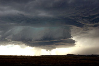
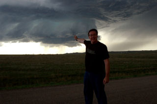
May 20th, 2005 Harding County, South Dakota Supercell
What a remarkable day this turned out to be. We were in O’Neill, NE overnight and decided to blast towards northwest South Dakota for what we hoped would be a nice high based supercell. And what a supercell it was! We spent some leisure time in Belle Fourche, SD waiting for things to happen. We spotted a tower to our north and blasted to the Buffalo area. When we arrived we witnessed a convective explosion!!! A gorgeous rock hard updraft formed and produced one of the most scenic supercells I have seen this year. This storm produced hail golfball sized and was tornado warned for two hours. We were witness to several funnels, but could never confirm any touchdown. Several times, the clear slot produced a nice wall cloud, only to be shrouded by rain and hail.
No comments yet.