
May 16th-17th, 2004 Central Kansas Supercells
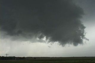
I was to play the boundary in central Kansas these two days. May 16 was a tough forecast with the greatest potential for tornadic supercells in Nebraska. We sat in North Platte till things got a bit clearer. We decided to head south into northern Kansas as heating and instability was best there. However, as we drove south of McCook a supercell exploded 45 miles to our east. Too late to catch this northeast (and soon to be tornadic) moving at 45 mph supercell. We continued our trek south. When we arrived at our target of Oakley, a beautiful rotating supercell was southwest of us. We core punched to get in front of it and encountered hail almost softball sized. It was incredible! We stayed south of this storm as inflow raged at a clocked 72 mph!! If dewpoints would have been mid 60s instead of mid 50s I am certain large tornadoes would have occurred. Near dark an absolutely gorgeous mothership supercell formed as we watched in awe. This storm had a nice funnel cloud but could not touch down and become tornadic.
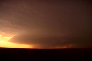
The next day would have us continuing to play the boundary/triple point just west of Hays. By mid afternoon convection fired west of Hays and could not sustain itself. Finally a cluster of storms formed east of Hays from which a nice classic supercell tracked along I70 from Russell eastward. This storm tried very hard to produce a tornado, but couldn’t quite focus rotation strong enough in the updraft to do it. Several times rapidly rotating wall clouds would form only to dissipate as occlusion after occlusion occurred. Finally, near Wilson, the storm dissipated.
No comments yet.